Iceland's Land Parcels, Soils & Vegetation on Your iPhone & iPad
Iceland's land data comes from a handful of public bodies. The Housing and Construction Authority, HMS, keeps the land register, Landeignaskrá, and the address register, Staðfangaskrá. The Icelandic Institute of Natural History (Náttúrufræðistofnun) publishes the vegetation and geology maps, the Agricultural University of Iceland (Landbúnaðarháskóli Íslands) the soil map, Land og skógur the soil erosion survey, and the Nature Conservation Agency (Náttúruverndarstofnun) the areas where hunting is banned.
GoGIS has an Iceland section in Reference Data with eight of their datasets. Move the map to your area, pick one, and it downloads as a layer on your iPhone or iPad that you can read, search, combine with your own data and take into the field without a signal. Columns are in English; the values stay Icelandic, with the English after them where there is one: Graslendi – Grassland.
What you can do with it in GoGIS
Download the data oncePick the layers you need from Reference Data. They stay on your phone and work with no signal.

Tap the map, even with no signalRead everything the publisher records about the parcel, field or area under your finger.

Photos, sketches and notesTake a picture where you stand, sketch on the map, and write down what you saw.

Your photos on the mapSee every photo where you took it, and share a PDF report of the place and your notes.
The Eight Icelandic Datasets
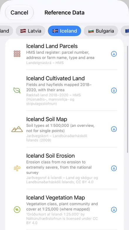
- Iceland Land Parcels — the land register: each parcel's land number, its address or farm name, its type (Lóð – Plot or Jörð – Farm), its part (1/1, 2/3), its registered area and measured part area in square metres, the source of its outline and its status in the register. GoGIS looks up the address register for the same area, so every town plot gets its street address and every rural parcel its farm's name: around Selfoss, 2,940 of 2,980 parcels got one. The layer arrives labeled by land number. Landeignaskrá – HMS (Húsnæðis-, mannvirkja- og skipulagsstofnun); addresses from Staðfangaskrá – HMS. Boundaries are indicative: the registered deeds govern.
- Iceland Cultivated Land — fields and hayfields mapped from 2018 to 2020, with each one's area in hectares, measured from its outline. Ræktað land 2018–2020 – HMS (Húsnæðis-, mannvirkja- og skipulagsstofnun)
- Iceland Soil Map — soil types at 1:500,000, in Icelandic with the international names: Brúnjörð – Brown Andosols, Melajörð - Malarjörð – Cambic Vitrisols, Gravelly Vitrisols. An overview, not for single points. Colored as LbhÍ colors it. Jarðvegskort – Landbúnaðarháskóli Íslands (2009)
- Iceland Soil Erosion — the national erosion survey's class for each area, from Ekkert rof – No erosion (0) to Mjög mikið rof – Extremely severe erosion (5), with mountains, glaciers and water, and the survey's code. Jarðvegsrof á Íslandi – Land og skógur og Landbúnaðarháskóli Íslands, CC BY 4.0
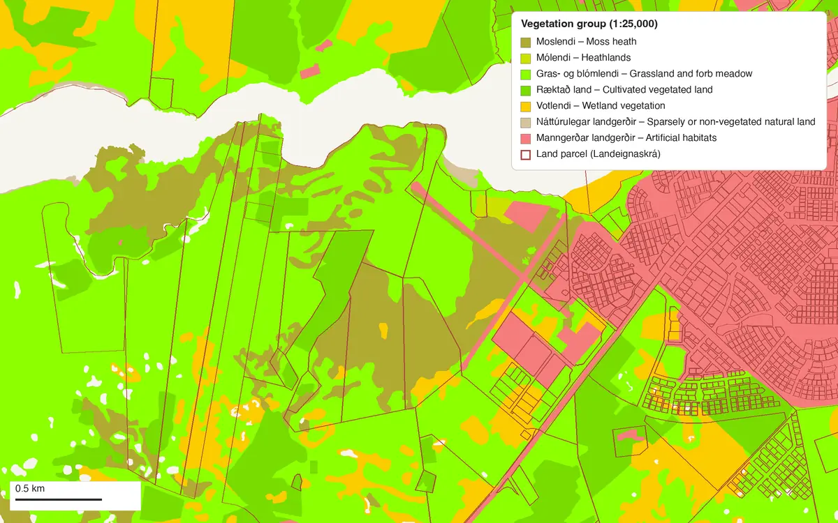
- Iceland Vegetation Map — the 1:25,000 vegetation map where it has been made: each area's vegetation class (Mýri – Sloping fens, Lyngmói – Ericaceous shrub heath), its group, its plant community code as the Institute's key writes it, and its vegetation cover, from under 10% to over 90%. The English is the Institute's own, from its vegetation key. 'Gróðurkort af Íslandi 1:25.000' by Náttúrufræðistofnun is licensed under CC BY 4.0
- Iceland Bedrock Geology — rock type and age at 1:600,000, from Söguleg basísk og ísúr hraun, yngri en 871 e.kr. – Historic basic and intermediate lavas, younger than 871 AD to Blágrýti, eldra en 3,3 milljón ára – Extrusive rocks with intercalated sediments, older than 3.3 m.y., colored as the Institute's own map. 'Jarðfræðikort af Íslandi 1:600.000' by Náttúrufræðistofnun is licensed under CC BY 4.0. Haukur Jóhannesson, Kristján Sæmundsson, Jarðfræðikort 1:500.000.
- Iceland Ptarmigan Hunting Bans — the 51 protected areas where ptarmigan hunting is not allowed, with name, designation (Friðland – Nature Reserve), year designated and a link. Bannsvæði rjúpnaveiða – Náttúruverndarstofnun
- Iceland Fox Hunting Bans — the 39 protected areas where fox hunting is not allowed, by name. Bannsvæði refaveiða – Náttúruverndarstofnun
Parcels, Addresses and Farm Names
In the Icelandic countryside the address is the farm's name, so the Address / Farm column turns a land number into a place you can ask for: Laugardælur, Stekkar. In town it's the street and house numbers, several where a plot has several: Gráhella 53, 55, 57. An address point outside the map area isn't looked up, so a parcel that runs past the edge of the screen may come without one.
The register's own notes travel with each parcel. Source says where the outline came from: Þinglýst skjöl/Skjöl frá sveitarfélagi – Registered deeds / municipal documents, Merkjalýsing – Boundary description, or Óviss fitja – Uncertain outline, which around Selfoss is about half of them. HMS's outlines are indicative; the registered deeds govern.
How to Download the Layers
- Move the map to your area. Search for a town or a farm, or pan and zoom to the land you want. GoGIS downloads what's on the screen.
- Open Reference Data. Tap Import, then Reference Data. The row of countries along the top opens on the one the map is showing, so with the map in Iceland, the Iceland datasets are the ones listed. The app isn't in Icelandic, so the buttons are in English or your phone's language.
- Choose a dataset. Most areas come in a few seconds: around Selfoss, the parcels with their addresses took four, the vegetation map one.
- Read the map. Tap anything to see everything about it. The soil, erosion, vegetation and bedrock layers arrive colored with a legend.
Next step: open a layer's attribute table to search the parcels for a farm name in Address / Farm, filter the vegetation map by vegetation class or the erosion survey by its class, and export the list to Excel as a CSV. See the attribute table on iPhone and iPad.
Good to Know
- The hunting-ban areas come exactly as published. The Nature Conservation Agency's terms say their boundaries must not be changed, so GoGIS imports them without simplifying or clipping them.
- The vegetation map isn't national. It covers the highlands and much of the mapped lowland, and only the Institute's own areas: water outlines drawn by a private company in some areas are left out.
- The soil map is an overview. At 1:500,000 it shows what soils dominate a district, not what's under your boot.
- The bedrock map leaves out ice and lakes. A few glacier and lake outlines carry no rock type, so they're left blank, as on the Institute's own map.
Protected areas too. In the Europe section, Nationally Designated Areas (NatDA) holds Iceland's 134 nationally protected areas, from national parks to nature reserves. Natura 2000 doesn't cover Iceland. Across the water, Reference Data also has Norway's property map; see Reference Data by country for the rest.
Questions
Do the parcels show who owns them?
No. The land register layer has no owners' names. It does carry the address, which in the countryside is the farm's name.
Are the parcel boundaries exact?
No. HMS says its boundaries are indicative and that the registered deeds govern, and the Source column tells you how each outline was made. For a boundary on the ground, a surveyor has the last word.
Can I hunt where there's no ban area?
The layers show the protected areas where ptarmigan or fox hunting is banned. Other rules still apply, such as seasons, permits and the landowner's permission, so check them before you go.
Is the app in Icelandic?
No. The dataset names are in the app's language and the columns in English, while the values stay Icelandic with their English beside them.
Do I need desktop GIS software, an account or an API key?
No. GoGIS downloads from each publisher's open service. There's no key, no account and nothing to unzip.
Iceland's land, in your pocket
Parcels, soils, vegetation and hunting-ban areas, ready to download on your iPhone or iPad.
Get GoGIS on the App Store Get GoGIS on Google Play