Europe's National Parks & Protected Areas on Your iPhone & iPad
Every European country protects land under its own laws: national parks, nature reserves, landscape protection areas, natural monuments, forest reserves. The European Environment Agency gathers them into one Europe-wide dataset, the Nationally Designated Areas (NatDA, formerly CDDA), published under CC BY 4.0. It sits beside Natura 2000, the EU's network under its Habitats and Birds directives: many sites are both, but a national park or a cantonal reserve is often only in NatDA, and outside the EU there is no Natura 2000 at all.
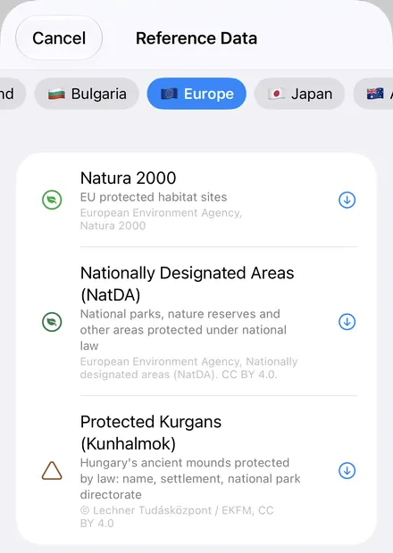
GoGIS has both in the Europe section of Reference Data. Nationally Designated Areas (NatDA) covers 37 countries: the 27 EU member states and Albania, Bosnia and Herzegovina, Iceland, Kosovo, Liechtenstein, Montenegro, North Macedonia, Norway, Serbia and Switzerland. Move the map to your area, pick it, and the protected areas download as a layer on your iPhone or iPad that you can take into the field without a signal.
What you can do with it in GoGIS
Download the data oncePick the layers you need from Reference Data. They stay on your phone and work with no signal.

Tap the map, even with no signalRead everything the publisher records about the parcel, field or area under your finger.

Photos, sketches and notesTake a picture where you stand, sketch on the map, and write down what you saw.

Your photos on the mapSee every photo where you took it, and share a PDF report of the place and your notes.
What's in the Layer
Each protected area comes with five columns, named in the app's language: Name, Designation, IUCN Category, Year Designated and Area (ha). The values are in English, apart from the names, which stay as each country writes them.
- Designation is the national designation, named from the EEA's code list of 757 designation types: National Park, Nature Park, Landscape Protection Area, Forest Reserves. The layer itself carries only a code, so GoGIS gives it its name; a handful of codes the list lacks show as the code.
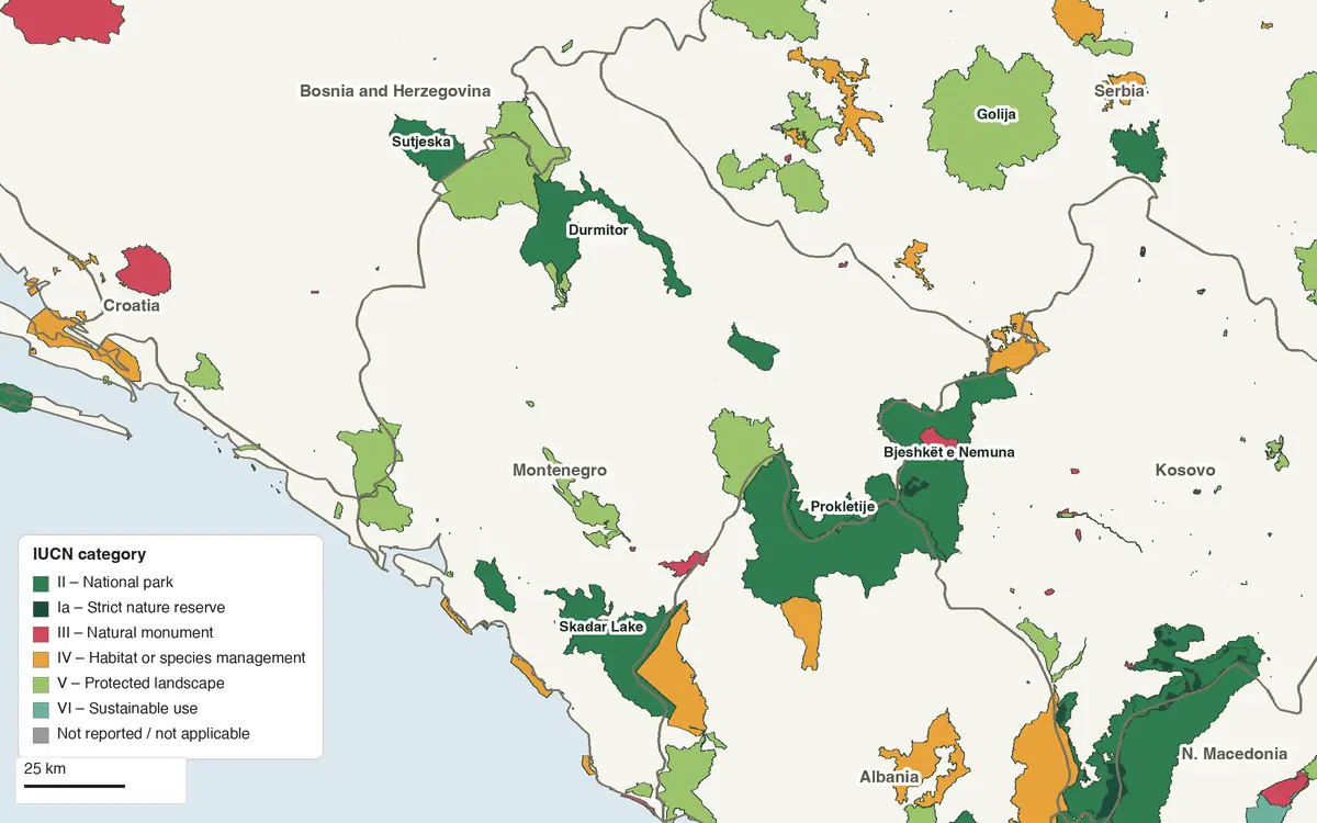
- IUCN Category is written out: II – National park, IV – Habitat or species management, V – Protected landscape, or Not reported where the country gave none.
- Year Designated and Area (ha) are as each country reported them, and empty where it didn't.
Around Montenegro, the largest national parks are Alpet e Shqiperise in Albania (82,845 ha, designated 2022), Bjeshkët e Nemuna in Kosovo (62,488 ha, 2012), and Skadarsko jezero (40,000 ha, 1983) and Durmitor (32,519 ha, 1952) in Montenegro; the largest nature park is Serbia's Golija (75,838 ha, 2024). The layer arrives in one deep green, labeled by name; color it by IUCN Category or Designation for a map like the one above.
European Environment Agency, Nationally designated areas (NatDA). CC BY 4.0.
NatDA and Natura 2000
Natura 2000 covers the 27 EU member states only. With the map in one of the ten other countries, GoGIS greys it out and keeps NatDA. Serbia, Kosovo, Montenegro, North Macedonia, Albania and Bosnia and Herzegovina now open the Europe section too, with NatDA in it. Natura 2000 is drawn in a lighter green, NatDA in a deeper one, so you can download both and tell them apart.
Sites per country, as the EEA's service counted them on 11 November 2026, 138,867 in all:
| Country | NatDA sites | Natura 2000 in GoGIS |
|---|---|---|
| Albania | 53 | No (not in the EU) |
| Austria | 1,257 | Yes |
| Belgium | 2,520 | Yes |
| Bosnia and Herzegovina | 51 | No (not in the EU) |
| Bulgaria | 1,097 | Yes |
| Croatia | 329 | Yes |
| Cyprus | 141 | Yes |
| Czechia | 2,770 | Yes |
| Denmark | 572 | Yes |
| Estonia | 20,557 | Yes |
| Finland | 18,005 | Yes |
| France | 8,134 | Yes |
| Germany | 18,326 | Yes |
| Greece | 803 | Yes |
| Hungary | 328 | Yes |
| Iceland | 134 | No (not in the EU) |
| Ireland | 161 | Yes |
| Italy | 1,048 | Yes |
| Kosovo | 67 | No (not in the EU) |
| Latvia | 6,380 | Yes |
| Liechtenstein | 44 | No (not in the EU) |
| Lithuania | 489 | Yes |
| Luxembourg | 224 | Yes |
| Malta | 279 | Yes |
| Montenegro | 60 | No (not in the EU) |
| Netherlands | 198 | Yes |
| North Macedonia | 60 | No (not in the EU) |
| Norway | 3,469 | No (not in the EU) |
| Poland | 2,229 | Yes |
| Portugal | 219 | Yes |
| Romania | 946 | Yes |
| Serbia | 397 | No (not in the EU) |
| Slovakia | 1,197 | Yes |
| Slovenia | 1,057 | Yes |
| Spain | 1,797 | Yes |
| Sweden | 32,834 | Yes |
| Switzerland | 10,635 | No (not in the EU) |
The counts vary as much with how a country designates as with how much it protects: Sweden and Estonia list tens of thousands of small reserves and protected features, Montenegro its parks one by one.
How to Download the Layer
- Move the map to your area. Search for a place, or pan and zoom to the land you want. GoGIS downloads the protected areas that touch the screen, whole.
- Open Reference Data. Tap Import, then Reference Data, and open the Europe section.
- Choose Nationally Designated Areas (NatDA). It's listed right after Natura 2000. A valley or a district comes in a second or two.
- Read the map. Tap an area for its name, designation, IUCN category, year and area.
Next step: open the layer's attribute table to filter the areas by Designation or IUCN Category, sort them by Year Designated, total their Area (ha) with a column summary, and export the list to Excel as a CSV. See the attribute table on iPhone and iPad.
Put the Layer to Work
- Know when you're inside a protected area. With your GPS position on the map, see whether you're in a national park, a nature reserve or a protected landscape, offline.
- Plan work near a site. Draw a buffer around your fields, a route or a building plot and intersect it with the protected areas.
- Combine national and EU protection. Download Natura 2000 too, and see where the two overlap and where only national law applies.
- Export or print. Share the layer as a Shapefile, GeoPackage, KML, GeoJSON or CSV, or print a PDF map, with the EEA's credit on it.
Your country's own land data. Many countries also have parcels, crops or soils in Reference Data: Switzerland, Iceland, Latvia, Norway and more. See Reference Data by country.
Questions
What's the difference between NatDA and Natura 2000?
Natura 2000 is the EU's own network of sites under the Habitats and Birds directives, in the 27 member states. NatDA lists the areas each country protects under its national law, in 37 countries. Many places are in both; a national park or a nature reserve is in NatDA even where it isn't a Natura 2000 site.
Are the designations in my language?
The column names are, in every app language. The designations come from the EEA's code list, which is English only, and the site names are as each country writes them.
Why do some designations look vague?
They're the EEA's own names for each country's codes, and a few are generic: Romania's 492 areas under its Law 5/2000 are “Not Assigned”, for example. GoGIS shows the name as published.
Does it include Turkey or the United Kingdom?
No. The EEA's current NatDA has no sites for either.
How current is it?
GoGIS reads the EEA's NatDA version 24, as its service publishes it, each time you download.
Do I need desktop GIS software, an account or an API key?
No. GoGIS downloads from the EEA's open service. There's no key, no account and nothing to unzip.
Europe's protected areas, in your pocket
National parks and nature reserves in 37 countries, ready to download on your iPhone or iPad.
Get GoGIS on the App Store Get GoGIS on Google Play