WISCONSIN COUNTY PARCEL MAPS
Taylor County parcel map and property owners
WI 2026 puts all 25,650 parcels in Taylor County on your phone: owner names, site addresses, assessed values and acreage from the county’s 2025 tax roll. The county download is about 5 MB, and once it’s on your phone you can search it and tap any parcel with no signal.
The parcels cover 629,474 mapped acres across 27 towns, villages and cities, and 8 school districts. The most parcels are in the City of Medford. The data is the State Cartographer’s Office V12 statewide parcel map, loaded from the county on February 12, 2026.
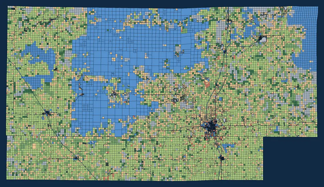
- Agricultural
- Productive forest
- Undeveloped / ag forest
- Residential
- Commercial / manufacturing
- Government-owned / county forest
- Other / unclassified
What the Taylor County records include
Counties fill in the statewide schema differently. This is how complete Taylor County’s 2025 records are:
| Field | Filled in |
|---|---|
| Owner name | 99.9% of parcels |
| Site (street) address | 41.5% of parcels |
| Assessed or estimated value | 81.6% of parcels |
| Assessed or deeded acres | 99.7% of parcels |
| Net property tax | 81.6% of parcels |
Only 41.5% of parcels have a street address, which is normal for rural land: fields and woods often have no house number. Search by owner name or parcel ID to find those.
How the land is classed
By mapped area, Taylor County is agricultural 32%, government-owned / county forest 25%, residential 18%, undeveloped / ag forest 10%. The median estimated fair market value of a residential parcel is $140,300, across 6,070 residential parcels with a value.
In WI 2026, open the legend and color the map by Class of Property to see the same picture, or by Estimated Fair Market Value to see where values rise and fall.
Deer season: public land and Managed Forest Law
The tax roll marks parcels that are government-owned or enrolled in Wisconsin’s forest tax programs. In Taylor County:
- Federal-owned: 123,883 acres in 1,053 parcels
- State-owned: 9,976 acres in 318 parcels
- County-owned: 2,921 acres in 377 parcels
- County forest crop land: 17,982 acres in 453 parcels
- Managed Forest Law, open to public hunting, fishing, hiking, sightseeing and cross-country skiing: 13,985 acres in 375 parcels
- Managed Forest Law, closed (no public access without permission): 61,289 acres
In WI 2026, color the map by Auxiliary Class of Property to see these parcels, and tap one for the owner and acreage. The acreages are whole-parcel areas from the tax roll: a parcel that is only partly enrolled counts in full, and the tax roll doesn’t show posted areas or access routes. Before you hunt, check the DNR’s map of private forest land open to the public and the signs on the ground.
Towns, villages and cities in Taylor County
Every parcel carries its municipality, so you can search a town name in WI 2026 or filter the attribute table to one place. Parcel counts in the 2025 data:
- City of Medford 2,345
- Town of Medford 1,901
- Town of Westboro 1,856
- Town of Rib Lake 1,750
- Town of Greenwood 1,180
- Town of Little Black 1,178
- Town of Chelsea 1,131
- Town of Hammel 1,029
- Town of Browning 967
- Town of McKinley 908
- Town of Holway 865
- Town of Deer Creek 853
- Town of Goodrich 847
- Town of Maplehurst 816
- Town of Roosevelt 813
- Town of Grover 779
- Town of Aurora 774
- Town of Pershing 729
- Town of Taft 722
- Town of Molitor 699
- Town of Jump River 691
- Town of Cleveland 667
- Town of Ford 623
- Village of Rib Lake 489
- Village of Stetsonville 448
- Village of Gilman 381
- Village of Lublin 193
Working near the county line?
Taylor County borders Chippewa County, Clark County, Lincoln County, Marathon County, Price County and Rusk County. Download the neighboring counties too, and WI 2026 searches across all of them at once.
Where the data comes from
Parcel data is the Wisconsin Statewide Parcel Map Database (V12), a public-domain product of the Wisconsin Land Information Program and the State Cartographer’s Office, UW–Madison, built from Taylor County’s 2025 tax roll. It is a snapshot, not a live feed: for a sale, a survey or a tax question, check with Taylor County directly.