WISCONSIN PARCEL GUIDES
How to download Wisconsin parcel maps for offline use
Download the counties you need in WI 2026 while you have internet access. The downloaded parcel data stays on your device. Background maps and aerial imagery may still need a connection.
A day visiting properties or checking fields can take you beyond reliable cell service. A little preparation lets you bring the parcel records with you.
1. Choose your counties before heading out
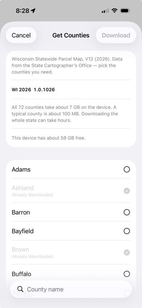
Open WI 2026 and select Get More to open Get Counties. Choose the county for your trip. If you’ll be crossing a county line, download both counties.
You can keep one county, several counties, or all 72 Wisconsin counties on your device. Downloading the whole state also lets you search across all those county records.
2. Check the available space
The download screen shows your device’s free space. A typical county takes about 100 MB; all 72 counties take about 7 GB in WI 2026. These are estimates, and county sizes vary. Leave additional room for photos, other apps, and normal device use.
3. Download and let the import finish
Select your counties, then tap Download. Use a reliable connection; Wi-Fi is a practical choice for several counties or the whole state. Keep the app open until the download and import finish.
Large counties can take several minutes, and a whole-state download can take hours. Start before your trip, rather than just as you’re leaving. Counties already on your device are marked Already downloaded in the county list.
4. Check your setup without a connection
Before leaving, open a downloaded county and find a familiar parcel. Then temporarily turn on airplane mode and make sure Wi-Fi is off. Check that you can open the parcel record and search the downloaded data you expect to use. Restore your normal connection afterward.
This is also a useful way to see which background map details remain available on your device. Don’t assume that seeing aerial imagery while connected means it has been downloaded for your entire trip.
What is available offline?
| What you need | What to expect |
|---|---|
| Downloaded county parcels | Parcel data stays on your device until you remove it. |
| Owner, address, and parcel searches | Search the county data you’ve already downloaded. Statewide searches need all counties downloaded. |
| Background maps and aerial imagery | May require internet access. A county parcel download does not guarantee offline imagery. |
| More counties | You need a connection to download additional county data. |
| Sending a report to someone | Email or messaging needs a connection to deliver the report. |
Does downloading make the records current?
It gives you the dataset offered by WI 2026, not a live feed of ownership changes. The app uses Wisconsin’s V12 (2026) statewide parcel data. Check the State Cartographer’s data notes and consult the county when you need current ownership or tax information.
Ready to look up a property?
With your county downloaded, follow our guide to finding a Wisconsin property owner by address. You can keep photos, sketches, and notes with a parcel, so your observations stay connected to the place.