Córdoba's Soil Map on Your iPhone & iPad
The province of Córdoba publishes its soil map through IDECOR, its spatial data infrastructure (Infraestructura de Datos Espaciales de Córdoba). Across the farming east of the province it is the Carta de Suelos 1:50.000, a semi-detailed map of every soil series; elsewhere, coarser maps at 1:100,000 and 1:500,000 fill in. Every area is rated by its land capability class and a productivity index, the numbers that matter when you plan a field or value it.
GoGIS now has an Argentina section in Reference Data. Move the map to your area in Córdoba, choose Córdoba Soils, and it downloads as a layer on your iPhone or iPad, colored by land capability with the legend ready. The map covers the province of Córdoba only: near the border it stops at the provincial line, with nothing on the Santa Fe, Buenos Aires or San Luis side.
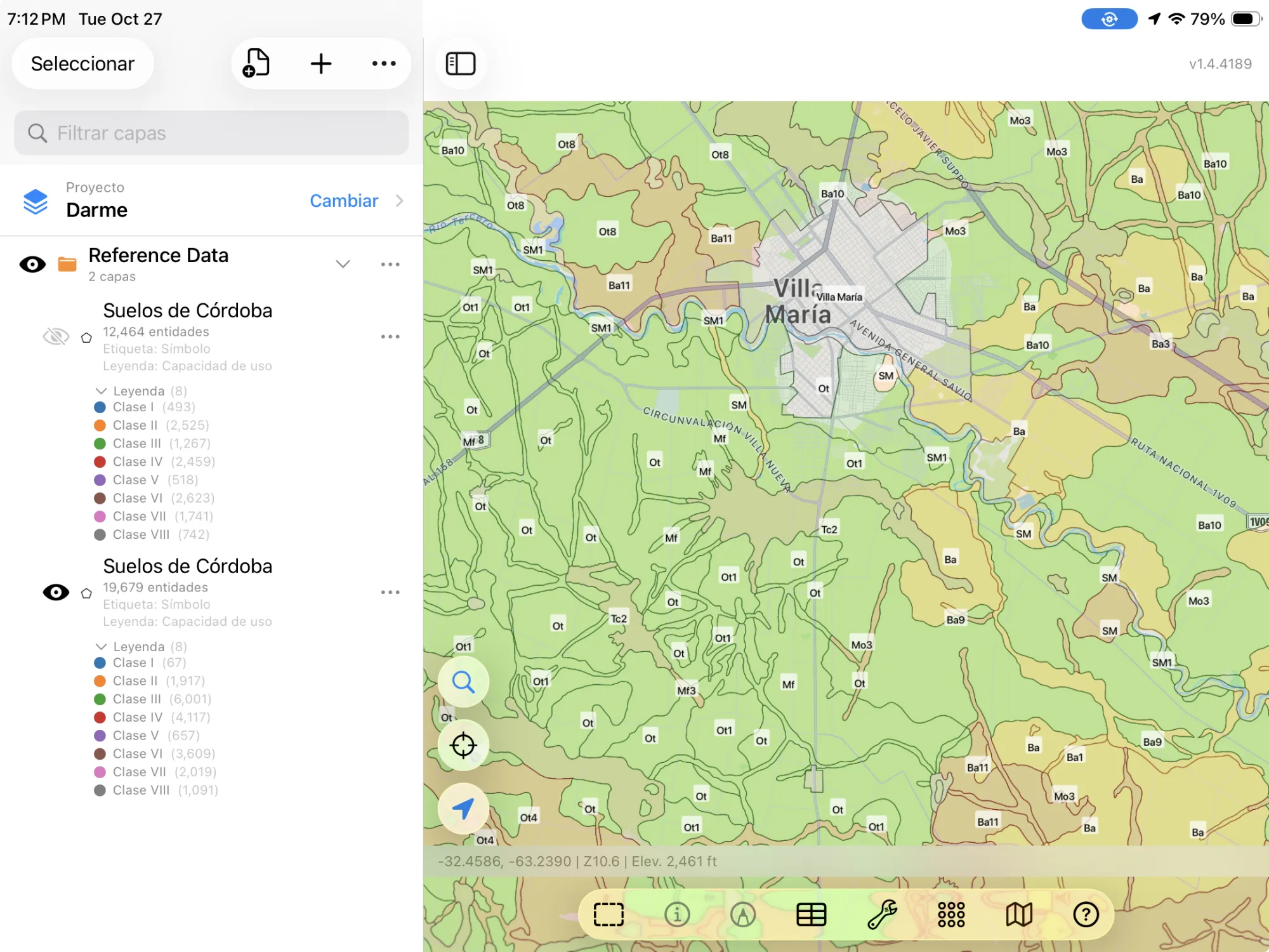
The Dataset
- Córdoba Soils — IDECOR's soil map, the most detailed one for each place. From the 1:50,000 Carta de Suelos (2025): each map unit (named for its main soil series, such as Monte Buey, or a complex of them), its symbol, the kind of unit (consociation, association, complex), its land capability class and subclass, its productivity index (0–100), and its main soil series with its share. Where the 1:50,000 map doesn't reach yet: the unit's symbol, capability class and subclass, and productivity index from the 1:100,000 or 1:500,000 map. A Scale column says which map each area comes from. The layer arrives colored by land capability class, best first. Fuente: IDECOR – Provincia de Córdoba, Carta de Suelos 1:50.000 (2025). CC BY-SA 4.0.
The Land Capability Classes
The soil map rates each unit by the land capability classification, from Class I, land with few limits for crops, to Class VIII, land not fit to farm. The subclass says what limits it: c for climate, e for erosion, s for the soil itself, w for excess water. The productivity index runs from 0 to 100, the best soils in the province at the top.
| Class | In short |
|---|---|
| I – II | Crops with few limits; II needs some care |
| III – IV | Crops with real limits and conservation practices |
| V – VII | Grazing or forest rather than crops |
| VIII | Not for farming: lagoons, dunes, rock |
In English or in Spanish
This is Argentine data, so GoGIS speaks Spanish when you do. With the app set to Spanish, the columns are Unidad, Símbolo, Tipo de unidad, Capacidad de uso, Subclase, Índice de productividad, Serie principal, Escala, and the values read Clase IV, Consociación. In any other language you get English throughout: Map Unit, Land Capability, Productivity Index, Scale, Class IV, Consociation. The soil series' own names stay as the survey writes them.
How to Download the Layer
- Move the map to your area. Search for a town or an address in Córdoba, or pan and zoom to the fields you want. GoGIS downloads what's on the screen.
- Open Reference Data. Tap Import, then Reference Data. The row of countries along the top opens on the one the map is showing, so with the map in Argentina, the Argentina dataset is listed.
- Choose Córdoba Soils. The download keeps going if you switch apps or the screen would otherwise lock, and progress shows on the map. Only the soil areas on your screen come in, not every place in the province a soil unit occurs.
- Read the map. The soils arrive colored by capability class and labeled by symbol. Tap an area to see everything about it.
Put the Layer to Work
- Read a field's soils. Lay the soil map under your fields and see the capability class and productivity index of each part before you plan inputs or set out a sampling grid.
- Combine it with your own data. Use Intersect to cut your field boundaries by the soil map and see how much of each field is Class II or Class IV.
- Export or print. Share the layer as a Shapefile, GeoPackage, KML, GeoJSON or CSV, or print a PDF map. The source credit goes on the print and with the export.
Elsewhere? Reference Data also has OpenStreetMap roads, rivers, buildings and land use for all of Argentina and the rest of the world.
Questions
Why are there no parcels for Córdoba?
IDECOR's public parcel layer holds only a small part of the cadastre, fewer parcels than there are city blocks, so GoGIS doesn't offer it as a cadastre. Argentina has no national parcel service open to reuse, and Buenos Aires province's is switched off.
Why do some areas have less detail?
The 1:50,000 map covers the farming east of the province. Elsewhere, around Villa Dolores and in the hills, the soils come from the 1:100,000 or 1:500,000 map, which name a unit by its symbol only. The Scale column says which map each area comes from.
What does CC BY-SA mean for my maps?
IDECOR's licence lets you use, change and share the data, also commercially, as long as you credit IDECOR and share what you make from it under the same licence. GoGIS keeps the credit on the layer, so it goes on your prints and exports.
Do I need desktop GIS software or an account?
No. GoGIS downloads straight from IDECOR's open service. There's no key, no account and nothing to unzip.
Córdoba's soils, in your pocket
The province's soil map with land capability and productivity, in English or Spanish, ready to download on your iPhone or iPad.
Get GoGIS on the App Store