New Zealand Parcels, Property Titles & Land Use on Your iPhone & iPad
Land Information New Zealand (LINZ) keeps one cadastre for the whole country, updated every day: every parcel with its legal description, its appellation (Lot 2 DP 454160, Rural Section 25679), and every title it sits in. The Ministry for the Environment maps how all of New Zealand's land is used, from planted forest to annual cropland, for the country's greenhouse gas reporting (LUCAS).
GoGIS now has a New Zealand section in Reference Data. Move the map to your area, pick a dataset, and it downloads as a layer on your iPhone or iPad, with areas in hectares and the land use classes in plain words.
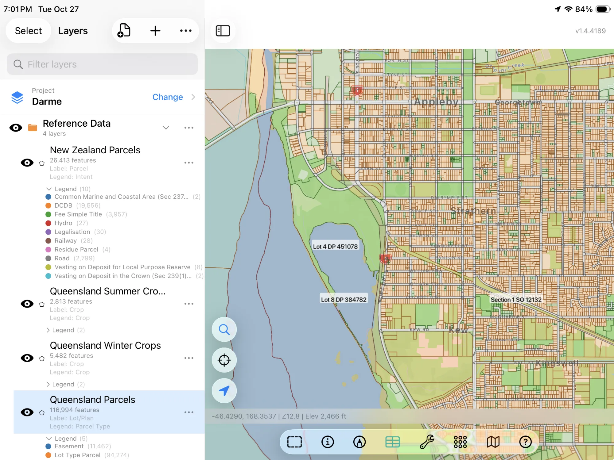
The Three New Zealand Datasets
- New Zealand Parcels — LINZ's primary parcels: each parcel's appellation, what it is for (its intent: Fee Simple Title, Road, Hydro, Maori and more), the titles it is in, its land district, its area as surveyed and as calculated from its outline in hectares, and any statutory actions on it. The layer arrives colored by intent. NZ Primary Parcels, sourced from the LINZ Data Service and licensed for reuse under the CC BY 4.0 licence.
- New Zealand Property Titles — LINZ's live titles: the title number (CB15B/549), its type (Freehold, Leasehold, Unit Title), the estate (Fee Simple, 1/1, Lot 1 Deposited Plan 35961, 364,120 m2), the number of owners, its status, land district, the day it was issued and its guarantee status. The layer arrives colored by type. NZ Property Titles, sourced from the LINZ Data Service and licensed for reuse under the CC BY 4.0 licence.
- New Zealand Land Use (2020) — the LUCAS Land Use Map: each area's land use in 2020 (Natural Forest, Planted Forest - Pre 1990, Grassland - High producing, Cropland - Annual, Cropland - Orchards and vineyards (perennial)), its subclass, its land use in 2016, its region and its area. The layer arrives colored by land use. Ministry for the Environment, LUCAS NZ Land Use Map 2020 (Manaaki Whenua – Landcare Research). CC BY 4.0.
How to Download the Layers
- Move the map to your area. Search for a town or an address, or pan and zoom to the land you want. GoGIS downloads what's on the screen.
- Open Reference Data. Tap Import, then Reference Data. The row of countries along the top opens on the one the map is showing, so with the map in New Zealand, the New Zealand datasets are the ones listed.
- Choose a dataset. The download keeps going if you switch apps or the screen would otherwise lock, and progress shows on the map. LINZ's and the Ministry's servers count what's in the area first; if there are a great many features, GoGIS tells you how many and asks before it downloads them.
- Read the map. Parcels arrive labeled by appellation, titles by title number, land use colored by class. Tap anything to see everything about it.
Put the Layers to Work
- Find a property's title. Tap a parcel for its appellation and titles, or the title layer for the estate and the number of owners.
- See how the district is farmed. The land use map shows the high-producing grassland, the cropland and the forest blocks around you, and what changed since 2016.
- Combine them with your own data. Use Intersect to cut the parcels by land use and see how each property is used.
- Export or print. Share any layer as a Shapefile, GeoPackage, KML, GeoJSON or CSV, or print a PDF map. The source credit goes on the print and with the export.
Across the Tasman? Reference Data also has each Australian state's parcels, Queensland's crops, land use and soils, and OpenStreetMap roads, rivers, buildings and land use anywhere.
Questions
Do the property titles show the owners?
No. LINZ publishes the open title layer without owners' names; it gives the number of owners only.
How current are the parcels and titles?
LINZ updates both every day, and GoGIS downloads them as they are on the day you download.
What's the difference between survey area and area?
The survey area is the area recorded on the survey plan; the area is calculated from the parcel's outline. They are usually close, and not every parcel has a survey area.
Do I need desktop GIS software, a LINZ account or an API key?
No. GoGIS downloads from LINZ's and the Ministry for the Environment's open services. There's no key, no account and nothing to unzip.
New Zealand's parcels and land use, in your pocket
LINZ's parcels and property titles and the LUCAS land use map, ready to download on your iPhone or iPad.
Get GoGIS on the App Store