BLM Mining Claims (MLRS) on a Map, Offline
Every unpatented mining claim on federal land is recorded with the Bureau of Land Management in its Mineral & Land Records System (MLRS), which took over mining claims from the old LR2000 system in 2021. Each claim has a serial number in the new form, a two-letter state code and nine digits (NV101493694), and keeps its legacy serial from before MLRS. Nevada alone has had more than 270,000 active claims, close to half the BLM's total.
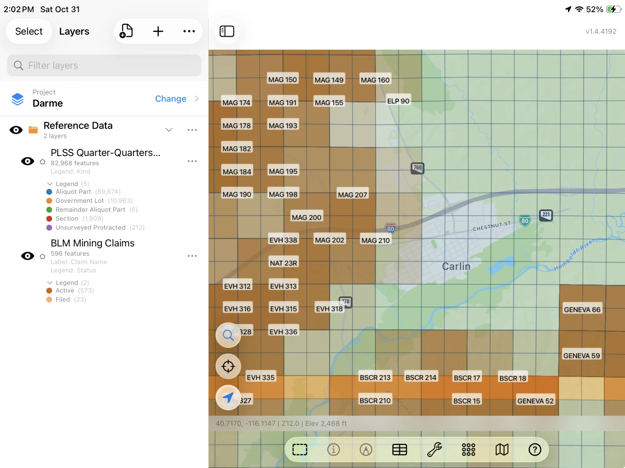
MLRS is built for the people who file claims. GoGIS puts the same claims on a map you can carry: move the map to your area, choose BLM Mining Claims in Reference Data, and every claim that isn't closed arrives as a layer, colored by status, Active in dark orange and Filed in light orange, labeled by name, and readable with no signal.
What you can do with it in GoGIS
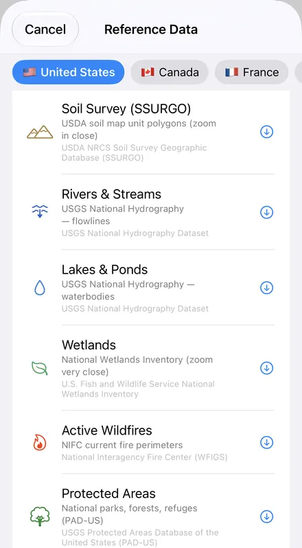
Download the data oncePick the layers you need from Reference Data. They stay on your phone and work with no signal.

Tap the map, even with no signalRead everything the publisher records about the parcel, field or area under your finger.

Photos, sketches and notesTake a picture where you stand, sketch on the map, and write down what you saw.

Your photos on the mapSee every photo where you took it, and share a PDF report of the place and your notes.
What Each Claim Shows
| Column | What it is |
|---|---|
| Claim Name | The name the claimant gave it |
| Serial Number | The MLRS serial, to look the case up |
| Legacy Serial | The number from before MLRS, still on older papers |
| Type | Lode claim, placer claim, mill site or tunnel site |
| Status | Active or Filed |
| Acres | The recorded acres |
| Location (MTRS) | Meridian, township, range and section |
| Updated | When the BLM last changed the record |
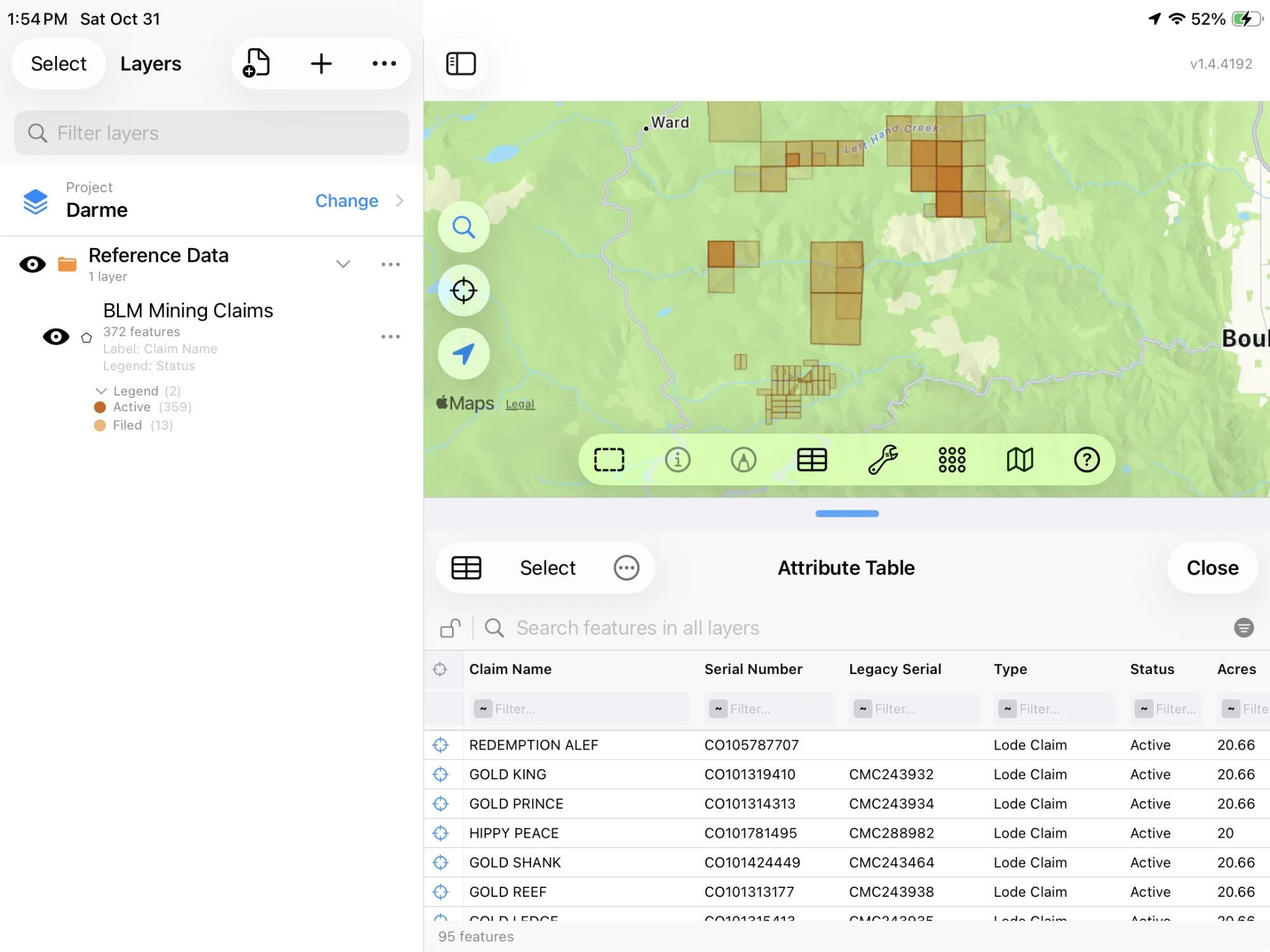
In that table you can filter the claims by Type or Status, sort them by Updated to see what changed lately, total their Acres with a column summary, and export the list to Excel as a CSV. See the attribute table on iPhone and iPad.
How Claims Are Drawn, and Claim Sizes
A claim is staked on the ground, but the BLM maps it by its legal description, as the quarter sections it lies in. Read the layer as which quarter sections have claims in them, then tap a claim for its serial number and look it up in MLRS for the case.
On the ground, a lode claim can be up to 1,500 by 600 feet. A placer claim can be up to 20 acres per locator, and an association placer up to 160 acres for eight or more locators.
Rockhounds, Prospectors and Claim Holders
- Rockhounding and panning: on open BLM land you can collect reasonable amounts for your own use and pan without a permit unless an area is closed, but not on an active claim without the claimant's permission.
- Before you stake: see which quarter sections already hold claims, Active or Filed, with their serial numbers to check in MLRS.
- Holding claims: $200 per claim a year, due by September 1, or the small miner waiver for 10 or fewer. Keep your own claims' corners and notes as a layer of your own in GoGIS next to the BLM's.
More of the BLM's data: the PLSS grid and grazing allotments, a section, township and range finder, and public land pages for Montana, Wyoming, Utah, Idaho, New Mexico, Arizona, Nevada, Colorado, Oregon, California and Washington.
Questions
Where does GoGIS get the claims?
From the BLM's MLRS mining claims layer, which lists every lode and placer claim that isn't closed and is refreshed daily. GoGIS asks for the name, serial numbers, type, status, acres and location; the BLM publishes no claimants' names.
Why are the claims squares that overlap?
MLRS records a claim by its legal description, the quarter sections it lies in, and the BLM maps it as those quarter sections. So a 20-acre claim shows as a 160-acre square, and claims in the same quarter section lie on top of each other.
Can I pan for gold or collect rocks next to a claim?
On BLM land that's open, the BLM allows recreational panning and collecting reasonable amounts for your own use, unless an area is closed. Not on someone else's claim without the claimant's permission: that's why it helps to see the claims before you dig.
What does it cost to hold a claim?
A $200 maintenance fee per claim each year, due by September 1, unless you qualify for the small miner waiver (10 or fewer claims). A new lode claim costs $274 in its first year: the $49 location fee, the $25 processing fee and the first $200.
Does it work with no signal?
Yes, once the layer is downloaded. Download the claims at home for the area you're going to; out there, your GPS position shows on the map and tapping a claim shows everything about it.
Mining claims, in your pocket
Every BLM claim that isn't closed, ready to download on your iPhone or iPad.
Get GoGIS on the App Store Get GoGIS on Google Play