Dispersed Camping in New Mexico: BLM and Public Land Map, Offline on Your iPhone & iPad
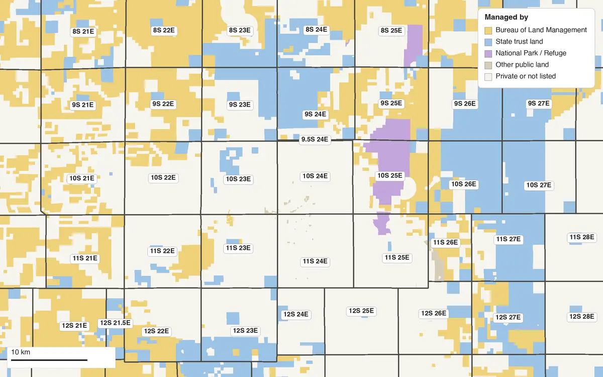
Federal agencies manage about 24.6 million acres of New Mexico, 32% of the state, mostly Bureau of Land Management land (13.5 million acres) and national forest (9.2 million). The State Land Office manages another 9 million surface acres of trust land, in every county, whose income supports public schools, hospitals and colleges. In the east especially, BLM land, trust land and private ranches lie in a patchwork, and the rules change with the owner: trust land has stricter ones than the BLM's.
GoGIS downloads that ownership map onto your iPhone or iPad, along with the BLM's township and section grid. Stand anywhere in New Mexico, tap the ground under your GPS position, and read whose land it is, the first thing to know before you pick a spot to camp, and what township, range and section you're in, with or without a signal.
What you can do with it in GoGIS
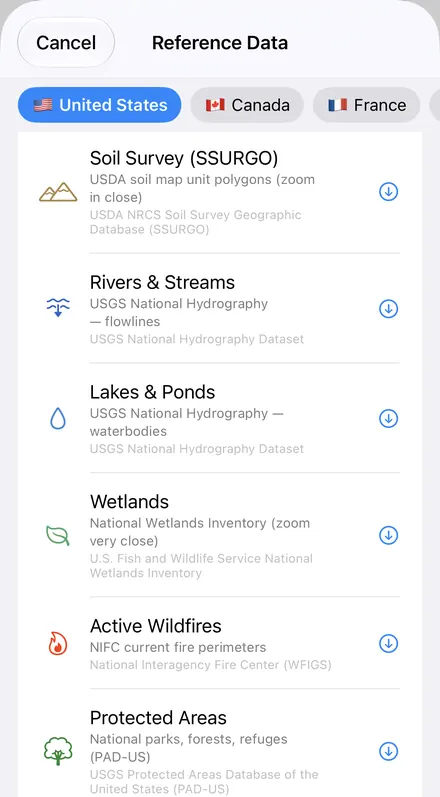
Download the data oncePick the layers you need from Reference Data. They stay on your phone and work with no signal.

Tap the map, even with no signalRead everything the publisher records about the parcel, field or area under your finger.

Photos, sketches and notesTake a picture where you stand, sketch on the map, and write down what you saw.

Your photos on the mapSee every photo where you took it, and share a PDF report of the place and your notes.
Dispersed Camping on New Mexico's Public Land
Camping outside a campground is allowed on most BLM land and national forest in New Mexico, within limits, but not on state trust land:
- BLM land in New Mexico: up to 14 days in any 28, then move at least 25 miles. Some districts set shorter limits.
- National forests set their own orders. The Gila, for one, allows 14 days in any 30. Check the forest's current order before you go.
- State trust land needs a State Land Office Recreational Access Permit, $35 a year, for recreation other than licensed hunting and fishing. Overnight camping, open fires and off-road driving aren't allowed on it, except camping by licensed hunters in designated areas.
GoGIS shows you whose land you're standing on. It doesn't show closures, fire restrictions or designated sites. Those come from the field office or the forest, and they change through the season. New to it? See how dispersed camping works on public land.
| Who manages New Mexico's public land | Acres |
|---|---|
| Bureau of Land Management | 13,491,010 |
| Forest Service (national forests) | 9,229,797 |
| Department of Defense | 1,055,589 |
| National Park Service | 472,925 |
| U.S. Fish and Wildlife Service | 332,058 |
| State Land Office (state trust land) | about 9 million |
Federal acres as of September 30, 2024, from the Congressional Research Service's Federal Land Ownership: Overview and Data (R42346). State trust land from the New Mexico State Land Office.
What GoGIS Downloads for New Mexico
- Protected Areas (PAD-US) — every piece of public land, from the U.S. Geological Survey's national inventory: who manages it (Bureau of Land Management, Forest Service, State Trust Land, U.S. Fish and Wildlife Service), the unit's name (Roswell Field Office, Bitter Lake National Wildlife Refuge) and its public access (open, restricted, closed or unknown). U.S. Geological Survey, Protected Areas Database of the United States (PAD-US). Public domain.
- PLSS Townships, Sections and Quarter-Quarters — the BLM's survey grid, labeled the way a deed reads it. Roswell is in section 4 of township 11 south, range 24 east. Bureau of Land Management, PLSS CadNSDI. Public domain. Not legal documents or land surveys.
- BLM Mining Claims and Grazing Allotments — every claim that isn't closed, by name, serial number and status, and the allotment you're standing in. More on the BLM layers.
Township and Range in New Mexico
New Mexico's townships are counted from the New Mexico Principal Meridian, established in 1855, whose meridian and base line cross in Socorro County near San Acacia. So Albuquerque is in 10N 3E, Roswell in 11S 24E and Farmington in 29N 13W.
Some of the state was never divided this way. Spanish and Mexican land grants kept their own boundaries, and around towns such as Socorro and Las Cruces the BLM's grid has no township to show. There, a legal description names the grant instead.
Deeds, oil and gas leases, mineral deeds and the BLM's General Land Office records all describe land this way, as something like the SE¼ of section 4, township 11 south, range 24 east, New Mexico Principal Meridian. With the grid downloaded, you can tap the map to read the section you're in, or find the section a document names and see where it lies against roads, rivers and today's property lines.
How to Download the Layers
- Move the map to where you're going. Search for a town, such as Roswell, or pan and zoom to the area. GoGIS downloads what's on the screen. Do this before you lose signal.
- Open Reference Data. Tap Import, then Reference Data. With the map in New Mexico, the United States datasets are listed.
- Choose Protected Areas, then PLSS Townships or PLSS Sections. Each arrives as its own layer, Protected Areas colored by who manages the land (BLM yellow, national forest green, state land blue), and the download keeps going if you switch apps.
- Go. Out of signal, your GPS position still shows on the map. Tap the ground for the manager, the unit and the section.
Next step: open the Protected Areas layer's attribute table to filter the land by manager, Bureau of Land Management only for example, or by public access, search for a unit such as Roswell Field Office, and export the list to Excel as a CSV. See the attribute table on iPhone and iPad.
Heading somewhere else? BLM land maps for Montana, Wyoming, Utah, Idaho, Arizona, Nevada, Colorado, Oregon, California and Washington. The same layers cover every state with public land: see the BLM's PLSS grid, mining claims and grazing allotments, statewide tax parcels for 19 states and DC, and offline maps for fieldwork.
Questions
Can I use it to find dispersed camping in New Mexico?
It shows where the public land is and who manages it, which is the first thing to know: most BLM land and national forest in New Mexico allows camping outside campgrounds, within the limits above. It doesn't mark campsites, closures, fire restrictions or designated sites. Those come from the BLM field office or the national forest, so check their current rules before you camp.
Does it work with no cell signal?
Yes, once the layers are downloaded. Download them at home or in town for the area you're heading to; out there, your GPS position still shows on the map, and tapping the ground tells you whose land it is and what township and section you're in.
Can I reach every piece of public land on the map?
Not necessarily. Much of New Mexico's public land lies in a patchwork with private ranches, and a parcel with no road or public land touching it may have no legal way in. The map shows who manages the land, not whether you can legally get there.
Is New Mexico's state trust land included?
Yes. Protected Areas includes New Mexico's state trust land as well as BLM land, national forests, refuges and parks. For recreation other than licensed hunting and fishing you need a State Land Office Recreational Access Permit, and overnight camping isn't allowed.
Are the township and section lines legal boundaries?
No. They're the BLM's best fit of the survey records, good for reading a legal description and finding roughly where it lies. A corner on the ground is where the survey monument is.
New Mexico's public land, in your pocket
BLM land, national forests, state trust land and the township grid, ready to download on your iPhone or iPad.
Get GoGIS on the App Store Get GoGIS on Google Play