The PLSS Grid, BLM Mining Claims & Grazing Allotments on Your iPhone & iPad
Across 30 states, land is described by the Public Land Survey System: a township and range, a section within it, and a quarter-quarter within that, so that a field becomes the SW¼ of the NE¼ of section 7, township 7 north, range 64 west. The Bureau of Land Management publishes that grid as CadNSDI. It also publishes every unpatented mining claim that isn't closed, from its Mineral & Land Records System (MLRS), refreshed daily, and the grazing allotments on the land it manages.
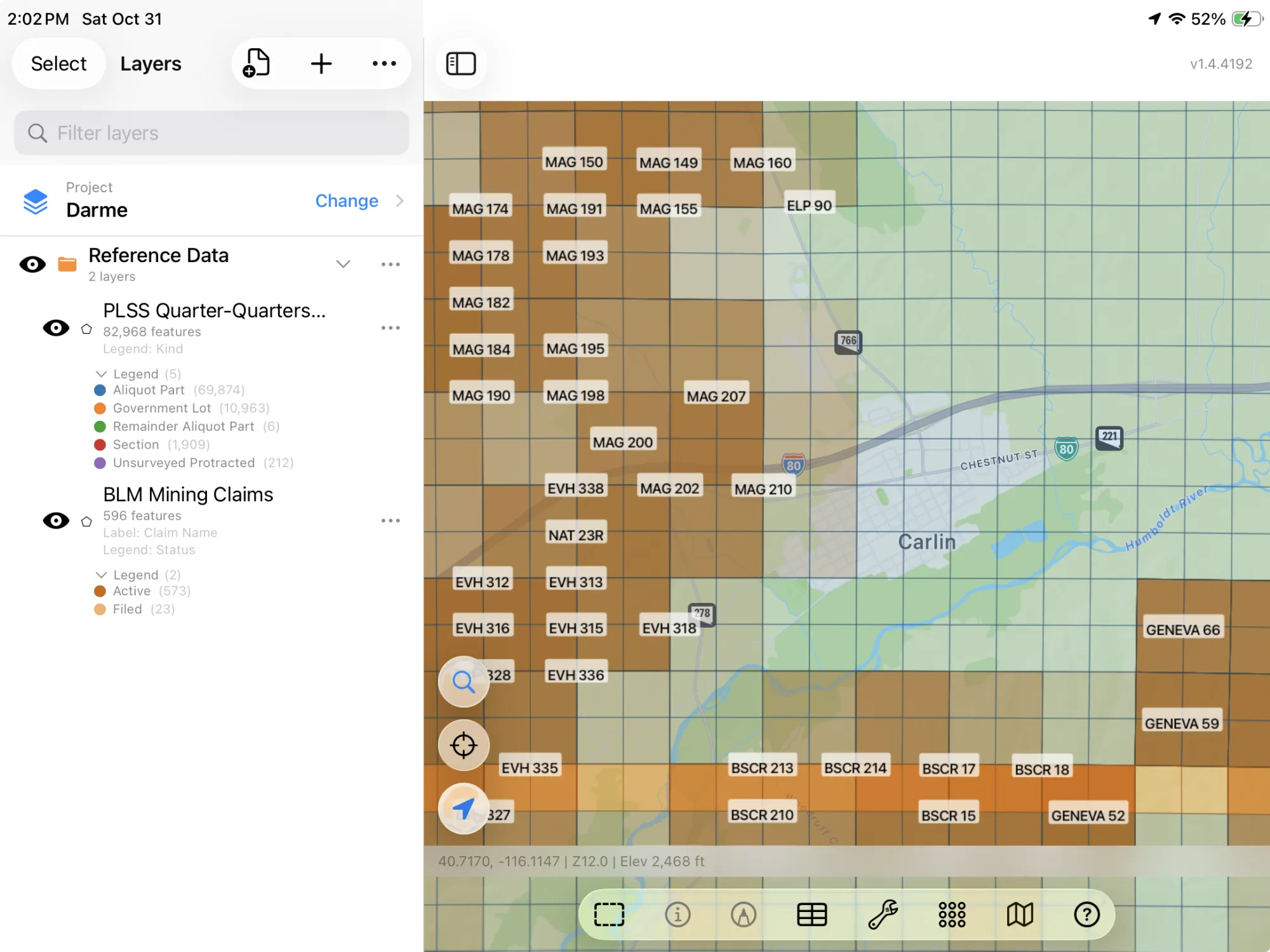
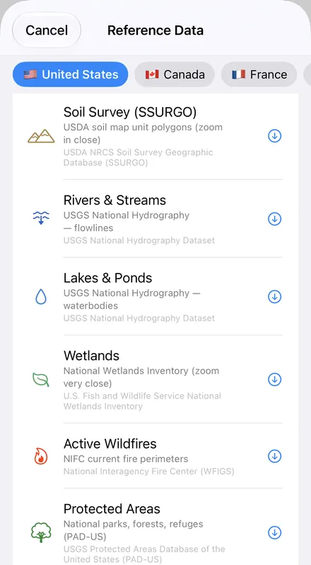
GoGIS now has all of these in the United States section of Reference Data. Move the map to your area, pick a dataset, and it downloads as a layer on your iPhone or iPad, labeled the way you'd read it on a plat.
What you can do with it in GoGIS
Download the data oncePick the layers you need from Reference Data. They stay on your phone and work with no signal.

Tap the map, even with no signalRead everything the publisher records about the parcel, field or area under your finger.

Photos, sketches and notesTake a picture where you stand, sketch on the map, and write down what you saw.

Your photos on the mapSee every photo where you took it, and share a PDF report of the place and your notes.
The Five BLM Datasets
- PLSS Townships — the township and range grid of the 30 public-land survey states: each township's label (7N 64W), its principal meridian, its state and its PLSS ID. The layer arrives labeled by township.
- PLSS Sections — the sections, numbered within their township: section number, township and range, the kind of division, state and ID. The layer arrives labeled by section number.
- PLSS Quarter-Quarters & Lots — the quarter-quarter sections (SWNE) and government lots (L 1), with their section, township, meridian, state and acres: the record acreage where the BLM has one, the mapped acreage otherwise. Where CadNSDI has no second division for a section, the section itself is included. The layer arrives labeled by part and colored by kind. Bureau of Land Management, PLSS CadNSDI. Public domain. Not legal documents or land surveys.
- BLM Mining Claims — every lode and placer claim in MLRS that isn't closed: claim name, serial number, the legacy serial from before MLRS, type, status (Active or Filed), recorded acres, location (meridian, township, range and section) and the date it was last updated. No claimants' names are published. The layer arrives colored by status, Active in dark orange and Filed in light orange, and labeled by claim name. Bureau of Land Management, MLRS mining claims (not closed). Public domain. Mapped to the quarter sections in each claim's legal description, not as staked.
- BLM Grazing Allotments — the grazing allotments on BLM land: allotment name, allotment number, acres, administering state and field office. No permittees' names. The layer arrives labeled by allotment name. Bureau of Land Management, grazing allotments. Public domain.
How Mining Claims Are Drawn
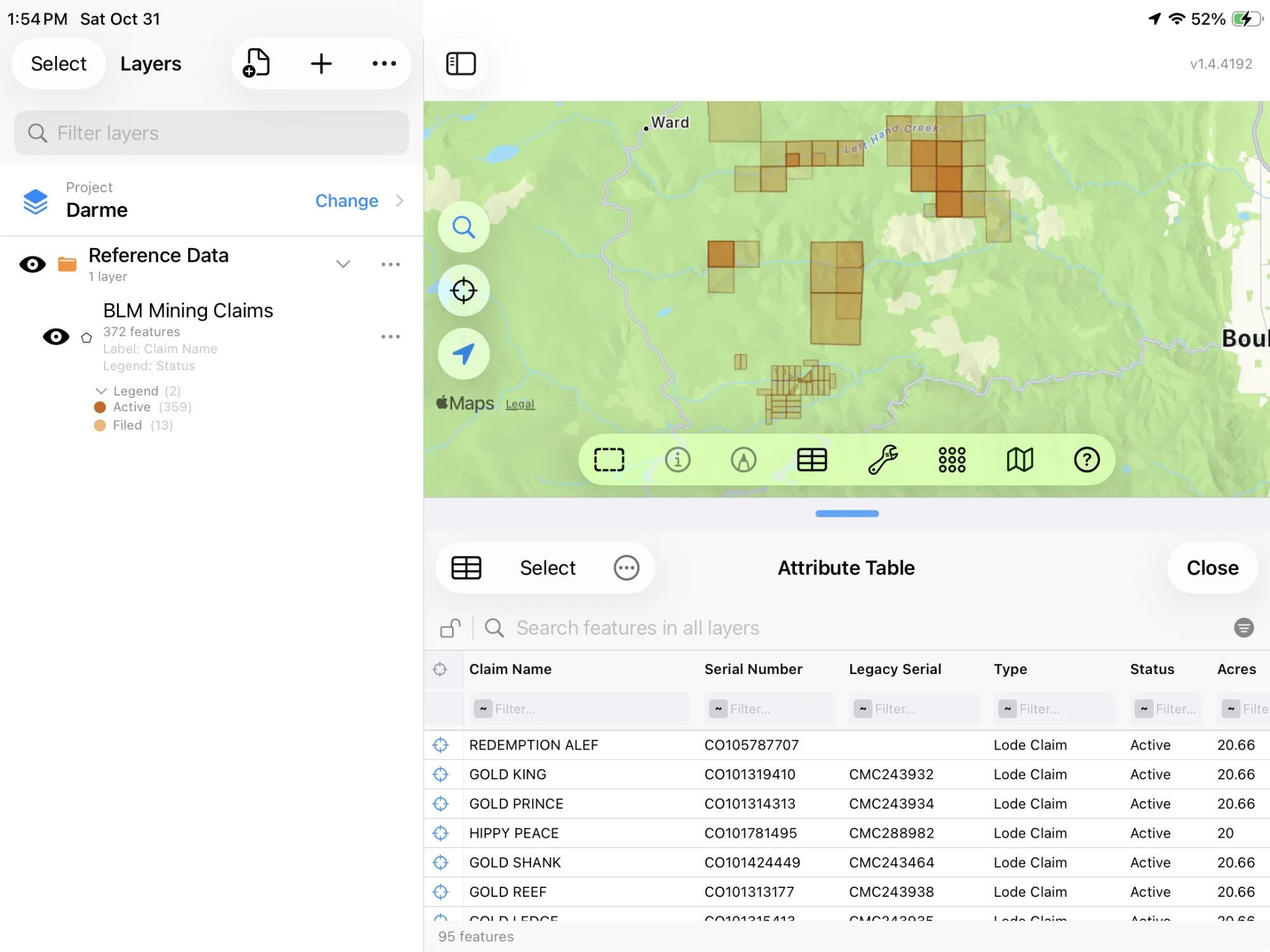
A mining claim is staked on the ground, but MLRS records it by its legal description: the quarter sections it lies in. The BLM maps each claim as those quarter sections, so a 20-acre lode claim shows as a 160-acre square, and claims that share a quarter section lie on top of one another. Read the layer as which quarter sections have claims in them, then tap a claim for its serial number and look it up in MLRS for the case record.
How to Download the Layers
- Move the map to your area. Search for a town or a place, or pan and zoom to the land you want. GoGIS downloads what's on the screen. Quarter-quarters are small, so zoom in to a few townships for those.
- Open Reference Data. Tap Import, then Reference Data. With the map in the US, the United States datasets are the ones listed.
- Choose a dataset. The download keeps going if you switch apps or the screen would otherwise lock, and progress shows on the map. The BLM's servers count what's in the area first; if there are a great many features, GoGIS tells you how many and asks before it downloads them.
- Read the map. Townships, sections and quarter-quarters arrive labeled; claims by name and colored by status. Tap anything to see everything about it.
Put the Layers to Work
- Work through the claims in a table. In the mining claims' attribute table, filter by status or claim type, sort by the date last updated, sum the recorded acres with a column summary, and export the list as a CSV that Excel opens. See the attribute table on iPhone and iPad.
- Know where you stand in the grid. With your GPS position on the map, read off the township, section and quarter-quarter you're in, offline once the layers are downloaded, and write a legal description the way the records do.
- Check for claims before you prospect. See which quarter sections already hold active or filed claims, with their serial numbers to look up.
- Find the allotment you're on. Tap the ground under you for the allotment's name and number and the field office that runs it.
- Combine them with your own data. Lay state parcels or your own boundaries over the grid, or use Intersect to cut a pasture by quarter-quarter.
- Export or print. Share any layer as a Shapefile, GeoPackage, KML, GeoJSON or CSV, or print a PDF map. The BLM's credit goes on the print and with the export.
Reading a deed or a lease? The section, township and range finder walks through a real legal description. Claims in detail: BLM mining claims from MLRS.
Public land by state: BLM land, national forest and state trust land, with township and range, for Montana, Wyoming, Utah, Idaho, New Mexico, Arizona, Nevada, Colorado, Oregon, California and Washington. Going camping? See dispersed camping on public land.
More US reference data? Reference Data also has statewide tax parcels for 19 states and DC, SSURGO soils, FEMA flood zones, rivers and wetlands, and OpenStreetMap roads, rivers, buildings and land use anywhere.
Questions
Which states does the PLSS grid cover?
The 30 public-land survey states, from Ohio, Alabama and Florida west to the Pacific, and Alaska. The original thirteen colonies, Texas and the other states laid out by metes and bounds weren't surveyed this way, so the grid has nothing there.
Are the PLSS lines legal boundaries?
No. CadNSDI is the BLM's best fit of the survey records, and the BLM says so on every layer: not legal documents or land surveys. A corner on the ground is where the survey monument is.
Are the mining claims drawn where they're staked?
No. Each claim is drawn as the quarter sections its legal description names, so it covers more ground than was staked and claims overlap. Tap a claim for its serial number and check MLRS for the case record.
Do the layers show claimants or permittees?
No. The BLM's public layers carry no claimants' or permittees' names, and GoGIS doesn't ask for any.
Do I need desktop GIS software, an account or an API key?
No. GoGIS downloads from the BLM's open services. There's no key, no account and nothing to unzip.
The public land grid, in your pocket
PLSS townships, sections and quarter-quarters, BLM mining claims and grazing allotments, ready to download on your iPhone or iPad.
Get GoGIS on the App Store Get GoGIS on Google Play