Bulgaria's Cadastral Map on Your iPhone & iPad
Bulgaria's cadastral map is kept by the Geodesy, Cartography and Cadastre Agency (Агенция по геодезия, картография и кадастър, AGCC or АГКК). Its portal, KAIS (КАИС, the cadastral administrative information system), publishes the map as open data, one file of land parcels (поземлени имоти) for each of the country's settlements, free to reuse with AGCC's credit.
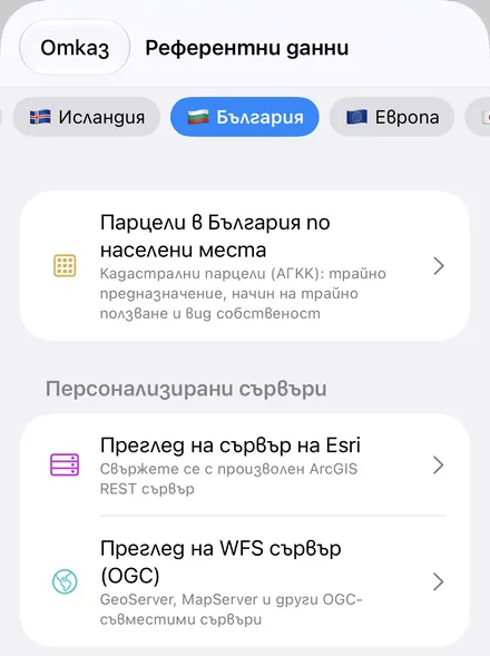
GoGIS has a Bulgaria section in Reference Data with Bulgaria Parcels by Settlement. Tick the villages and towns you need, all 5,128 of them are listed, and each downloads as a layer on your iPhone or iPad: every parcel with its cadastral identifier, land category, land use and type of ownership, colored by land category, ready to read, search, combine with your own data and take into the field without a signal. Columns are in Bulgarian when the app is, in English otherwise.
What you can do with it in GoGIS
Download the data oncePick the layers you need from Reference Data. They stay on your phone and work with no signal.

Tap the map, even with no signalRead everything the publisher records about the parcel, field or area under your finger.

Photos, sketches and notesTake a picture where you stand, sketch on the map, and write down what you saw.

Your photos on the mapSee every photo where you took it, and share a PDF report of the place and your notes.
What Each Parcel Carries
GoGIS keeps nine of the file's columns and leaves out the codes and duplicates:
| Column | In Bulgarian | What it tells you |
|---|---|---|
| Cadastral ID | Идентификатор | The parcel's cadastral identifier, the number that names it in every register: 10422.24.30 is parcel 30 in cadastral region 24 of Velikovo, whose EKATTE code (the national settlement code) is 10422. |
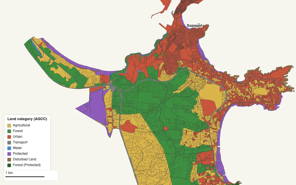
| Land Category | Трайно предназначение | The land's permanent purpose under the Cadastre Act: agricultural, forest, urban, transport, water, protected or disturbed land. The layer is colored by it (below). |
| Land Use | Начин на трайно ползване | How the land is used within its category: Arable field (Нива), Meadow, Vineyard, Broadleaf forest, Low-rise buildings (up to 10 m), Secondary street. GoGIS has English for 212 of AGCC's uses; any other stays in Bulgarian. |
| Ownership Type | Вид собственост | Who holds the land, as a kind of ownership, never a person: private, municipal or state, public or private (below). |
| Locality | Местност | The traditional name of the place the parcel lies in, outside the built-up area: the names fields and slopes have had for generations. |
| Address | Адрес | The parcel's address: a street and number in a town, often just the village outside one. |
| Settlement | Населено място | The village or town whose land it is. |
| Area (m²) | Площ (м²) | The parcel's area in the cadastral map, in whole square metres. |
| Approved by Order | Одобрена със заповед | The AGCC order that approved the cadastral map for the area, with its date: РД-18-238/30.01.2018 г. |
No owner is published, and none comes. The ownership type is a category only, which is why AGCC can publish it as open data.
Land Categories and Their Colors
The colors are the app's. The counts are Sozopol's, from its file of 20 October 2026: 7,315 parcels, from the old town and its beaches to the forests and fields inland.
| Land category | In Bulgarian | Sozopol |
|---|---|---|
| Agricultural | Земеделска | 2,461 |
| Forest | Горска | 967 |
| Urban | Урбанизирана | 3,678 |
| Transport | Територия на транспорта | 55 |
| Water | Територия, заета от води и водни обекти | 15 |
| Protected | Защитена | 116 |
| Disturbed Land | Нарушена | 22 |
| Forest (Protected) | Горска територия - защитена | 1 |
| Urban (Protected) | Урбанизирана територия - защитена | – |
| Agricultural (Protected) | Земеделска територия - защитена | – |
A settlement's land can be mostly one category. In Bansko, 212 parcels of protected land cover 10,240 ha, more than two thirds of the town's 14,885 ha, up into the Pirin mountains; in Sofia's Triaditsa district, 5,268 of 5,538 parcels are urban.
Ownership Types
The type of ownership tells you whether land is private, the municipality's or the state's. Public state or municipal property serves public use, such as roads, rivers, parks and schools, and can't be sold; private state or municipal property is held the way anyone holds land, and can be leased or sold. In Sozopol, 5,079 of the 7,315 parcels are private.
| Ownership type | In Bulgarian |
|---|---|
| Private | Частна |
| Municipal (public) | Общинска публична |
| Municipal (private) | Общинска частна |
| State (public) | Държавна публична |
| State (private) | Държавна частна |
| Exclusive state property | Изключителна държавна собственост |
| Co-ownership | Съсобственост |
| Private, civic organisations | Частна обществени организации |
| Private, religious organisations | Частна религиозни организации |
| Private, foreign persons and companies | Частна чужди физически и юридически лица |
| Commercial | Стопанска |
| Civic organisations | Обществени организации |
| Managed by the municipality | Стопанисвано от общината |
| Private, cooperative | Частна кооперативна |
| Religious organisations | Религиозни организации |
| Foreign persons and companies | Чужди физически и юридически лица |
| Cooperative | Кооперативна |
How to Download Parcels by Settlement
- Move the map to your area. Search for a town or an address, or pan to the land you want: the settlements on the map are listed first.
- Open Reference Data. Tap Import, then Reference Data. The row of countries along the top opens on the one the map is showing, so with the map in Bulgaria, the Bulgaria section is the one listed. Choose Bulgaria Parcels by Settlement.
- Tick one or more settlements. The ones on the map come first, under On the Map, the rest under Elsewhere. Each row has the name in Latin letters and in Cyrillic with its municipality, Velikovo · Великово (General Toshevo), so Settlement or municipality finds Velikovo, Великово or the municipality's name, in either alphabet.
- Tap Download. Each settlement becomes its own layer, such as Velikovo · Великово Parcels, colored by land category. GoGIS asks the portal for one file at a time, a few seconds apart, as the portal requires, and a settlement you already have is marked Already downloaded.
Next step: open a settlement's attribute table to filter the parcels by Land Category or Ownership Type, total their Area (m²) with a column summary, and export the list to Excel as a CSV. See the attribute table on iPhone and iPad.
Files run from small to large: Velikovo, a village in Dobrich province, is 119 kB and 856 parcels; Plovdiv, the country's second city, is 9.2 MB and 38,797 parcels. GoGIS reads a big file in pieces and keeps only the nine columns, so a city fits comfortably on a phone.
Sofia comes a district at a time: its 24 districts (райони), from Sredets and Triaditsa to Pancharevo and Novi Iskar, are listed as гр. София, район Триадица and so on, and the villages of Stolichna municipality as villages of their own.
Every Oblast
KAIS sorts its files into the 28 oblasts (provinces) and their 265 municipalities. Each oblast has a page of its own, in Bulgarian, with its municipalities and settlements and a map of one settlement's parcels: all 28 oblasts. The names below link straight to them.
| Oblast (province) | Municipalities | Settlements |
|---|---|---|
| Blagoevgrad (област Благоевград) | 14 | 266 |
| Burgas (област Бургас) | 13 | 248 |
| Dobrich (област Добрич) | 8 | 215 |
| Gabrovo (област Габрово) | 4 | 326 |
| Haskovo (област Хасково) | 11 | 260 |
| Kardzhali (област Кърджали) | 7 | 453 |
| Kyustendil (област Кюстендил) | 9 | 182 |
| Lovech (област Ловеч) | 8 | 110 |
| Montana (област Монтана) | 11 | 129 |
| Pazardzhik (област Пазарджик) | 12 | 116 |
| Pernik (област Перник) | 6 | 170 |
| Pleven (област Плевен) | 11 | 123 |
| Plovdiv (област Пловдив) | 18 | 212 |
| Razgrad (област Разград) | 7 | 103 |
| Ruse (област Русе) | 8 | 83 |
| Shumen (област Шумен) | 10 | 149 |
| Silistra (област Силистра) | 7 | 118 |
| Sliven (област Сливен) | 4 | 110 |
| Smolyan (област Смолян) | 10 | 185 |
| Sofia City (София (столица)) | 1 | 62 |
| Sofia Province (Софийска област) | 22 | 261 |
| Stara Zagora (област Стара Загора) | 11 | 205 |
| Targovishte (област Търговище) | 5 | 190 |
| Varna (област Варна) | 12 | 158 |
| Veliko Tarnovo (област Велико Търново) | 10 | 322 |
| Vidin (област Видин) | 11 | 140 |
| Vratsa (област Враца) | 10 | 123 |
| Yambol (област Ямбол) | 5 | 109 |
Credit and How Current It Is
AGCC allows its open data to be reused, commercially too, as long as each use credits it in these exact words, and GoGIS puts them on every layer with the day you downloaded it:
Източник на данните – Агенция по геодезия, картография и кадастър (АГКК). КАИС, отворени данни, изтеглени на [download date].
The credit goes on prints and with exports. AGCC refreshes the files oblast by oblast: on 12 November 2026, the 28 oblasts' files on the portal were dated between 15 October 2026 and 11 November 2026. Download again to bring a layer up to date.
Put the Layers to Work
- Find a parcel in the field. Stand on the land with your GPS position on the map and tap: the identifier, category and use are there, with or without a signal once the layer is downloaded.
- Find a parcel by its identifier. Open the layer's table and search for the cadastral ID, such as 10422.24.30, then go to it on the map.
- Combine them with your own data. Draw your own points, lines and areas, take photos and fill in forms on top of the parcels, or use Intersect to cut your survey areas by parcel.
- Export or print. Share any layer as a Shapefile, GeoPackage, KML, GeoJSON or CSV, or print a PDF map, with AGCC's credit.
A cadastral map is not a survey, and a layer in an app is not an official sketch (скица). For a boundary on the ground, or a document you need for a sale or a permit, AGCC's official documents and a licensed surveyor have the last word.
More for Bulgaria. Reference Data also has Europe-wide nationally designated protected areas, 1,097 of them in Bulgaria, and Natura 2000 sites, with OpenStreetMap's roads, rivers and buildings anywhere. See Reference Data by country for the rest of Europe.
Questions
Do the layers show owners?
No. AGCC publishes no owners in its open data. The ownership type says what kind of ownership it is (private, municipal, state), never whose.
Why does it come a settlement at a time?
That's how AGCC publishes its open data: one file of parcels for each settlement's land, and for Sofia one for each district. GoGIS lists all 5,128, the ones on your map first.
How do I find a parcel by its cadastral identifier?
Download the settlement (the first five digits of the identifier are its EKATTE code), open the layer's table and search for the identifier.
How current are the parcels?
As current as AGCC's file on the day you download it. AGCC refreshes the files oblast by oblast, and the layer's credit carries the date you downloaded it.
Is the cadastral map a survey?
No. Its boundaries and areas are the cadastral map's. For a boundary on the ground or a legal document, AGCC's official documents and a licensed surveyor have the last word.
Do I need an account, a key or desktop GIS software?
No. GoGIS downloads AGCC's open data files directly from KAIS. There's no key, no account and nothing to unzip.
Bulgaria's cadastre, in your pocket
AGCC's cadastral map, a settlement at a time, ready to download on your iPhone or iPad.
Get GoGIS on the App Store Get GoGIS on Google Play