Colombia's Parcels & Mineral Deposits on Your iPhone & iPad
The Instituto Geográfico Agustín Codazzi (IGAC) gathers the cadastre of every Colombian municipality into one open base, SINIC, refreshed every two months: more than eleven million parcels, rural and urban, each with its national cadastral number and what it is used for. The Servicio Geológico Colombiano (SGC) publishes its database of the country's mineral deposits, from producing mines to prospects and occurrences.
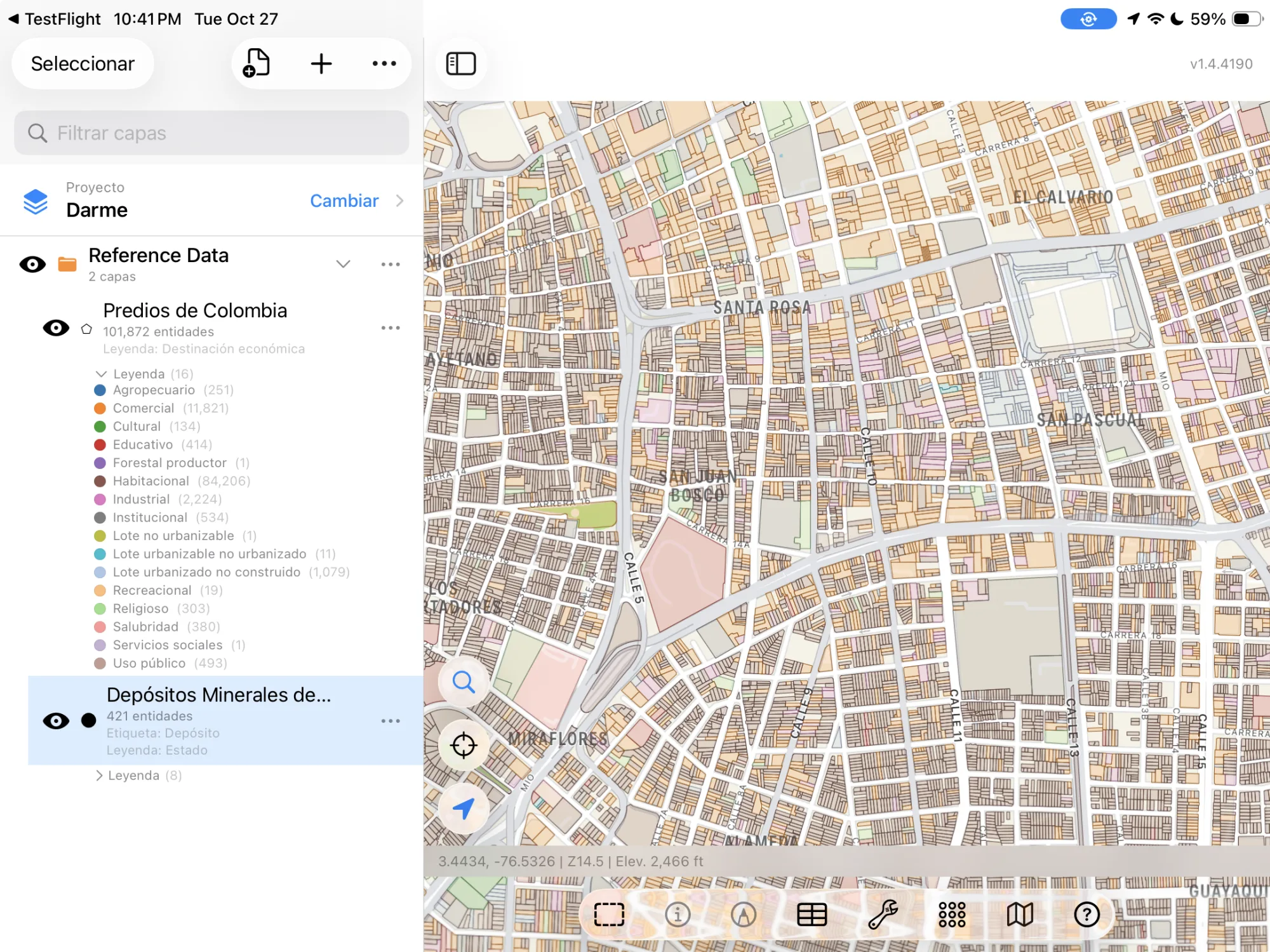
GoGIS now has a Colombia section in Reference Data. Move the map to your area, pick a dataset, and it downloads as a layer on your iPhone or iPad, with areas in hectares and the values in plain words: in Spanish when the app is in Spanish, in English otherwise.
The Two Colombian Datasets
- Colombia Parcels — IGAC's open cadastral base: each parcel's national cadastral number, its department and municipality, whether it is rural or urban, its economic use (Cropping, Farming, Livestock, Residential, Public use), its land type (Private, Public, presumed unallocated), the right held to it (Ownership, Possession, Occupation), whether it is a condominium unit, and its area in hectares, measured from its outline. No owners' names. The layer arrives colored by economic use. Fuente: Instituto Geográfico Agustín Codazzi (IGAC) – SINIC, Datos Abiertos Catastrales. CC BY-SA 4.0.
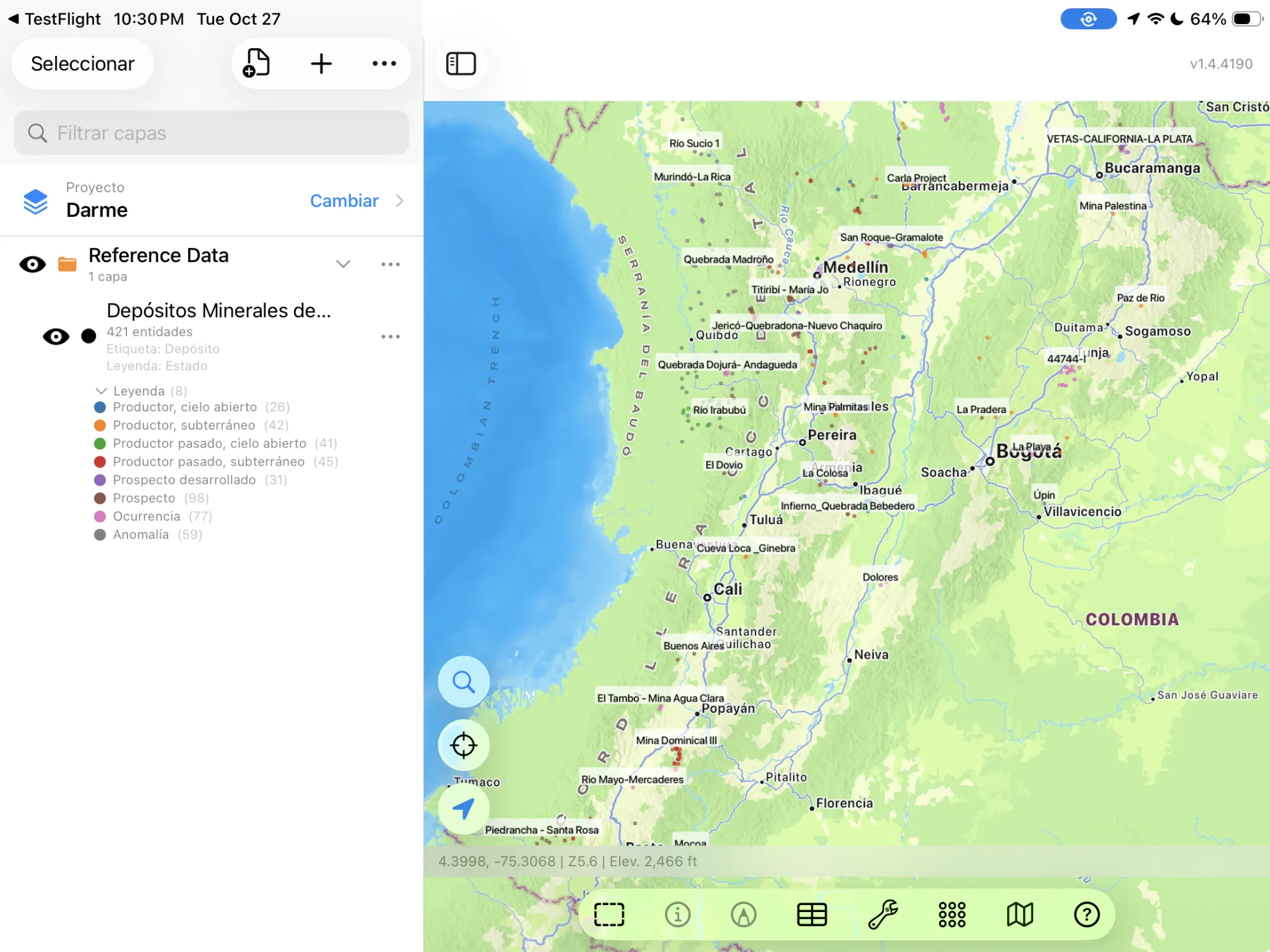
- Colombia Mineral Deposits — The Servicio Geológico Colombiano's mineral deposits: 422 mines, prospects and occurrences, each with its name, its status (Producer, open pit, Past producer, underground, Prospect, Occurrence), its elements (Gold, Silver, Copper), the deposit class (Porphyry, Epithermal, Placer) and type, where it is, the resource or reserve reported for it, and a description. The layer arrives colored by status. Fuente: Servicio Geológico Colombiano – Depósitos Minerales de Colombia. CC BY 4.0.
How to Download the Layers
- Move the map to your area. Search for a town or an address, or pan and zoom to the land you want. GoGIS downloads what's on the screen.
- Open Reference Data. Tap Import, then Reference Data. The row of countries along the top opens on the one the map is showing, so with the map in Colombia, the Colombia datasets are the ones listed.
- Choose a dataset. The download keeps going if you switch apps or the screen would otherwise lock, and progress shows on the map. IGAC's and SGC's servers count what's in the area first; if there are a great many features, GoGIS tells you how many and asks before it downloads them. IGAC's server is not fast, about a thousand parcels every ten seconds, so a whole city takes a while.
- Read the map. Parcels arrive colored by economic use, deposits labeled by name. Tap anything to see everything about it.
Put the Layers to Work
- See how a district's land is used. The parcels' economic use shows the cropping, livestock and agroforestry land around you, and which parcels are public or unallocated state land.
- Find a parcel's cadastral number. Tap a parcel for its 30-digit national cadastral number, the key to its records at the municipality and the registry.
- Combine them with your own data. Use Intersect to cut your fields by the parcels, or buffer a deposit and see which parcels are near it.
- Export or print. Share any layer as a Shapefile, GeoPackage, KML, GeoJSON or CSV, or print a PDF map. The source credit goes on the print and with the export.
Elsewhere in South America? Reference Data also has Brazil's certified rural parcels and mining rights, Córdoba's soil map, and OpenStreetMap roads, rivers, buildings and land use anywhere.
Questions
Do the parcels show the owners?
No. IGAC's open cadastral base has no owners' names.
How current are the parcels?
Each municipality's cadastral office reports to IGAC every two months, and GoGIS downloads the base as it is on the day you download.
What does CC BY-SA mean for my maps?
IGAC's licence lets you use, change and share the parcels, commercially too, as long as you credit IGAC and share what you make from them under the same licence. GoGIS keeps the credit with the layer, so it goes on your prints and exports.
Do I need desktop GIS software, an account or an API key?
No. GoGIS downloads from IGAC's and SGC's open services. There's no key, no account and nothing to unzip.
Colombia's cadastre, in your pocket
IGAC's parcels and SGC's mineral deposits, in Spanish or English, ready to download on your iPhone or iPad.
Get GoGIS on the App Store