Brazil's Rural Parcels & Mining Rights on Your iPhone & iPad
Since 2013, every rural property in Brazil that is sold, split or registered has to be georeferenced and certified by INCRA, the national land reform institute, in its SIGEF land management system. More than two million certified parcels are published every day, each with its name (usually the farm's, Fazenda Santa Anastácia), its status and its SNCR property code. The Agência Nacional de Mineração (ANM) publishes every mining right and application in the country in SIGMINE.
GoGIS now has a Brazil section in Reference Data. Move the map to your area, pick a dataset, and it downloads as a layer on your iPhone or iPad, with areas in hectares and the values in plain words: in Portuguese when the app is in Portuguese, in English otherwise.
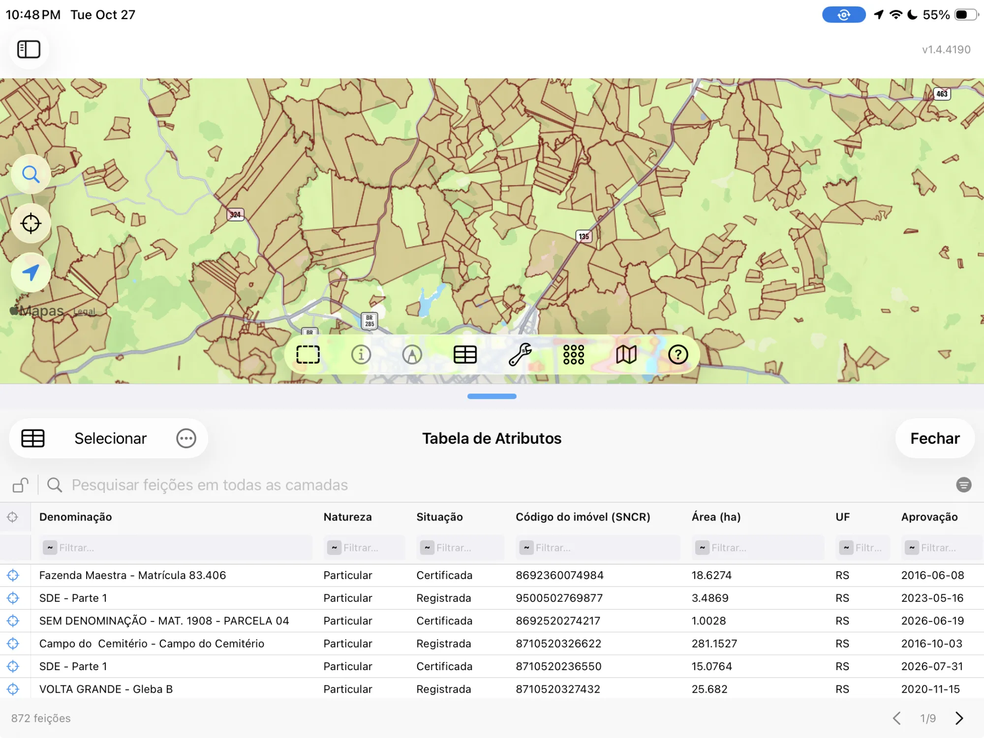
The Two Brazilian Datasets
- Brazil Rural Parcels (SIGEF) — INCRA's certified rural parcels: each parcel's name, its type (Private, Settlement Plot, Public Land Tract, Conservation Unit), its status (Certified, Registered, Being titled), its SNCR property code, its area in hectares, its state, the day it was approved and its SIGEF parcel code. No owners' names. The layer arrives colored by type and labeled by name. Fonte: INCRA – Sistema de Gestão Fundiária (SIGEF). CC BY.
- Brazil Mining Processes (ANM) — ANM's SIGMINE: every active mining right and application, with its process number (866.136/2001), its phase (Exploration Permit, Mining Concession, Licence, Artisanal Mining Permit, Open for Reoffer), the substance (Areia, Ouro, Minério de ferro), what it is for (Construction, Industrial, Fertilizers), its area, state and latest event. Titleholders' names are left out. The layer arrives colored by phase. Fonte: Agência Nacional de Mineração (ANM) – SIGMINE. CC BY.
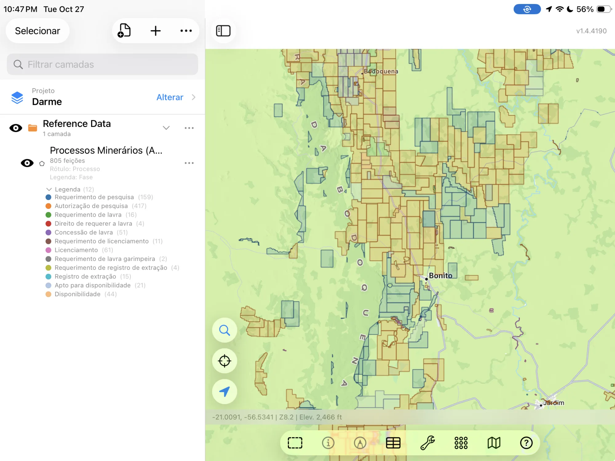
How to Download the Layers
- Move the map to your area. Search for a town or an address, or pan and zoom to the land you want. GoGIS downloads what's on the screen.
- Open Reference Data. Tap Import, then Reference Data. The row of countries along the top opens on the one the map is showing, so with the map in Brazil, the Brazil datasets are the ones listed.
- Choose a dataset. The download keeps going if you switch apps or the screen would otherwise lock, and progress shows on the map. INCRA's and ANM's servers count what's in the area first; if there are a great many features, GoGIS tells you how many and asks before it downloads them.
- Read the map. Parcels arrive labeled by name, mining rights by process number. Tap anything to see everything about it.
Put the Layers to Work
- Check a farm's certification. Tap a parcel for its status, its SNCR code and its certified area before you buy, lease or finance it.
- See the mining rights around you. Lay SIGMINE over the parcels to see which properties have an exploration permit or a concession on them, and for what.
- Combine them with your own data. Use Intersect to cut your fields by the certified parcels, or buffer a river and see which parcels it touches.
- Export or print. Share any layer as a Shapefile, GeoPackage, KML, GeoJSON or CSV, or print a PDF map. The source credit goes on the print and with the export.
Elsewhere in South America? Reference Data also has Colombia's national cadastre and mineral deposits, Córdoba's soil map, and OpenStreetMap roads, rivers, buildings and land use anywhere.
Questions
Does SIGEF have every farm in Brazil?
No. SIGEF holds the parcels certified since 2013, when georeferencing became required for selling, splitting or registering rural land. A property that hasn't changed hands since may not be certified yet, and urban lots aren't in it.
Do the parcels or mining rights show the owners?
No. INCRA's open layer has no owners' names, and GoGIS doesn't download the titleholder's name from SIGMINE, since some titleholders are people.
Is the data in Portuguese or English?
Both. With GoGIS in Portuguese, the columns, the values and the legend are in Portuguese. In any other language they're in English. Farm names and substances stay as INCRA and ANM write them.
Do I need desktop GIS software, an account or an API key?
No. GoGIS downloads from INCRA's and ANM's open services. There's no key, no account and nothing to unzip.
Brazil's certified parcels, in your pocket
INCRA's rural parcels and ANM's mining rights, in Portuguese or English, ready to download on your iPhone or iPad.
Get GoGIS on the App Store