Dispersed Camping Map, Offline: Find BLM and National Forest Land on Your iPhone & iPad
Dispersed camping means camping outside a developed campground: no hookups, no tables, usually no fee. It's allowed on most BLM land and in most national forests, within limits. The hard part is knowing whose land you're on. Out West, BLM land, national forest, state trust land and private ranches meet with no fence or sign between them, and there's often no cell signal to check.
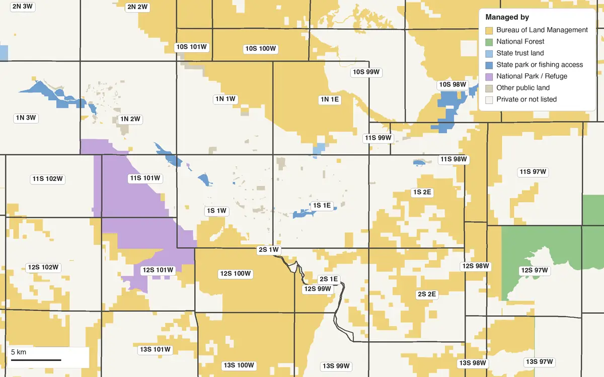
Campsite lists show the spots other people found. A land map shows every acre you could use, and whose rules apply there. GoGIS downloads the public land map for the area you're heading to onto your iPhone or iPad. Out there, tap the ground under your GPS position and it tells you who manages it, BLM, Forest Service, state or private, and the unit's name, with no signal.
What you can do with it in GoGIS
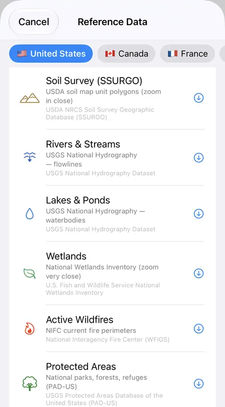
Download the data oncePick the layers you need from Reference Data. They stay on your phone and work with no signal.

Tap the map, even with no signalRead everything the publisher records about the parcel, field or area under your finger.

Photos, sketches and notesTake a picture where you stand, sketch on the map, and write down what you saw.

Your photos on the mapSee every photo where you took it, and share a PDF report of the place and your notes.
Whose Land Is It? That Decides the Rules
| Who manages it | Dispersed camping | Typical rules |
|---|---|---|
| Bureau of Land Management | Generally yes | Usually up to 14 days in any 28, then move 25 to 30 miles. Limits vary by state and field office. |
| National forest | Generally yes | Each forest's order sets the limit: 16 days at one site in Montana's forests, 14 in Idaho's. Drive only on roads shown on the forest's MVUM. |
| Bureau of Reclamation | Yes, unless posted | Up to 14 days in any 30, then move at least 10 miles. |
| Wilderness | On foot | No motor vehicles or bikes. |
| National park | Designated sites only | Backcountry camping usually needs a permit. |
| Army Corps of Engineers | Designated sites only | Up to 14 days in any 30 at one project. |
| Wildlife refuge | Rarely | Only a few refuges allow camping at all. |
| State trust land | Depends on the state | Open within limits in Utah, Idaho and Montana; permit and 14 days a year in Arizona; no overnight camping on New Mexico's or Wyoming's; closed in Colorado unless enrolled in the state's access program. |
| Private land | Only with permission | Ask the owner. |
Sources: the BLM's camping guidance; 36 CFR 261.58 and the Northern Region's camping order (Forest Service); 43 CFR 423.33 (Reclamation); 36 CFR 293.6 (wilderness); 36 CFR 2.10 (parks); 36 CFR 327.7 (Army Corps); 50 CFR 26.21 (refuges); the state land offices of each state. Rules change: check the managing office before you go.
Rules That Apply Almost Everywhere
- Stay limits. After the limit, move on, often 25 miles or more on BLM land. The exact numbers are set by each BLM state office and each national forest.
- Stay on open roads. On BLM land, camp within 150 feet of a designated route. In a national forest, drive only on roads shown on its MVUM, and off the road only inside a marked dispersed camping corridor.
- Keep back from water. 200 feet on BLM land. National forests set 100 to 200 feet; 150 feet in California's forests.
- Away from developed sites. The BLM asks you not to camp within a mile of campgrounds, trailheads or picnic areas, and many forests don't allow it near them either.
- Fire. Restrictions change through the season; check them before you light anything, and use an existing fire ring or a fire pan.
- Leave nothing. Pack out all trash. Bury human waste 6 to 8 inches deep, at least 200 feet from water and trails, or pack it out.
How to Find a Spot with GoGIS
- Before you lose signal, move the map to where you're heading. GoGIS downloads what's on the screen.
- Open Reference Data: tap Import, then Reference Data, and choose Protected Areas. Add PLSS Townships or Sections if you want the survey grid too.
- Read the colors, then tap. Public land arrives colored by who manages it: BLM land yellow, national forest green, state land blue. Tap any piece for the manager, the unit's name (a field office, a national forest) and its public access: open, restricted, closed or unknown.
- Check that unit's rules: the field office's page or the forest's current order and its MVUM.
- Out there, your GPS position shows on the map with no signal, so you know when you've crossed onto public land and when you've left it.
Next step: in the Protected Areas layer's attribute table, filter the land by public access to keep the open units, search for a field office or a national forest by name, and export the list to Excel as a CSV. See the attribute table on iPhone and iPad.
Dispersed Camping by State
Each state has its own stay limits, forest orders and state trust land rules. These pages list them, with a map of the public land around one town: Colorado, California, Arizona, Utah, Washington, Oregon, Montana, Idaho, New Mexico, Nevada and Wyoming.
More for public land: the BLM's PLSS grid, mining claims and grazing allotments, finding a section from a legal description and offline maps for fieldwork.
Questions
Does GoGIS show where I can camp?
No. It shows who manages the land you're on and its public access status, from the U.S. Geological Survey's PAD-US. It doesn't mark campsites, closures, fire restrictions or the roads you may drive. Those come from the BLM field office or the national forest, so check their current rules before you camp.
Does it work with no cell signal?
Yes, once the layers are downloaded. Download them for the area you're heading to while you still have a signal. Out there, your GPS position shows on the map, and tapping the ground tells you whose land it is.
Is dispersed camping free?
There's usually no fee on BLM land or in a national forest. Some places need a permit, such as the BLM's Long-Term Visitor Areas near Quartzsite and Yuma, and most state trust land.
What is an MVUM?
A Motor Vehicle Use Map: the free map each national forest publishes of the roads and trails open to vehicles. It also shows the corridors where you may drive off the road to a dispersed campsite. If a forest road isn't on it, you can't drive it.
Can I camp on any public land the map shows?
Not necessarily. Some of it is closed, or has no road or public land touching it, so there's no legal way in. National parks, wildlife refuges and most state trust land have their own, stricter rules. The map tells you whose rules to check.
Your public land map, in your pocket
BLM land, national forests and state trust land, ready to download on your iPhone or iPad before you lose signal.
Get GoGIS on the App Store Get GoGIS on Google Play