Latvia's Field Blocks, Crops & Cadastral Parcels on Your iPhone & iPad
Latvia's Rural Support Service, the Lauku atbalsta dienests (LAD), keeps the country's field blocks (lauku bloki) and every field farmers declare for area payments, with its crop. The State Land Service, the Valsts zemes dienests (VZD), keeps the cadastre: every land parcel (zemes vienība) with its cadastral designation. Both publish them as open data.
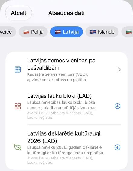
GoGIS has a Latvia section in Reference Data with all three. Move the map to your area and pick a dataset, or pick a municipality for its parcels; each downloads as a layer on your iPhone or iPad that you can read, search, combine with your own data and take into the field without a signal. Columns are in Latvian when the app is, in English otherwise.
What you can do with it in GoGIS
Download the data oncePick the layers you need from Reference Data. They stay on your phone and work with no signal.

Tap the map, even with no signalRead everything the publisher records about the parcel, field or area under your finger.

Photos, sketches and notesTake a picture where you stand, sketch on the map, and write down what you saw.

Your photos on the mapSee every photo where you took it, and share a PDF report of the place and your notes.
The Three Latvian Datasets
- Latvia Field Blocks (LAD) — the agricultural field blocks: each block's number, its area in hectares and the date it last changed. The layer arrives labeled by block number. Avots: Lauku atbalsta dienests (LAD), Lauku reģistrs.
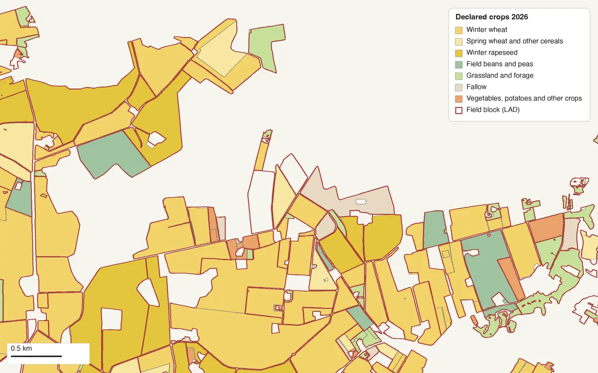
- Latvia Declared Crops 2026 (LAD) — the fields farmers declared for 2026: each field's crop, crop code, declared area in hectares and claim year. In any app language but Latvian, GoGIS gives every crop its English name from a table of all 179 crop codes in this year's declarations, and keeps LAD's Latvian name in a column of its own: Winter wheat beside Kvieši, ziemas. No farmer's name; the layer has none. It arrives colored and labeled by crop. Avots: Lauku atbalsta dienests (LAD), Lauku reģistrs.
- Latvia Parcels by Municipality — the VZD's cadastral parcels, a whole municipality at a time: each parcel's cadastral designation, whether it's surveyed, allocated or planned, its area on the map in square metres and the date its boundary was last updated. Owners are not published. The layer arrives colored by status. © Valsts zemes dienests, Kadastra informācijas sistēmas atvērtie dati (CC BY 4.0)
Around Jelgava the declared fields show what Zemgale grows: in a 6 by 4.5 km area south-west of the city, 80 of the 195 fields were winter wheat, 37 permanent grassland and 21 winter rapeseed, with field beans, fallow, spring wheat, barley and potatoes.
Latvian or English
With GoGIS in Latvian, the columns are Lauku bloka numurs, Platība (ha) and Pēdējo izmaiņu datums for the field blocks; Kultūraugs, Kultūrauga kods, Pieteiktā platība (ha) and Pieteikuma gads for the crops; and Kadastra apzīmējums, Zemes vienības statuss, Platība kartē (m²) and Ģeometrijas aktualizācijas datums for the parcels, with each status as VZD names it: Uzmērīta, Ierādīta, Projektēta. In any other language they're Field Block Number, Area (ha), Last Changed; Crop, Crop (Latvian), Crop Code, Declared Area (ha), Claim Year; and Cadastral Designation, Parcel Status (Surveyed, Allocated (not surveyed), Planned), Area on Map (m²) and Boundary Updated.
How to Download Field Blocks and Crops
- Move the map to your area. Search for a town or an address, or pan and zoom to the land you want. GoGIS downloads what's on the screen.
- Open Reference Data. Tap Import, then Reference Data. The row of countries along the top opens on the one the map is showing, so with the map in Latvia, the Latvia datasets are the ones listed.
- Choose a dataset. LAD's crop service sends at most 1,000 fields an answer, so GoGIS splits a busy area into quarters by itself until every field has come: a 20 km wide area around Jelgava brought 2,393 fields in about nine seconds. Above 2,500 km², GoGIS warns you first.
- Read the map. Tap a field for its crop, code and declared area, or a block for its number.
Next step: open the crops layer's attribute table to filter the fields by Crop, total their Declared Area (ha) with a column summary, and export the list to Excel as a CSV. See the attribute table on iPhone and iPad.
Parcels, a Municipality at a Time
The VZD publishes its open cadastral data as one file per municipality, refreshed every week: Rīga and the six other state cities, and the 35 municipalities (novadi), 1,059,861 parcels in all. GoGIS downloads those files, joins the many cadastral groups in each into one layer and puts it on the map.
- Open Reference Data and, in the Latvia section, choose Latvia Parcels by Municipality.
- Pick one or more municipalities. The ones on the map come first, under On the Map, the rest under Elsewhere; type in Municipality name to find one. Each row shows its parcels and download size, and the bottom line adds up what you picked. GoGIS checks there's room on your device first.
- Tap Download. Each municipality becomes its own layer, such as Jelgava Parcels, colored by status: surveyed in blue, allocated in amber, planned in purple. A municipality you already have is marked Already downloaded.
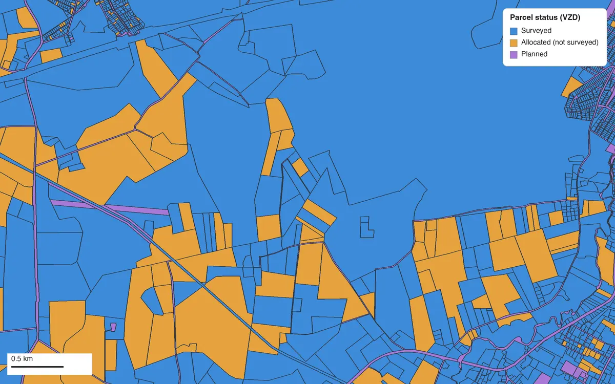
Surveyed (uzmērīta) parcels have been measured on the ground. Allocated (ierādīta) ones have had their boundaries marked out but not surveyed, and planned (projektēta) ones exist on a plan: around Jelgava, mostly roads. Parcel maps are not surveys, and the area is the area on the map.
The municipalities, as the VZD's files held them on 7 November 2026:
| Municipality | Parcels | Download |
|---|---|---|
| Rīga | 53,206 | 21.8 MB |
| Daugavpils | 21,048 | 8.3 MB |
| Jelgava | 14,284 | 4.5 MB |
| Jūrmala | 13,095 | 5.4 MB |
| Liepāja | 8,333 | 3.2 MB |
| Rēzekne | 6,544 | 2.6 MB |
| Ventspils | 8,310 | 3.5 MB |
| Aizkraukles novads | 26,409 | 15.7 MB |
| Alūksnes novads | 18,844 | 10.6 MB |
| Augšdaugavas novads | 51,594 | 23.3 MB |
| Ādažu novads | 15,049 | 5.8 MB |
| Balvu novads | 29,578 | 13.1 MB |
| Bauskas novads | 36,233 | 17.9 MB |
| Cēsu novads | 31,966 | 19.4 MB |
| Dienvidkurzemes novads | 41,726 | 23.0 MB |
| Dobeles novads | 21,919 | 11.9 MB |
| Gulbenes novads | 20,014 | 12.4 MB |
| Jelgavas novads | 27,051 | 11.2 MB |
| Jēkabpils novads | 37,420 | 18.8 MB |
| Krāslavas novads | 41,344 | 22.1 MB |
| Kuldīgas novads | 26,669 | 14.6 MB |
| Ķekavas novads | 20,452 | 8.4 MB |
| Limbažu novads | 34,317 | 14.3 MB |
| Līvānu novads | 9,992 | 4.6 MB |
| Ludzas novads | 36,703 | 17.4 MB |
| Madonas novads | 35,097 | 20.1 MB |
| Mārupes novads | 17,235 | 6.9 MB |
| Ogres novads | 36,191 | 17.1 MB |
| Olaines novads | 15,069 | 5.2 MB |
| Preiļu novads | 22,971 | 12.2 MB |
| Rēzeknes novads | 52,525 | 25.6 MB |
| Ropažu novads | 20,048 | 8.7 MB |
| Salaspils novads | 9,067 | 3.4 MB |
| Saldus novads | 21,663 | 12.6 MB |
| Saulkrastu novads | 12,969 | 4.5 MB |
| Siguldas novads | 19,666 | 9.1 MB |
| Smiltenes novads | 19,581 | 11.8 MB |
| Talsu novads | 31,038 | 17.3 MB |
| Tukuma novads | 32,938 | 16.2 MB |
| Valkas novads | 8,288 | 5.8 MB |
| Valmieras novads | 35,445 | 20.2 MB |
| Ventspils novads | 17,970 | 10.4 MB |
Every municipality has its own page, in Latvian, with a map of its parcels by status and its numbers: all 42 municipalities. The names in the table link straight to them.
Put the Layers to Work
- Find a parcel's designation in the field. Stand on the land with your GPS position on the map and tap: the cadastral designation is there, with or without a signal once the layer is downloaded.
- See what's grown around you. The declared crops show the 2026 season field by field, and the field blocks the land that qualifies for payments.
- Combine them with your own data. Use Intersect to cut the declared fields by parcel, or lay your own sample points over them.
- Export or print. Share any layer as a Shapefile, GeoPackage, KML, GeoJSON or CSV, or print a PDF map. Each source's credit goes on the print and with the export.
Elsewhere in the Baltics? Reference Data also has Estonia's cadastre, field blocks and crop fields, Lithuania's reference parcels and soils, and Europe-wide nationally designated protected areas, 6,380 of them in Latvia. See Reference Data by country for the rest.
Questions
Do the layers show owners or farmers?
No. The VZD's open data names no owner, and LAD's layers carry crops, areas and numbers, never a person.
Why do the parcels come a whole municipality at a time?
That's how the VZD publishes its open cadastral data: one file per municipality, refreshed every week. The smallest, Rēzekne, is 2.6 MB; the largest, Rēzeknes novads, 25.6 MB.
How current are the parcels?
The VZD updates its files every week, and GoGIS downloads the current file each time.
Are the parcel boundaries surveys?
No. They're the cadastral map, and the area is measured on the map. Check the status: a planned or allocated parcel hasn't been surveyed. For a boundary on the ground, a surveyor has the last word.
Why are some crops in Latvian when the app is in English?
They aren't missing: GoGIS has English for every crop code in the 2026 declarations, and keeps LAD's own Latvian name in Crop (Latvian). A code added later shows its Latvian name until GoGIS learns it.
Do I need desktop GIS software, an account or an API key?
No. GoGIS downloads from LAD's open services and the VZD's open data files. There's no key, no account and nothing to unzip.
Latvia's fields and parcels, in your pocket
LAD's field blocks and crops and the VZD's cadastre, ready to download on your iPhone or iPad.
Get GoGIS on the App Store Get GoGIS on Google Play