Switzerland's Land Parcels & Farmland Use on Your iPhone & iPad
In Switzerland the land survey belongs to the cantons. Each canton keeps the parcels of the official cadastral survey (amtliche Vermessung, mensuration officielle, misurazione ufficiale) and the farmland use areas its farms declare each year, and shows them in its own GIS. The cantons also publish both through one shared service, geodienste.ch, run by their conference for geoinformation and cadastre (KGK), and most of them publish both as open data, free to reuse with credit.
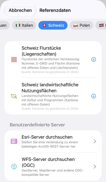
GoGIS has a Switzerland section in Reference Data with two datasets, Switzerland Land Parcels and Switzerland Farmland Use. Move the map to your area, pick one, and it downloads as a layer on your iPhone or iPad that you can read, search, combine with your own data and take into the field without a signal. GoGIS downloads only the cantons that publish the data as open data: 18 cantons and Liechtenstein for parcels, 18 cantons for farmland use. The list is below.
What you can do with it in GoGIS
Download the data oncePick the layers you need from Reference Data. They stay on your phone and work with no signal.

Tap the map, even with no signalRead everything the publisher records about the parcel, field or area under your finger.

Photos, sketches and notesTake a picture where you stand, sketch on the map, and write down what you saw.

Your photos on the mapSee every photo where you took it, and share a PDF report of the place and your notes.
The Two Swiss Datasets
- Switzerland Land Parcels — the parcels of the official survey (Liegenschaften, biens-fonds, fondi): each parcel's number, its E-GRID, the municipality's BFS number, its area in square metres and its canton. Liechtenstein's parcels come too, without an E-GRID, since the Principality publishes none. The layer arrives labeled by parcel number. Quelle: Kantone via geodienste.ch (KGK)
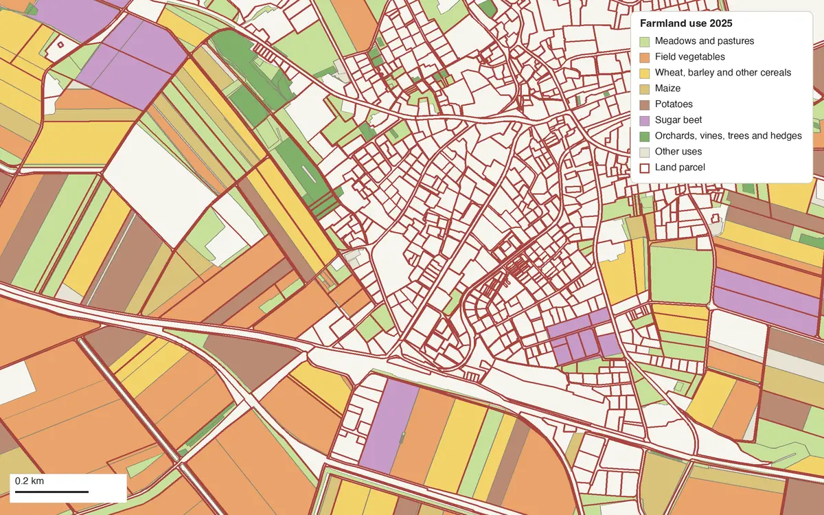
- Switzerland Farmland Use — the farmland use areas (landwirtschaftliche Nutzungsflächen) the cantons publish from what farms declare: each area's use (Zuckerrüben, Kartoffeln, Extensiv genutzte Wiesen (ohne Weiden)), its use code, its area in hectares, its canton, its reference year and the direct-payment programmes declared on it. No farm and no farmer. The layer arrives colored and labeled by use. Quelle: Kantone via geodienste.ch (KGK)
That short credit is the one in the dataset list. Each layer keeps the full credit, with the wording the cantons ask for, and GoGIS fills in the day of download for Geneva and the year for Lucerne:
Quelle: Kantone und Fürstentum Liechtenstein via geodienste.ch (KGK), amtliche Vermessung. Freie Nutzung, Quellenangabe Pflicht (opendata.swiss). Daten des Kantons Aargau · Geodaten Kanton Basel-Stadt · Données SITG, extraction du [download date] · Fonte: Amministrazione cantonale – Canton Ticino · Quelle: Lisag AG · Quelle: GIS Kanton Zug · übrige: jeweiliger Kanton bzw. Liechtenstein.
Quelle: Kantone via geodienste.ch (KGK), landwirtschaftliche Nutzungsflächen. Freie Nutzung, Quellenangabe Pflicht (opendata.swiss). Daten des Kantons Aargau · Données SITG, extraction du [download date] · © Géodonnées de la République et Canton du Jura · © [download year], rawi Kanton Luzern · Quelle: Lisag AG · Quelle: GIS Kanton Zug · übrige: jeweiliger Kanton.
Which Cantons Are Included
geodienste.ch carries every canton, but not every canton allows its data to be reused freely. St. Gallen and Graubünden publish under their own terms, not as open data. Jura, Lucerne, Neuchâtel, Nidwalden, Obwalden and Vaud ask for their approval before their parcels are reused, and Neuchâtel and Ticino require an account for farmland use. Basel-Stadt publishes no farmland use areas. GoGIS leaves all of those out, so what it downloads is yours to use.
| Canton | Land parcels | Farmland use |
|---|---|---|
| Aargau (AG) | Yes | Yes |
| Appenzell Ausserrhoden (AR) | Yes | Yes |
| Appenzell Innerrhoden (AI) | Yes | Yes |
| Basel-Landschaft (BL) | Yes | Yes |
| Basel-Stadt (BS) | Yes | No |
| Bern (BE) | Yes | Yes |
| Fribourg (FR) | Yes | Yes |
| Geneva (GE) | Yes | Yes |
| Glarus (GL) | Yes | Yes |
| Graubünden (GR) | No | No |
| Jura (JU) | No | Yes |
| Lucerne (LU) | No | Yes |
| Neuchâtel (NE) | No | No |
| Nidwalden (NW) | No | No |
| Obwalden (OW) | No | No |
| Schaffhausen (SH) | Yes | Yes |
| Schwyz (SZ) | Yes | Yes |
| Solothurn (SO) | Yes | Yes |
| St. Gallen (SG) | No | No |
| Thurgau (TG) | Yes | Yes |
| Ticino (TI) | Yes | No |
| Uri (UR) | Yes | Yes |
| Valais (VS) | Yes | Yes |
| Vaud (VD) | No | No |
| Zug (ZG) | Yes | Yes |
| Zürich (ZH) | Yes | Yes |
| Principality of Liechtenstein (FL) | Yes | No |
A page for every canton. Each canton with open data has its own page, in the canton's language, with a map of the data and its numbers: German-speaking cantons, French-speaking cantons and Ticino.
Farmland use areas are published by the canton the farm is registered in, not the canton the field lies in. Near a border, or where a farm works land in another canton, you may see areas farmed from an included canton inside one that isn't: in Ticino, a Thurgau farm's area comes, a Graubünden farm's doesn't.
When nothing in the area is open data, GoGIS says so rather than showing an empty layer: “The cantons in this area do not publish this data as open data (St. Gallen and Graubünden, for example). GoGIS downloads only the cantons that do.”
German, French, Italian or English
The column names follow the app's language when you download:
| App language | Land parcels | Farmland use |
|---|---|---|
| German | Nummer, E-GRID, BFS-Nr., Fläche (m²), Kanton | Nutzung, Code, Fläche (ha), Kanton, Jahr, Programme |
| French | Numéro, E-GRID, N° OFS, Surface (m²), Canton | Utilisation, Code, Surface (ha), Canton, Année, Programmes |
| Italian | Numero, E-GRID, N. UST, Superficie (m²), Cantone | Utilizzazione, Codice, Superficie (ha), Cantone, Anno, Programmi |
| English and every other language | Number, E-GRID, Municipality No. (BFS), Area (m²), Canton | Use, Code, Area (ha), Canton, Year, Programmes |
The uses themselves come from the cantons' own German, French and Italian versions of the data, so with the app in French a sugar beet field is Betteraves sucrières, in Italian Barbabietole da zucchero, in German Zuckerrüben. In English and every other language the uses are in German. A layer keeps the columns it was downloaded with.
How to Download the Layers
- Move the map to your area. Search for a village or an address, or pan and zoom to the land you want. GoGIS downloads what's on the screen. A village or a few farms is the right size.
- Open Reference Data. Tap Import, then Reference Data. The row of countries along the top opens on the one the map is showing, so with the map in Switzerland or Liechtenstein, the Switzerland datasets are the ones listed.
- Choose a dataset. GoGIS counts the area first; one download takes up to 50,000 parcels or use areas, and if the area holds more, GoGIS asks you to zoom in. geodienste.ch asks apps to send no more than ten requests a minute, so GoGIS waits at least six seconds between them: a farm-sized area arrives in about ten seconds, and 5 by 5 km of central Zürich, 17,954 parcels, in about half a minute.
- Read the map. Tap a parcel for its number and E-GRID, or a use area for its crop, year and programmes.
Next step: open the farmland layer's attribute table to filter the use areas by Use or Canton, total their Area (ha) with a column summary, or search the parcels for an E-GRID, and export the list to Excel as a CSV. See the attribute table on iPhone and iPad.
Put the Layers to Work
- Find a parcel in the field, offline. Walk to it with your GPS position on the map and the parcels on the screen. Once downloaded, the layer works with no signal.
- See what's grown around you. Around Ins in 2025, the use areas show the Seeland's field vegetables, potatoes, sugar beet and maize beside extensive meadows and high-stem orchard trees.
- Combine them with your own data. Use Intersect to see which parcels a use area crosses, or lay your own sample points or boundaries over both.
- Export or print. Share either layer as a Shapefile, GeoPackage, KML, GeoJSON or CSV, or print a PDF map. The credit goes on the print and with the export.
Protected areas too. Natura 2000 doesn't cover Switzerland, but the Europe section's Nationally Designated Areas (NatDA) holds 10,635 Swiss sites, such as the dry grassland inventory and forest reserves, and 44 in Liechtenstein. Next door, Reference Data also has Austria's fields and soils, Germany's cadastre and crop fields and France's cadastre and crop parcels. See Reference Data by country for the rest.
Questions
Why isn't my canton there?
Because it doesn't publish the data as open data. St. Gallen and Graubünden have terms of their own, and Jura, Lucerne, Neuchâtel, Nidwalden, Obwalden and Vaud want to approve each reuse of their parcels (Jura and Lucerne do publish farmland use, so that comes). GoGIS adds a canton when its terms allow it.
Do the parcels show who owns them?
No. GoGIS asks the service for the parcel's number, E-GRID, BFS number, area and canton, nothing else. Ownership is a matter for the land register.
Are these the legal boundaries?
They're the parcels of the official survey, on which the land register rests. Your phone's GPS, though, is good to a few metres, so for a boundary on the ground a surveyor has the last word.
What is the E-GRID?
The federal parcel identifier: CH followed by twelve digits, one number for each parcel across Switzerland, used by the land register and the cadastre of public-law restrictions. Liechtenstein's parcels have none.
Which year is the farmland use?
Each area carries its reference year in the Year column. The areas downloaded around Ins on 11 November 2026 were all from 2025.
Do the use areas show the farm?
No. GoGIS doesn't ask for the farm unit's identifier, and the service names no farmer.
Do I need desktop GIS software, an account or an API key?
No. GoGIS downloads from geodienste.ch's open service. There's no key, no account and nothing to unzip.
Switzerland's parcels and fields, in your pocket
The cantons' open land survey and farmland use, ready to download on your iPhone or iPad.
Get GoGIS on the App Store Get GoGIS on Google Play