French Cadastre & Crop Parcels on Your iPhone & iPad
France publishes two of the most useful farm maps in Europe for free. The cadastre has every parcel of land in the country, with its section and number. The Registre parcellaire graphique (RPG) has every field declared for Common Agricultural Policy aid, with the crop grown on it. IGN serves both on its Géoplateforme, under an open licence.
Getting them into the field is another matter. The services are built for desktop GIS, and the RPG's attribute table is a row of codes: BTH, MIS, PPH, CZH, a group number, a precision code that means something different for every crop. GoGIS now has a France section in Reference Data. Move the map to your area, pick a dataset, and the parcels download as a layer on your iPhone or iPad, with every code written out.
The Two French Datasets
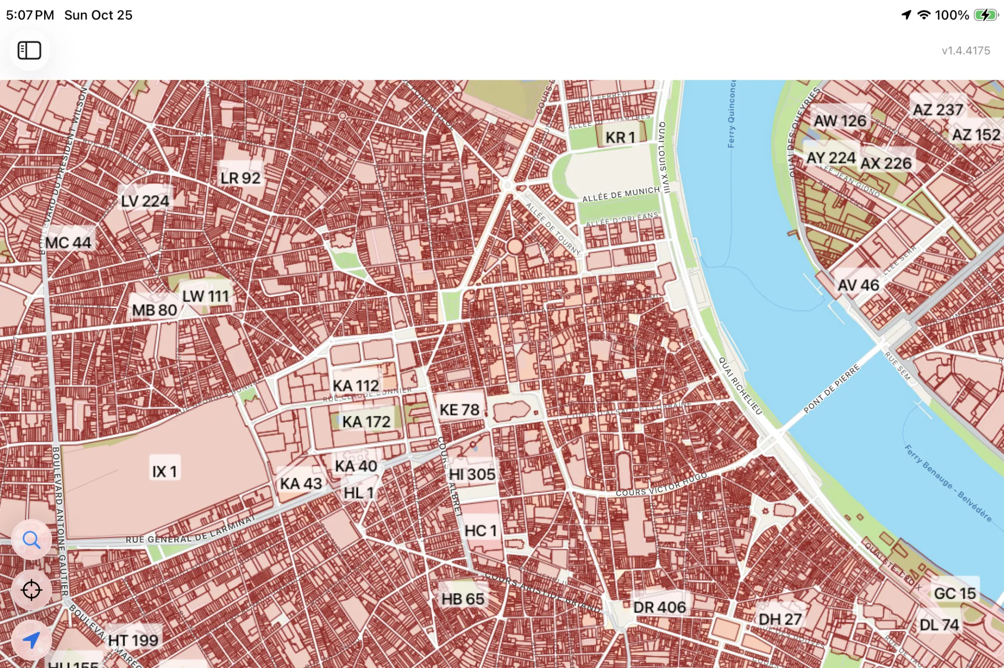
- France Cadastral Parcels — the cadastral plan (plan cadastral), from IGN's Parcellaire Express. Each parcel is labeled the way French plans write it, section and number (ZA 12), with its commune, its area on the cadastre in hectares, its national identifier and the commune's INSEE code. Parcels are small, so zoom in to a village or a few farms before you download. IGN – Parcellaire Express (PCI), from the DGFiP cadastre. Licence Ouverte / Etalab 2.0.
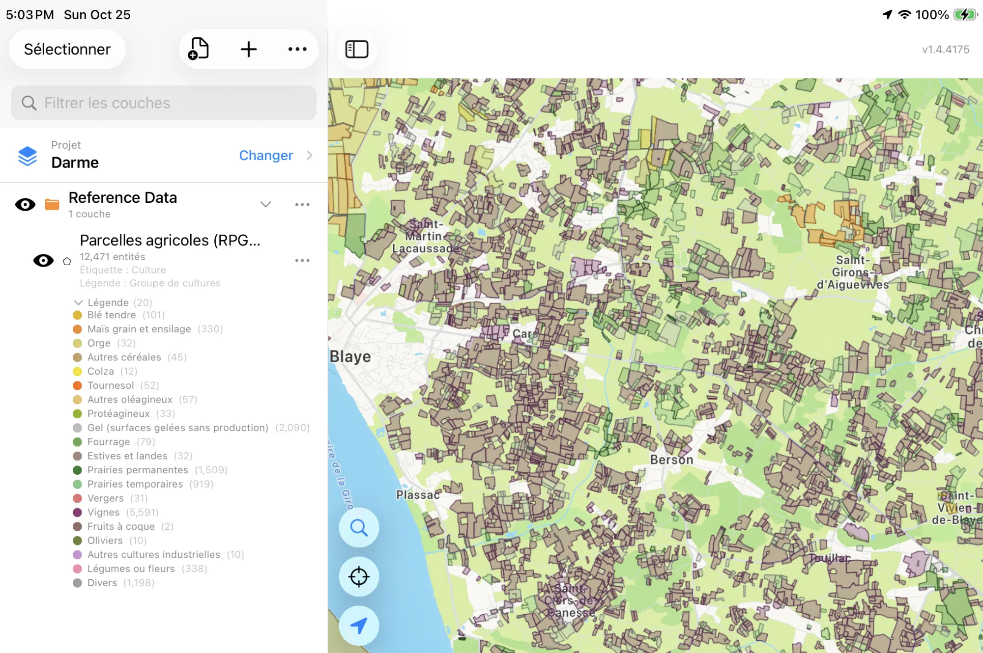
- France Crop Parcels (RPG 2025) — the agricultural parcels (parcelles agricoles) farmers declared on TelePAC for CAP (PAC) aid in the 2025 campaign. Each one has its main crop, crop group, the crop's detail (such as grain harvest or silage), the land category, any catch crops sown after it, its area, whether it is farmed organically, and its block (îlot). The layer arrives colored by crop group. You can download a wider area than the cadastre, up to a canton or so. IGN / ASP – Registre parcellaire graphique (RPG) 2025. Licence Ouverte / Etalab 2.0.
In English or in French
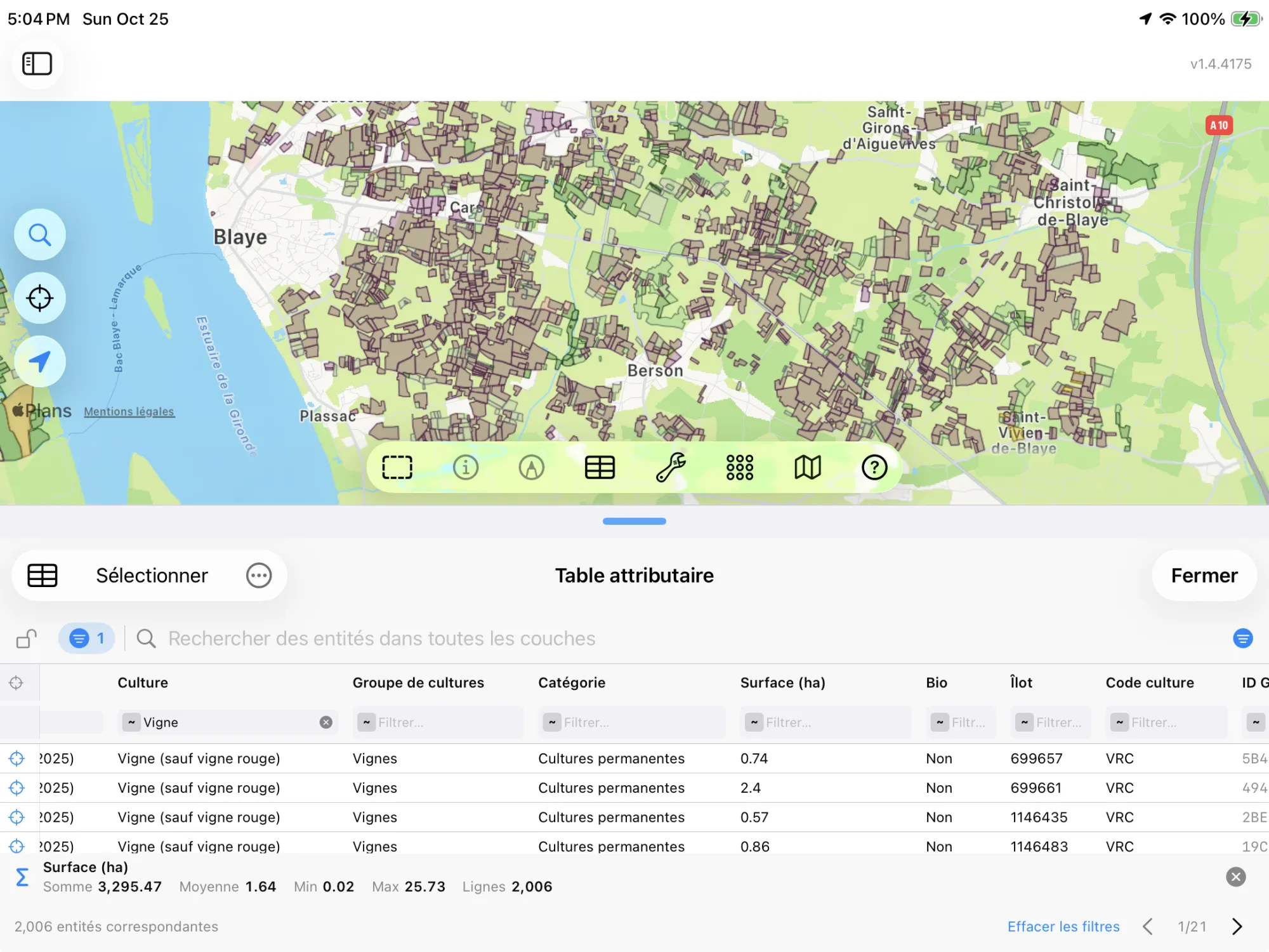
This is French data, so GoGIS speaks French when you do. With the app set to French, the columns are Culture, Groupe de cultures, Surface (ha), Bio, and the crops are named as the RPG nomenclature names them: Blé tendre d'hiver, Colza d'hiver, Maïs (hors maïs doux). In any other language you get English throughout: Crop, Crop Group, Area (ha), Organic, and Winter common wheat, Winter rapeseed, Corn (excluding sweet corn).
Both the column names and the values change, and so does the legend, so a printed map or an exported shapefile reads in one language from end to end. The original crop code stays in its own column, so you can always match a parcel back to the official list.
The Crop Groups
The RPG sorts its 144 crops into 24 groups, and the layer's legend uses them, colored roughly as the crops look from the air. Tap a parcel for its exact crop, or change the legend to color by crop, organic status or any other column.
| Crop group | In French |
|---|---|
| Common wheat | Blé tendre |
| Grain and silage corn | Maïs grain et ensilage |
| Barley | Orge |
| Other cereals | Autres céréales |
| Rapeseed | Colza |
| Sunflower | Tournesol |
| Other oilseeds | Autres oléagineux |
| Protein crops | Protéagineux |
| Fiber crops | Plantes à fibres |
| Set-aside (no production) | Gel (surfaces gelées sans production) |
| Rice | Riz |
| Grain legumes | Légumineuses à grains |
| Fodder | Fourrage |
| Summer mountain pasture and heath | Estives et landes |
| Permanent grassland | Prairies permanentes |
| Temporary grassland | Prairies temporaires |
| Orchards | Vergers |
| Vineyards | Vignes |
| Nuts | Fruits à coque |
| Olive groves | Oliviers |
| Other industrial crops | Autres cultures industrielles |
| Vegetables or flowers | Légumes ou fleurs |
| Sugar cane | Canne à sucre |
| Miscellaneous | Divers |
How to Download the Parcels
- Move the map to your area. Search for a commune or an address, or pan and zoom to the fields you want. GoGIS downloads what's on the screen.
- Open Reference Data. Tap Import, then Reference Data. The row of countries along the top opens on the one the map is showing, so with the map in France, the France datasets are the ones listed.
- Choose a dataset. The download keeps going if you switch apps or the screen would otherwise lock, and progress shows on the map. If an area holds a great many parcels, GoGIS tells you how many and asks before it downloads them.
- Read the map. The crop parcels arrive colored by crop group and labeled by crop; the cadastre arrives labeled by parcel number. Tap any parcel to see everything about it.
Put the Parcels to Work
- Find a parcel on the ground. Walk to it with your GPS position on the map and the parcel numbers on screen, with or without signal once the layer is downloaded.
- See what's grown around you. The crop parcels show the whole landscape's rotation at a glance: where the wheat, rapeseed, corn and grassland are this year, and which neighbours farm organically.
- Combine them with your own data. Open your field boundaries or sample points over them, or use Intersect to cut the crop parcels by the cadastre and see which crops sit on which parcels.
- Export or print. Share either layer as a Shapefile, GeoPackage, KML, GeoJSON or CSV, or print a PDF map. The source credit the licence asks for goes on the print and with the export.
Elsewhere in the world? Reference Data also has Japan's farm field outlines, Canadian soil maps, US soils and flood maps, and OpenStreetMap roads, rivers, buildings and land use anywhere.
Questions
Does the cadastre show legal boundaries?
No. The French cadastre is a tax map. It's what everyone uses to find a parcel, but only a boundary survey (bornage) by a géomètre-expert fixes where a boundary legally lies.
Does the RPG cover every field?
It covers the parcels declared for CAP aid, which is most of France's farmland but not all of it. Land nobody declared, such as some vineyards, orchards and small holdings, isn't in it. The RPG is anonymous: it doesn't say who farms a parcel.
Why 2025?
The RPG is published one campaign at a time, and each year's crop list changes a little. GoGIS reads the 2025 campaign, the latest IGN has released, and its crop list is the one the layer decodes. When a newer campaign is published, an app update brings it in.
Is it the same cadastre as cadastre.gouv.fr?
Yes. cadastre.gouv.fr shows the DGFiP's plan online; IGN publishes the same parcels as data (Parcellaire Express), and that's what GoGIS downloads, as a layer you can take offline, query and export.
Do I need desktop GIS software or an account?
No. GoGIS downloads the parcels straight from the IGN Géoplateforme. There's no key, no account and nothing to unzip.
France's parcels, in your pocket
The cadastre and the 2025 crop parcels, in English or French, ready to download on your iPhone or iPad.
Get GoGIS on the App Store