Statewide Parcels for 19 US States and DC on Your iPhone & iPad
There is no national parcel map in the United States. Counties keep the tax maps, and the states that gather them into one statewide layer each do it their own way: their own server, their own column names (parno in North Carolina, PAMS_PIN in New Jersey, ACCTID in Maryland), lot sizes in acres in one state and square feet in the next, land use written as 02 - MOBILE HOME in one county and as a three-digit class in another.
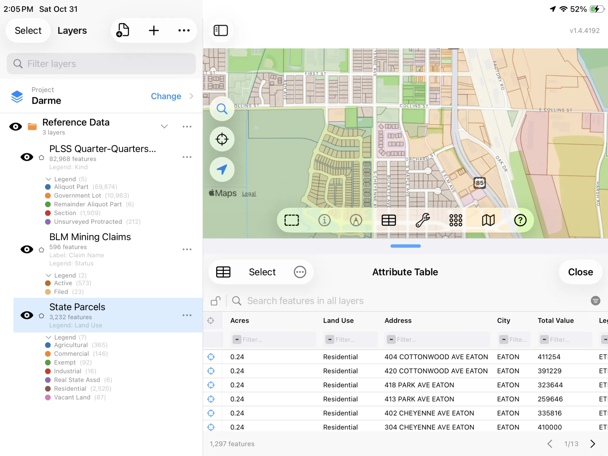
GoGIS now has State Parcels in the United States section of Reference Data. Move the map to your area and pick it: GoGIS asks every state the map touches, rewrites each answer into the same nine columns, and gives you one layer, merged across the state line if your area crosses one. Owners' names and mailing addresses are never asked for.
Six states go further, a county at a time. In Arkansas, Maryland, Montana, New Jersey, North Carolina and Wyoming, GoGIS downloads a whole county with every column the state publishes, owners included where the state publishes them, colored by land use: Arkansas Parcels by County and so on, at the top of the United States datasets when the map is there. State Parcels leaves those six to them. See county parcel maps and land use for every county. Wisconsin’s parcels, owners included, are in a separate app, WI 2026: see its parcel maps for all 72 Wisconsin counties.
If you're after the property lines around a place you work or land you're looking at, this is the layer. Once it's downloaded it stays on your device, so the parcels and your GPS position work offline, with no signal. Each state also has its own page below, with its own columns, coverage and a sample of its data.
What you can do with it in GoGIS
Download the data oncePick the layers you need from Reference Data. They stay on your phone and work with no signal.

Tap the map, even with no signalRead everything the publisher records about the parcel, field or area under your finger.

Photos, sketches and notesTake a picture where you stand, sketch on the map, and write down what you saw.

Your photos on the mapSee every photo where you took it, and share a PDF report of the place and your notes.
One Dataset, 19 States and DC, Six of Them by County
- State Parcels — the tax parcels each state publishes, in nine plain columns: Parcel ID, State, County, Acres, Land Use, Address, City, Total Value and Legal Description. Land use comes in words, without its code and in title case where the county wrote capitals (Mobile Home, Residential, Single Unit Dwelling, Farm (Qualified)). Acres are the ones the state reports where it reports them, and measured from the parcel's outline where it doesn't. The layer arrives colored by land use. UT: State of Utah, SGID / UGRC, CC BY 4.0; CO: State of Colorado public parcels; NC: NC OneMap, NC Center for Geographic Information and Analysis and NC county governments; MN: MnGeo, parcels compiled from opt-in open data counties; IN: Indiana GIS Data Harvest Program (IGIO); AR: Arkansas GIS Office, CC BY 4.0; VA: Virginia Geographic Information Network (VGIN), CC0; MA: MassGIS, Commonwealth of Massachusetts EOTSS; NJ: NJ Office of GIS (NJOGIS); MD: State of Maryland (MD iMAP, MDP, SDAT); CT: State of Connecticut GIS Office, CC0; MT: Montana State Library, Montana Cadastral (Department of Revenue); ND: North Dakota GIS Hub and ND county governments; WY: Wyoming Office of State Lands and Investments, county parcels; HI: Hawaii Statewide GIS Program; Counties of Hawaii, Honolulu, Kauai and Maui; DE: Delaware FirstMap and Delaware county governments; NH: NH GRANIT (University of New Hampshire) and NH municipalities; ID: Idaho contributing counties (Public Idaho Parcels); ME: Maine GeoLibrary; DC: District of Columbia (DC GIS, Office of Tax and Revenue), CC BY 4.0. Parcel maps are not surveys.
What Each State Publishes
Every state fills Parcel ID, State and Acres. The rest depends on what the state's own layer carries:
| State | Coverage | Beyond the parcel ID and acres |
|---|---|---|
| Utah | UGRC's statewide layer | County, address, city; acres measured from the outline |
| Colorado | The 44 of 64 counties that share their parcels publicly | County, land use, address, city, appraised value, legal description |
| North Carolina | All 100 counties (NC OneMap) | By county: every column the state publishes, colored by land use (county maps) |
| Minnesota | 59 of 87 counties, the ones that publish open data | County, use class, address, city, estimated market value, legal description; deed acres where given |
| Indiana | All 92 counties (IGIO Data Harvest) | County, property class (Agricultural (101)), address, city |
| Arkansas | 75 counties, some only in part | By county: every column the state publishes, colored by land use (county maps) |
| Virginia | VGIN's statewide layer | Locality only: outlines and IDs |
| Massachusetts | Every town but Boston (MassGIS Level 3) | Use, address, town, total value; lot size, converted from square feet where needed |
| New Jersey | All 21 counties (MOD-IV) | By county: every column the state publishes, colored by land use (county maps) |
| Maryland | Every county and Baltimore City | By county: every column the state publishes, colored by land use (county maps) |
| Connecticut | All 169 towns | State use description, address, town, assessed value |
| Montana | All 56 counties (Department of Revenue) | By county: every column the state publishes, colored by land use (county maps) |
| North Dakota | All 53 counties (ND GIS Hub) | County; a legal description built from plat, lot, section, township and range |
| Wyoming | All 23 counties, tax year 2025 | By county: every column the state publishes, colored by land use (county maps) |
| Hawaii | All four counties | County; Tax Map Keys as parcel IDs |
| Delaware | All three counties (FirstMap) | County only: outlines and IDs |
| New Hampshire | The towns that send theirs to GRANIT | County, address, town |
| Idaho | 13 of 44 counties | County; where the county sends them, address, city, total value, legal description |
| Maine | The towns that send theirs to the GeoLibrary | Outlines and IDs only |
| District of Columbia | The whole District (tax lots) | Property type, address, total value |
Total Value is the value the state publishes, so it means different things in different states: appraised in Colorado, estimated market value in Minnesota, net taxable value in New Jersey, assessed in Connecticut, actual value in Wyoming. Compare values within a state, not across states. Massachusetts and Connecticut are organized by town rather than county, so for them the town goes in City and County stays empty. DC has no county either.
How to Download the Parcels
- Move the map to your area. Search for a town or an address, or pan and zoom to the land you want. GoGIS downloads what's on the screen. Parcels are small, so zoom in to a town or a few square miles before you download.
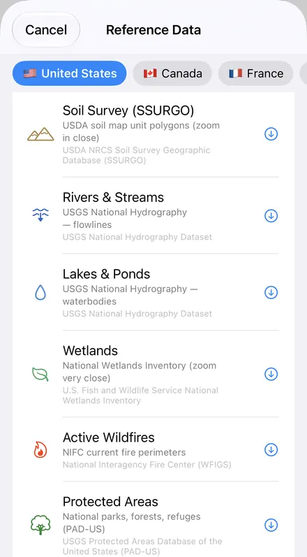
- Open Reference Data. Tap Import, then Reference Data. The row of countries along the top opens on the one the map is showing, so with the map in the US, the United States datasets are the ones listed.
- Choose State Parcels (or, in the six county states, Arkansas Parcels by County and the like, then a county). The download keeps going if you switch apps or the screen would otherwise lock, and progress shows on the map. Each state's server counts what's in the area first; if there are a great many parcels, GoGIS tells you how many and asks before it downloads them.
- Read the map. Parcels arrive colored by land use. Tap one to see its ID, acres, address and the rest.
Put the Parcels to Work
- Sort and total in the table. In the layer's attribute table, filter Land Use or County, sort by Acres or Total Value, sum the acres with a column summary, and export the parcels as a CSV that Excel opens. See the attribute table on iPhone and iPad.
- Find a parcel in the field. Walk to it with your GPS position on the map and the parcel outlines on the screen, with or without a signal once the layer is downloaded.
- Read the land around a site. Land use shows farms, homes and commercial land at a glance; tap a parcel for its ID and acres before you call the county.
- Combine them with your own data and other layers. Lay SSURGO soils or FEMA flood zones over the parcels, or use Intersect to see which parcels a flood zone or a buffer around a stream touches.
- Export or print. Share the layer as a Shapefile, GeoPackage, KML, GeoJSON or CSV, or print a PDF map. Each state's credit goes on the print and with the export.
More reference data? See Reference Data by country. In the US, it also has the BLM's PLSS grid, mining claims and grazing allotments, SSURGO soils, FEMA flood zones, rivers and wetlands, and OpenStreetMap roads, rivers, buildings and land use anywhere.
Questions
Do the parcels show the owners?
No. GoGIS never asks the state services for owners' names or mailing addresses, even in the states that publish them. You get the parcel, its ID, acres, use, site address and value; the owner of record is a question for the county.
What happens where my area crosses a state line?
You get both sides. GoGIS asks each state whose area the map touches and merges the answers into one layer, and the State column says whose data each parcel is.
Why isn't my state on the list?
GoGIS includes a state when it publishes one statewide parcel layer that is open to use and answers without a key or a token. Many states leave parcels to their counties, some services need a token or refuse queries, and some states' terms don't allow commercial reuse.
Are these survey boundaries?
No. They're tax maps, drawn for assessment, and every state says the same: parcel maps are not surveys. For a boundary on the ground, the deed and a licensed surveyor have the last word.
Can I see property lines offline?
Yes. Download the parcels while you have a signal, and they stay on your device, with your GPS position over them, wherever you go next. The lines are tax map lines, so treat them as a good guide rather than a survey.
Do I need desktop GIS software, an account or an API key?
No. GoGIS downloads from each state's open service. There's no key, no account and nothing to unzip.
Parcels for 19 states and DC, in your pocket
Statewide tax parcels in the same columns everywhere, ready to download on your iPhone or iPad.
Get GoGIS on the App Store Get GoGIS on Google Play