Spain's SIGPAC Crops & Parcels on Your iPhone & iPad
Every CAP payment in Spain is made against SIGPAC, the Sistema de Información Geográfica de Parcelas Agrícolas. It divides farmland into recintos, the smallest pieces of a cadastral parcel with a single use, each with a reference like 34:31:0:0:2:17:2: province, municipality, aggregate, zone, polygon, parcel and recinto. The Fondo Español de Garantía Agraria (FEGA) publishes the recintos and the crops farmers declare on them as open data, under CC BY 4.0, with every crop as one of 933 product codes.
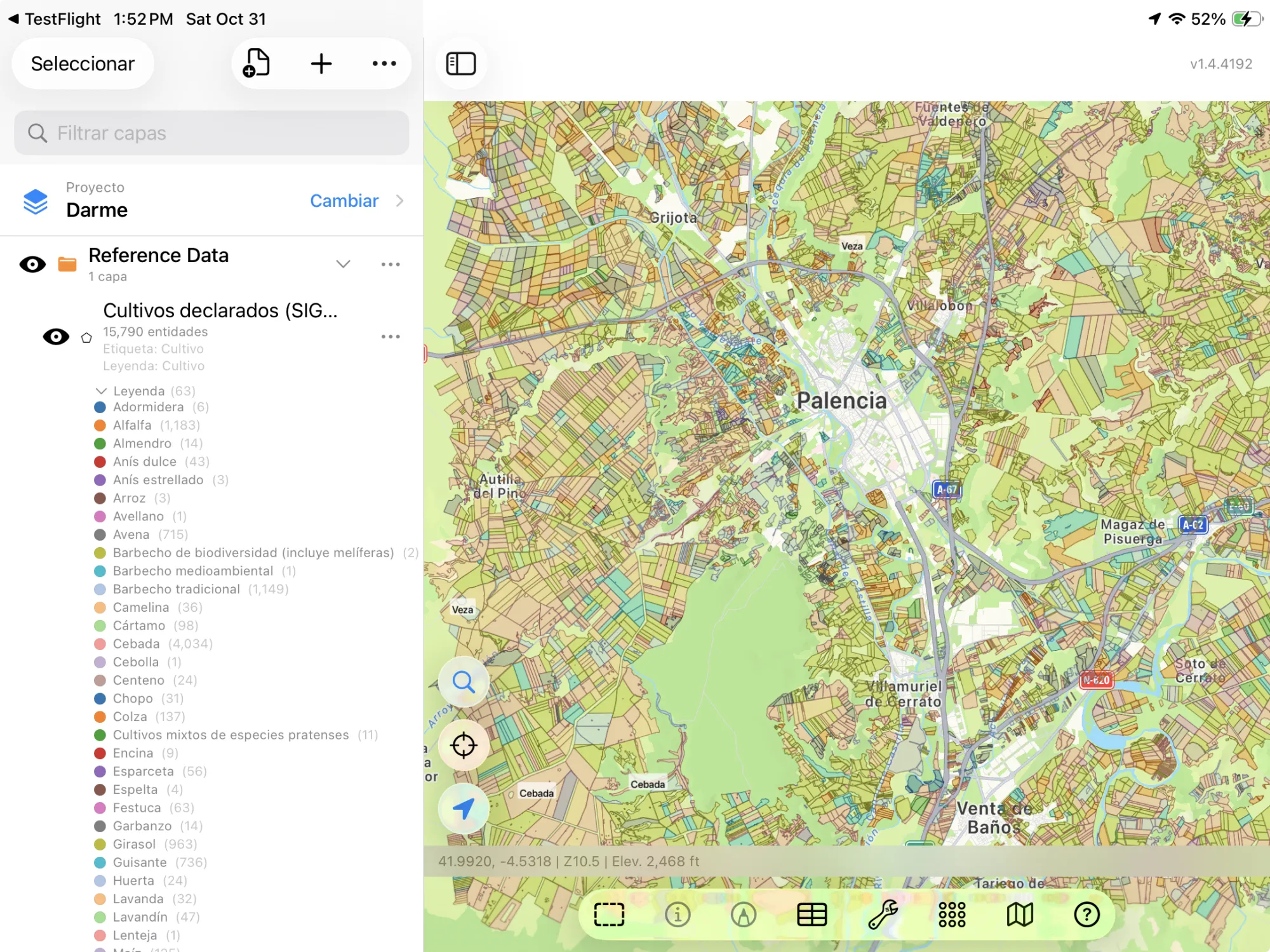
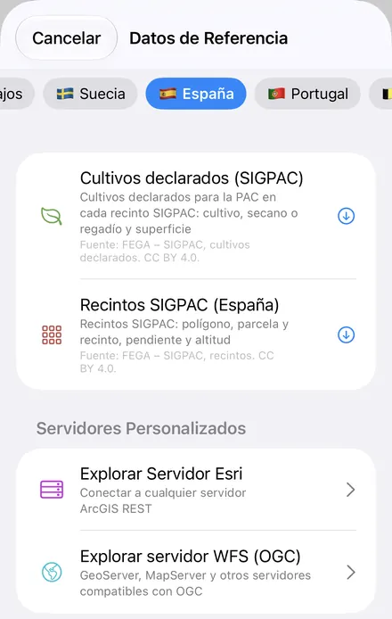
If you know recintos from the Visor SIGPAC, these are the parcels you look up there, as a layer on your own device that works offline. GoGIS now has a Spain section in Reference Data. Move the map to your area, pick a dataset, and it downloads as a layer on your iPhone or iPad, with the product codes turned into crop names and areas in hectares: in Spanish when the app is in Spanish, in English otherwise.
What you can do with it in GoGIS
Download the data oncePick the layers you need from Reference Data. They stay on your phone and work with no signal.

Tap the map, even with no signalRead everything the publisher records about the parcel, field or area under your finger.

Photos, sketches and notesTake a picture where you stand, sketch on the map, and write down what you saw.

Your photos on the mapSee every photo where you took it, and share a PDF report of the place and your notes.
The Two Spanish Datasets
- Spain Declared Crops (SIGPAC) — one feature for each crop declared for the CAP on a recinto: the crop (Soft wheat, Barley, Olive, Vineyard), any second crop, the system (Rain-fed or Irrigated), the declared area in hectares, the full SIGPAC reference, and the province, municipality, polygon, parcel and recinto in columns of their own. The CAP application number, which identifies the farmer, is left out. The layer arrives colored and labeled by crop. Fuente: FEGA – SIGPAC, cultivos declarados. CC BY 4.0.
- Spain SIGPAC Parcels — the recintos themselves: the SIGPAC reference, province, municipality, polygon, parcel and recinto, with each recinto's mean slope in percent and its altitude in metres. The layer arrives labeled by parcel number. Fuente: FEGA – SIGPAC, recintos. CC BY 4.0.
Where Does It Work? Every Province
FEGA's SIGPAC is national, so GoGIS downloads recintos and declared crops in all 50 provinces: the whole mainland, the Balearics and the Canaries, Navarra and the Basque Country included. It works the same in Palencia, Valladolid, León, Burgos or Zamora as in Lleida, Huesca, Jaén or Badajoz. The recintos are the current campaign's, and the declared crops are from the latest campaign FEGA publishes.
- Andalucía: Almería, Cádiz, Córdoba, Granada, Huelva, Jaén, Málaga, Sevilla
- Aragón: Huesca, Teruel, Zaragoza
- Canarias: Las Palmas, Santa Cruz de Tenerife
- Castilla-La Mancha: Albacete, Ciudad Real, Cuenca, Guadalajara, Toledo
- Castilla y León: Ávila, Burgos, León, Palencia, Salamanca, Segovia, Soria, Valladolid, Zamora
- Cataluña: Barcelona, Girona, Lleida, Tarragona
- Comunitat Valenciana: Alicante, Castellón, Valencia
- Extremadura: Badajoz, Cáceres
- Galicia: A Coruña, Lugo, Ourense, Pontevedra
- País Vasco: Álava (Araba), Bizkaia (Vizcaya), Gipuzkoa (Guipúzcoa)
- Single-province communities: Asturias, Cantabria, Illes Balears, La Rioja, Madrid, Murcia, Navarra
Ceuta and Melilla aren't in FEGA's data, so there are no layers to download there.
In Spanish or English
With GoGIS in Spanish, the columns are Cultivo, Cultivo secundario, Sistema (Secano or Regadío), Superficie (ha), Referencia SIGPAC, Provincia, Municipio, Polígono, Parcela and Recinto, and every crop has its name from FEGA's product list. In any other language they're Crop, Second Crop, Irrigation, Area (ha), SIGPAC Reference and so on, with the crops in English: the field crops, fruit, vegetables, herbs and trees have English names, and the rarer codes and mixtures keep FEGA's Spanish name. The recintos add Pendiente media (%) and Altitud (m), or Mean Slope (%) and Altitude (m). Columns, values and legend change together, so a printed map or an exported Shapefile stays in one language.
How to Download the Layers
- Move the map to your area. Search for a town or an address, or pan and zoom to the land you want. GoGIS downloads what's on the screen.
- Open Reference Data. Tap Import, then Reference Data. The row of countries along the top opens on the one the map is showing, so with the map in Spain, the Spain datasets are the ones listed.
- Choose a dataset. The download keeps going if you switch apps or the screen would otherwise lock, and progress shows on the map. FEGA's server counts what's in the area first; if there are a great many recintos, GoGIS tells you how many and asks before it downloads them.
- Read the map. Declared crops arrive colored and labeled by crop, recintos labeled by parcel. Tap one to see its SIGPAC reference and everything else.
Put the Layers to Work
- Total the irrigated olives. In the declared crops' attribute table, filter Irrigation to Irrigated and Crop to Olive, then sum the declared hectares with a column summary; filter the recintos by mean slope and export them as a CSV for Excel. See the attribute table on iPhone and iPad.
- See what's grown around you. The declared crops show a whole landscape's cropping at a glance: cereals, olives, vines, almonds, and which fields are irrigated.
- Find a recinto's SIGPAC reference in the field. Stand in it with your GPS position on the map and tap: the full reference is there, with or without a signal once the layer is downloaded.
- Read slope and altitude. The recintos carry FEGA's mean slope and altitude, ready to style the map by slope or filter steep ground.
- Combine them with your own data. Lay your own field boundaries or sample points over the recintos, or use Intersect to cut your fields by recinto.
- Export or print. Share either layer as a Shapefile, GeoPackage, KML, GeoJSON or CSV, or print a PDF map. FEGA's credit goes on the print and with the export.
Elsewhere in Europe? Reference Data also has Portugal's cadastre, with five more countries' cadastral parcels, the French cadastre and crop parcels, Austria's INVEKOS fields and soil map, and OpenStreetMap roads, rivers, buildings and land use anywhere.
Questions
Does it work as a SIGPAC viewer offline?
Yes, once the layers are downloaded. You need a connection to download them; after that they stay on your iPhone or iPad, and the recintos, the declared crops, each one's SIGPAC reference and your GPS position all work with no signal, out in the field. The satellite imagery underneath loads from the internet and can be missing offline. To take the layers into another program, export them as a KML file, Shapefile or GeoPackage.
Does GoGIS include the Catastro's cadastral parcels for Spain?
No. The Catastro's licence statements disagree, and one of them forbids redistribution, so GoGIS leaves it out. SIGPAC is built on the cadastre, though: its polygons and parcels carry the cadastral numbering, and the recintos divide each parcel by use.
Does the recinto layer show the SIGPAC land use?
No. FEGA's open API publishes each recinto's reference, slope and altitude, but not its land use. For what is actually grown, download the declared crops.
Do the layers show who declared a crop?
No. The CAP application number identifies the farmer, so GoGIS drops it. The layers carry the crop, the area and the SIGPAC reference, nothing about the applicant.
Why are the province and municipality numbers?
They're the codes SIGPAC uses in its references, kept as FEGA publishes them so that the columns match the SIGPAC reference digit for digit.
Do I need desktop GIS software, an account or an API key?
No. GoGIS downloads from FEGA's open service. There's no key, no account and nothing to unzip.
Spain's SIGPAC, in your pocket
FEGA's declared crops and recintos, in Spanish or English, ready to download on your iPhone or iPad.
Get GoGIS on the App Store Get GoGIS on Google Play