Belgium's Crop Parcels, Cadastre & Soil Map on Your iPhone & iPad
In Belgium, land data belongs to the regions, and each publishes its own. Flanders publishes the farm parcels declared each year with their main crop (Departement Landbouw en Visserij), the administrative parcel plan of the cadastre (Digitaal Vlaanderen's Adpf), and the Belgian soil map for Flanders (DOV), all under the Flemish free-reuse licence. Wallonia publishes its anonymous farm parcels from SIGEC, under CC BY 4.0.
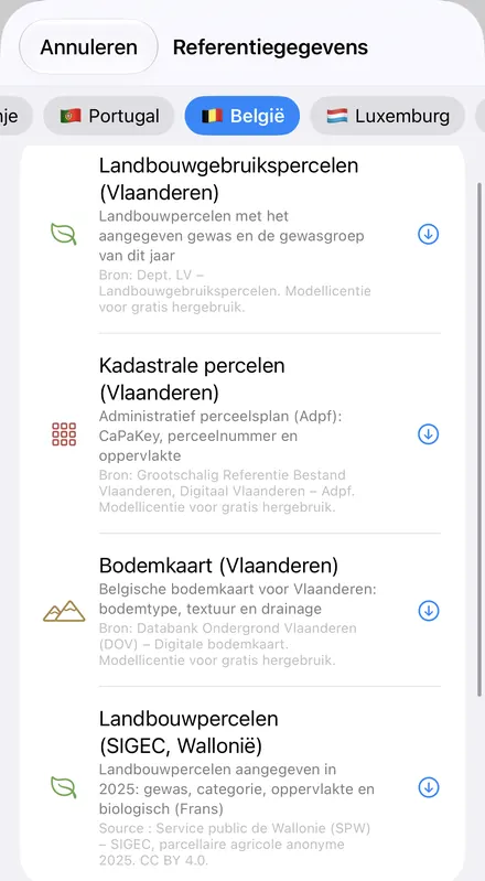
GoGIS now has a Belgium section in Reference Data with all four. Move the map to your area, pick a dataset, and it downloads as a layer on your iPhone or iPad, with areas in hectares: Flemish data in Dutch when the app is in Dutch, Walloon data in French when it's in French, English column names otherwise.
What you can do with it in GoGIS
Download the data oncePick the layers you need from Reference Data. They stay on your phone and work with no signal.

Tap the map, even with no signalRead everything the publisher records about the parcel, field or area under your finger.

Photos, sketches and notesTake a picture where you stand, sketch on the map, and write down what you saw.

Your photos on the mapSee every photo where you took it, and share a PDF report of the place and your notes.
The Four Belgian Datasets
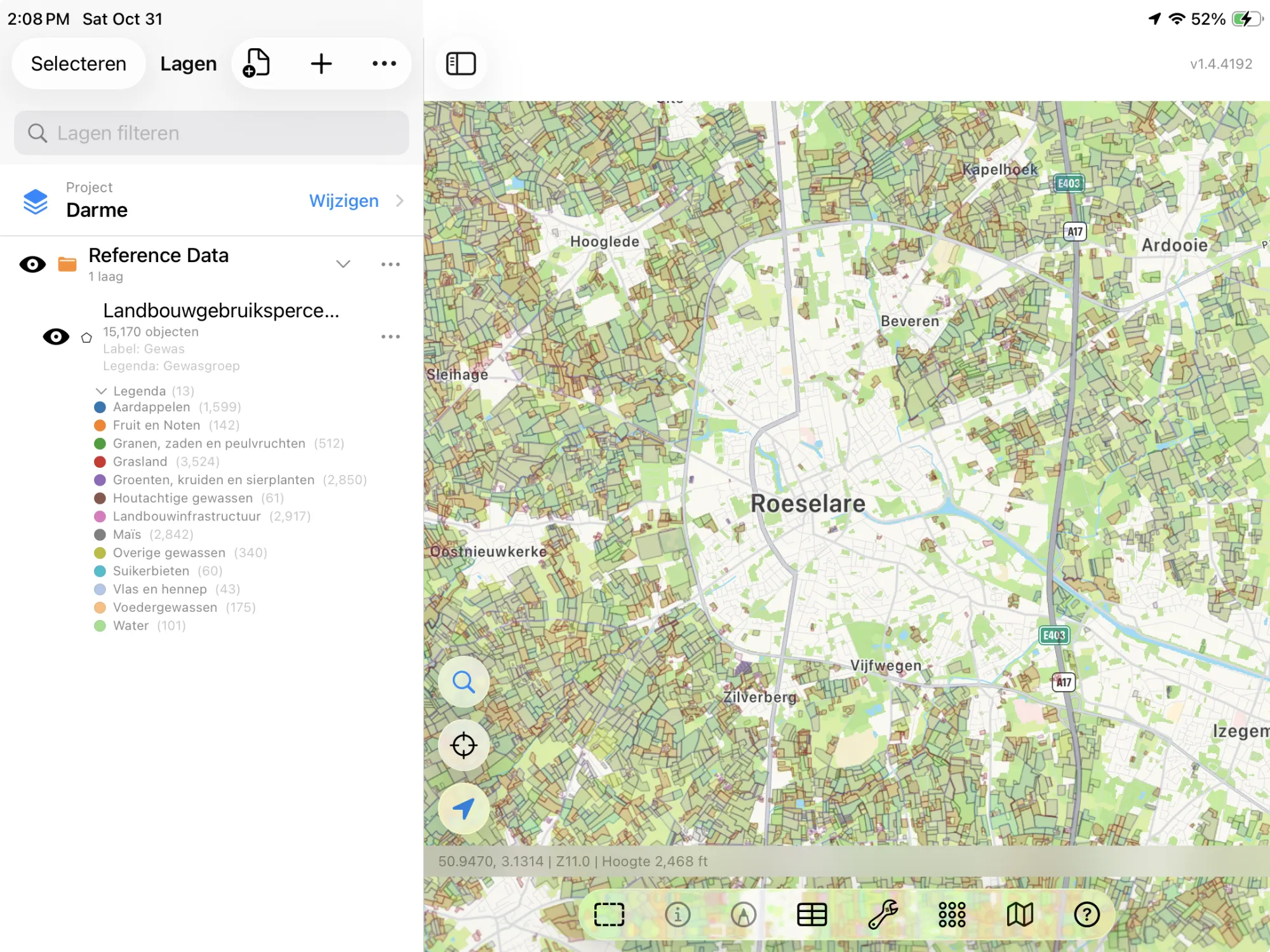
- Flanders Crop Parcels — this year's farm parcels with their declared main crop: the crop as the department names it (Silomaïs, Korrelmaïs, Meerjarige fruitteelten (peer)), its crop group, the crop code, how it's managed where that's recorded (Maaien met afvoer, greenhouse growing) and the area in hectares, measured from the parcel's outline. No farmers' names. The layer arrives colored by crop group and labeled by crop. Bron: Dept. LV – Landbouwgebruikspercelen. Modellicentie voor gratis hergebruik.
- Flanders Cadastral Parcels — the administrative parcel plan (Adpf) as at 1 January: each parcel's CaPaKey (division, section and number), its parcel number, its municipality's NIS code and its area in hectares. The layer arrives labeled by parcel number. Bron: Grootschalig Referentie Bestand Vlaanderen, Digitaal Vlaanderen – Adpf. Modellicentie voor gratis hergebruik.
- Flanders Soil Map — DOV's digital Belgian soil map for Flanders: soil type code, a short description of the soil series, texture class, drainage class, the generalised legend and the region, in Dutch as DOV publishes them. The layer arrives colored by the generalised legend. Bron: Databank Ondergrond Vlaanderen (DOV) – Digitale bodemkaart. Modellicentie voor gratis hergebruik.
- Wallonia Crop Parcels (SIGEC) — the farm parcels declared in Wallonia for the 2025 campaign: the crop in French (Froment d'hiver, Maïs ensilage, Betterave sucrière), its category (Cereals, Root crops, Pastures and meadows), the declared area in hectares, whether it's farmed organically and the campaign year. SIGEC's parcels are anonymous. The layer arrives colored by category and labeled by crop. Source : Service public de Wallonie (SPW) – SIGEC, parcellaire agricole anonyme 2025. CC BY 4.0.
Flanders' Crop Groups
The Flemish crop parcels are colored by the department's thirteen crop groups. With GoGIS in Dutch they're shown as published; in any other language, in English. The crop itself always keeps its Dutch name, with its code alongside.
| Gewasgroep | In English |
|---|---|
| Grasland | Grassland |
| Maïs | Maize |
| Granen, zaden en peulvruchten | Cereals, seeds and pulses |
| Aardappelen | Potatoes |
| Suikerbieten | Sugar beet |
| Groenten, kruiden en sierplanten | Vegetables, herbs and ornamentals |
| Voedergewassen | Fodder crops |
| Fruit en Noten | Fruit and nuts |
| Houtachtige gewassen | Woody crops |
| Vlas en hennep | Flax and hemp |
| Overige gewassen | Other crops |
| Landbouwinfrastructuur | Farm infrastructure |
| Water | Water |
Dutch, French or English
Each region's data follows its own language. With GoGIS in Dutch, the Flemish columns are Gewas, Gewasgroep, Gewascode, Beheer, Oppervlakte (ha), Perceelnummer, Bodemtype, Textuurklasse, Drainageklasse and so on. With GoGIS in French, the Walloon columns are Culture, Catégorie, Surface déclarée (ha), Bio (Oui or Non) and Campagne. In any other language, every column is in English. The values are the publishers' own: Flemish crops and soil descriptions in Dutch, Walloon crops in French, and SIGEC's categories in English, as the SPW publishes them.
How to Download the Layers
- Move the map to your area. Search for a town or an address, or pan and zoom to the land you want. GoGIS downloads what's on the screen. Cadastral parcels are small, so zoom in to a village before downloading those.
- Open Reference Data. Tap Import, then Reference Data. The row of countries along the top opens on the one the map is showing, so with the map in Belgium, the Belgium datasets are the ones listed.
- Choose a dataset. The Flemish datasets cover Flanders and the SIGEC parcels cover Wallonia, so pick the one for your side of the language border. The download keeps going if you switch apps or the screen would otherwise lock, and progress shows on the map.
- Read the map. Crop parcels arrive colored by crop group or category, the cadastre labeled by parcel number, the soil map colored by soil group. Tap anything to see everything about it.
Put the Layers to Work
- Total a crop group. In the Flemish crop parcels' attribute table, filter by crop group, potatoes (Aardappelen) for instance, and a column summary sums the hectares; in Wallonia, filter SIGEC's parcels to the organic ones and export them as a CSV for Excel. More in the attribute table on iPhone and iPad.
- See what's grown around you. The crop parcels show a whole landscape's rotation at a glance: wheat, maize, potatoes, sugar beet and grassland, and in Wallonia which parcels are organic.
- Find a parcel's CaPaKey in the field. Stand on it with your GPS position on the map and tap: the CaPaKey and parcel number are there, with or without a signal once the layer is downloaded.
- Read the soil under a field. Tap the soil map for the texture and drainage class, or use Intersect to cut your fields by soil type.
- Export or print. Share any layer as a Shapefile, GeoPackage, KML, GeoJSON or CSV, or print a PDF map. Each source's credit goes on the print and with the export.
Elsewhere in Europe? Reference Data also has the Dutch cadastre and crop parcels, the French cadastre and crop parcels, the German cadastre and crop fields, Luxembourg's cadastre, with five more countries' cadastral parcels, and OpenStreetMap roads, rivers, buildings and land use anywhere.
Questions
Why is there no cadastre or soil map for Wallonia?
Wallonia's cadastral map is restricted to the regional administration, and the terms of one of its two soil-map datasets don't allow it to be served on the web. Wallonia's farm parcels are open, so they're included.
What about Brussels?
Brussels doesn't publish a farm or cadastral parcel layer GoGIS can use, so the Belgium section covers Flanders and Wallonia.
Do the crop parcels name the farmers?
No. The Flemish layer carries the crop and area of each parcel, nothing about who farms it, and SIGEC's parcels are published anonymously.
Does the cadastre show legal boundaries?
No. The administrative parcel plan is the cadastre's map for taxation, drawn as at 1 January each year. It's how everyone finds a parcel, but a boundary on the ground is a matter for a surveyor.
Do I need desktop GIS software, an account or an API key?
No. GoGIS downloads from the Flemish and Walloon open services. There's no key, no account and nothing to unzip.
Belgium's farmland, in your pocket
Flanders' crop parcels, cadastre and soil map, and Wallonia's SIGEC parcels, ready to download on your iPhone or iPad.
Get GoGIS on the App Store Get GoGIS on Google Play