Crown Land Maps on Your iPhone & iPad
Most of Canada is Crown land, held by a province or by the federal government, and much of it is open to hunting, fishing and camping. The trouble is knowing where it starts. Out on a logging road or a lake shore, the private lots, the cottage patents and the Crown land between them all look the same, and there's rarely a signal to check.
GoGIS has a Canada section in Reference Data. Before you leave, move the map to the area, pick a dataset, and the land downloads as a layer on your iPhone or iPad, colored by who holds it. In the bush, your GPS position shows on top, with no signal needed.
What you can do with it in GoGIS
Download the data oncePick the layers you need from Reference Data. They stay on your phone and work with no signal.

Tap the map, even with no signalRead everything the publisher records about the parcel, field or area under your finger.

Photos, sketches and notesTake a picture where you stand, sketch on the map, and write down what you saw.

Your photos on the mapSee every photo where you took it, and share a PDF report of the place and your notes.
The Four Datasets
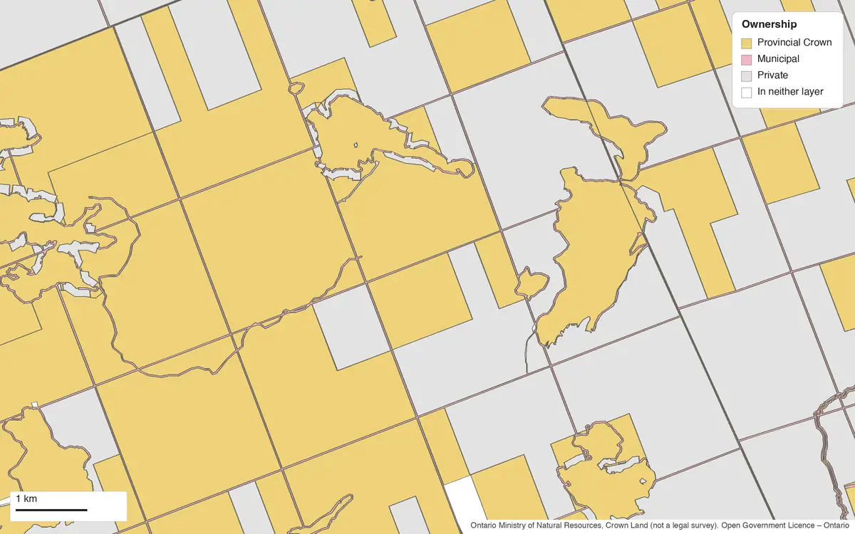
- Ontario Crown Land — the Ministry of Natural Resources' land ownership, from two layers in one: unpatented land, which is provincial Crown land, and patented land with the kind of title holder. Each piece has its Ownership (Provincial Crown, Crown Agency, Federal Crown, Municipal or Private), the Timber Reserved to the Crown on a patent where the Crown kept all the trees or the pine, and its Area (ha). The layer arrives colored by ownership. It's not a legal survey, and it says so. Ontario Ministry of Natural Resources, Crown Land – MNR Unpatented Land and Patent Land (not a legal survey). Contains information licensed under the Open Government Licence – Ontario.
- Ontario Land Use Policy (CLUPA) — the Crown Land Use Policy Atlas: what the province intends for each area of Crown land. Each area has its Designation (Provincial Park, Conservation Reserve, Wilderness Area, Provincial Wildlife Area, Forest Reserve, Enhanced Management Area, General Use Area and others), its Name, Category and its Policy ID in the Atlas. These areas are huge, so they're downloaded simplified to the scale of your map; zoom in for finer edges. Ontario Ministry of Natural Resources, Crown Land Use Policy Atlas (CLUPA), provincial policy areas. Contains information licensed under the Open Government Licence – Ontario.
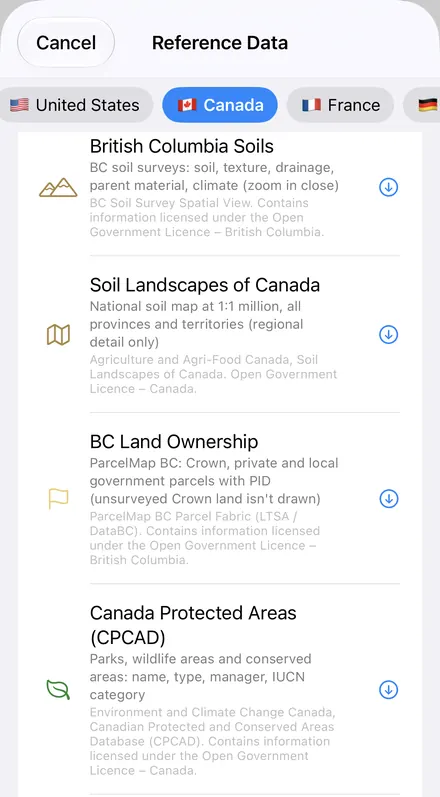
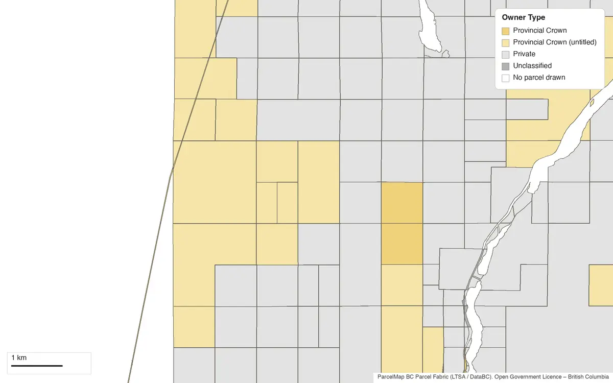
- BC Land Ownership — ParcelMap BC's parcel fabric: every surveyed parcel in the province, Crown and private, with its Owner Type, Parcel Class, PID for titled land, Crown Land PIN for Crown parcels, survey Plan, Municipality and Area (ha). It gives the type of owner, never a name. Crown land that has never been surveyed has no parcel, so it isn't drawn. ParcelMap BC Parcel Fabric (LTSA / DataBC). Contains information licensed under the Open Government Licence – British Columbia.
- Canada Protected Areas (CPCAD) — the Canadian Protected and Conserved Areas Database, for every province and territory: national and provincial parks, wildlife areas, ecological reserves and conserved areas, with their Name, Type, who they're Managed By, the Manager Type, the Owner, the IUCN Category, whether they're Protected or Conserved, the Year Established and the Area (ha). The layer arrives colored by manager type, with Parks Canada on its own. Like CLUPA, it's downloaded simplified to your map's scale. Environment and Climate Change Canada, Canadian Protected and Conserved Areas Database (CPCAD). Contains information licensed under the Open Government Licence – Canada.
The Colors
The land layers share one set of colors, so a glance tells you the same thing in Ontario and BC. Open public land is yellow.
| Ownership or Owner Type | In |
|---|---|
| Provincial Crown | Ontario, BC |
| Provincial Crown (untitled) | BC |
| Crown Agency | Ontario, BC |
| Federal Crown | Ontario, BC |
| Municipal / Local Government | Ontario, BC |
| First Nations | BC |
| Private | Ontario, BC |
In the protected areas layer, Parks Canada is purple, other federal areas such as wildlife areas orange, provincial and territorial parks and reserves blue, and Indigenous-managed areas tan. Tap any area for its name and type, or change the legend to color by any other column.
What the Map Doesn't Tell You
A Crown land layer answers one question: who holds this land? It doesn't answer the one you'll be asked in the field: may I be here, and do what? Before a trip, keep in mind:
- The rules are provincial. Each province sets its own rules for camping on Crown land (how long you may stay at one site, and whether you need a permit, which in Ontario can depend on whether you're a resident), for hunting and fishing seasons and zones, for fires and for off-road vehicles. Check the province's current rules; GoGIS doesn't carry them.
- Crown land can be spoken for. Leases, licences of occupation, land use permits, traplines, grazing and forestry tenures and mining claims sit on Crown land without changing its color here. A cabin or a gate on yellow land may be perfectly legal.
- Parks and reserves have their own rules. In Ontario, the CLUPA layer shows where Crown land is a park, a conservation reserve or a general use area. Everywhere in Canada, the CPCAD layer shows the protected and conserved areas. Hunting, camping and vehicle rules in them differ from the land around them.
- Getting there is a separate question. Crown land behind private land isn't reachable by crossing that land without permission. The map shows the private lots; it can't show a right of way.
- First Nations land and rights. Reserves, treaty and title lands and Indigenous-managed areas have their own rules. BC's layer marks First Nations parcels; CPCAD marks Indigenous-managed protected areas. Neither shows every right on the land.
- Not a survey. Lines can be off on the ground, and ownership changes. Use the map to know roughly where you are, and confirm on the ground.
Other Provinces
GoGIS has no Crown land layer for Alberta, Saskatchewan, Manitoba, Quebec, the Atlantic provinces or the territories yet. Everywhere in Canada you can still download:
- Canada Protected Areas (CPCAD), for parks, wildlife areas and reserves in every province and territory.
- Soil maps for Ontario, Alberta, Saskatchewan, Manitoba and BC, and the Soil Landscapes of Canada nationwide. See Canadian soil maps on iPhone and iPad.
- OpenStreetMap roads, rivers, buildings and land use: roads, tracks and paths, including the forest and resource roads mappers have added. See OpenStreetMap data on iPhone and iPad.
- Your own maps: a provincial land layer you've downloaded as a shapefile, GeoPackage or KML opens on the same map. See getting started with your data.
How to Download It
- Move the map to your area while you have signal. Search for a town, a lake or an address, or pan and zoom. GoGIS downloads what's on the screen.
- Open Reference Data. Tap Import, then Reference Data. The list opens on the country the map is showing, so with the map in Canada, the Canada datasets come first. Datasets that don't cover your map, such as Ontario's in BC, are greyed out and listed last.
- Choose a dataset. Progress shows on the map. If an area holds a great many features, GoGIS tells you how many and asks before it downloads them. Download the protected areas too, for the park and reserve names.
- Head out. The layers stay on your iPhone or iPad. Tap anywhere to see whose land it is.
On the welcome screen, Maps of Where I Am opens Reference Data straight onto the area around you.
Put It to Work
- Look through it in a table. Open a layer's attribute table to filter Ontario's land to Provincial Crown, list the protected areas by IUCN category, or total Area (ha) for what you filtered with a column summary; the attribute table on iPhone and iPad shows how.
- Mark what you find. Drop points for a campsite, a stand, a blocked road or a boat launch, with photos and notes, on your own layer. See GPS field data collection.
- Take it offline. See offline maps for fieldwork for preparing an area before you lose signal.
- Share the plan. Export the layers as a Shapefile, GeoPackage, KML, GeoJSON or CSV, or print a PDF map for the truck. The source credit the licence asks for goes with the export and on the print.
In the United States? The dispersed camping map shows BLM land and national forest the same way, colored by who manages it. For the rest of the world, see Reference Data by country.
Questions
Is the data in French?
The dataset names and descriptions are, when the app is in French. Ontario's land use policy areas (designations, names and categories) and the protected area names come in French too, as their publishers give them. The other columns are in English, as the provinces publish them.
What does "Provincial Crown (untitled)" mean in BC?
It's provincial Crown land that has a surveyed parcel but no registered title. It's still Crown land; it's simply recorded differently from Crown land with a title.
What's "Timber Reserved to the Crown" in Ontario?
Some Ontario patents kept the trees, or just the pine, for the Crown when the land was granted. The column shows where the patent layer records that. It's history worth knowing on a woodlot, not a rule about walking there.
Do I need an account or desktop GIS?
No. GoGIS downloads straight from the public services. There's no key, no account and nothing to unzip.
Know whose land you're on
Ontario Crown land, BC land ownership and Canada's protected areas, ready to download on your iPhone or iPad before you lose signal.
Get GoGIS on the App Store Get GoGIS on Google Play