Denmark's Soil Map on Your iPhone & iPad
Danish farmland is classified by its topsoil into the twelve JB classes (jordbundsklassifikation), from coarse sand through loam and clay to humus. The JB number is the shorthand Danish agronomy uses for a field's soil, in fertiliser and irrigation planning among much else. The Danish Agricultural Agency (Landbrugsstyrelsen) publishes the national soil map, the Jordbundskort, as open data under CC0.
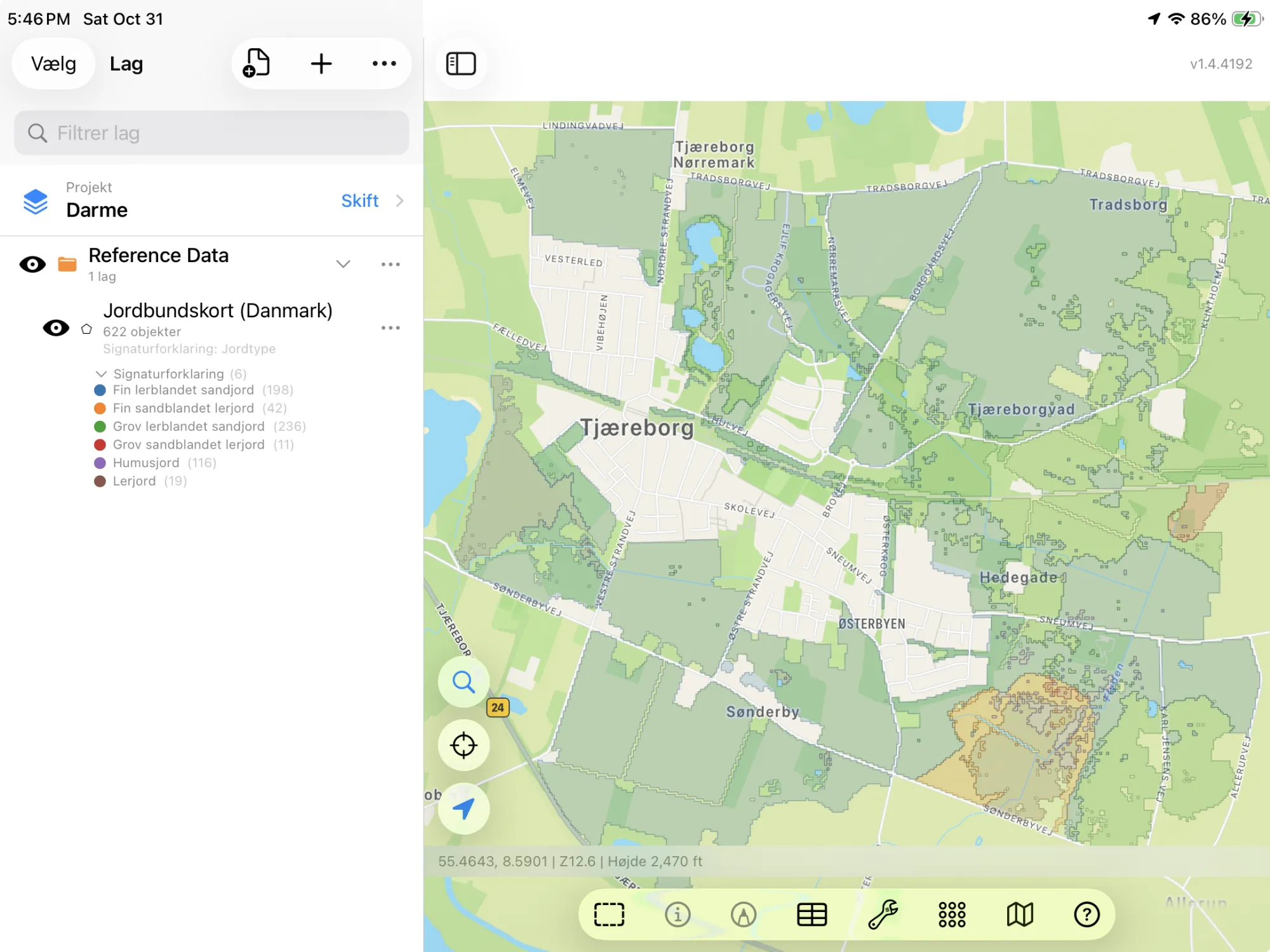
GoGIS now has a Denmark section in Reference Data. Move the map to your area, pick the soil map, and it downloads as a layer on your iPhone or iPad, colored by soil type: in Danish when the app is in Danish, in English otherwise.
What you can do with it in GoGIS
Download the data oncePick the layers you need from Reference Data. They stay on your phone and work with no signal.

Tap the map, even with no signalRead everything the publisher records about the parcel, field or area under your finger.

Photos, sketches and notesTake a picture where you stand, sketch on the map, and write down what you saw.

Your photos on the mapSee every photo where you took it, and share a PDF report of the place and your notes.
The Danish Dataset
- Denmark Soil Map — the Jordbundskort 2024: each polygon's soil type and its JB number. The layer arrives colored by soil type. Landbrugsstyrelsen – Jordbundskort 2024. CC0 1.0.
The Twelve JB Classes
With GoGIS in Danish, the columns are Jordtype and JB-nr., with the soil types named as Landbrugsstyrelsen names them. In any other language they're Soil Type and JB Class, with the soil types in English. The JB number is the same in both.
| JB | Soil type | Jordtype |
|---|---|---|
| JB 1 | Coarse sandy soil | Grovsandet jord |
| JB 2 | Fine sandy soil | Finsandet jord |
| JB 3 | Coarse loamy sand | Grov lerblandet sandjord |
| JB 4 | Fine loamy sand | Fin lerblandet sandjord |
| JB 5 | Coarse sandy loam | Grov sandblandet lerjord |
| JB 6 | Fine sandy loam | Fin sandblandet lerjord |
| JB 7 | Loam | Lerjord |
| JB 8 | Heavy loam | Svær lerjord |
| JB 9 | Very heavy loam | Meget svær lerjord |
| JB 10 | Silt | Siltjord |
| JB 11 | Humus soil | Humusjord |
| JB 12 | Special soil type | Speciel jordtype |
How to Download the Layers
- Move the map to your area. Search for a town or an address, or pan and zoom to the land you want. GoGIS downloads what's on the screen.
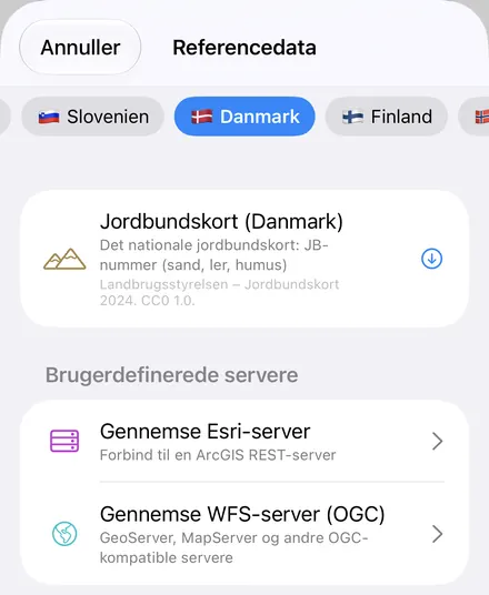
- Open Reference Data. Tap Import, then Reference Data. The row of countries along the top opens on the one the map is showing, so with the map in Denmark, the Denmark datasets are the ones listed.
- Choose a dataset. The download keeps going if you switch apps or the screen would otherwise lock, and progress shows on the map. When an area holds a great many features, GoGIS tells you how many and asks before it downloads them.
- Read the map. The soil map arrives colored by soil type. Tap anything to see everything about it.
Put the Layer to Work
- Filter by JB class. In the soil map's attribute table, filter the polygons by JB class or soil type, sort them, and export what you filtered as a CSV that Excel opens. How it works: the attribute table on iPhone and iPad.
- Know a field's JB number. Tap the ground under a field for its soil type and JB class, offline once the layer is downloaded.
- Read the soil across a farm. Use Intersect to cut your field boundaries by soil type and see how much of each field is sand, loam or humus.
- Plan sampling. Lay a sampling grid over the soil map so every soil type gets its samples.
- Export or print. Share the layer as a Shapefile, GeoPackage, KML, GeoJSON or CSV, or print a PDF map. The source credit goes on the print and with the export.
Elsewhere in the Nordics? Reference Data also has Sweden's crop fields and soil map, the German cadastre and crop fields, Finland's crop parcels and cadastre, Norway's property parcels, with five more countries' cadastres, and OpenStreetMap roads, rivers, buildings and land use anywhere.
Questions
Does GoGIS have Denmark's field blocks, crop fields or cadastre?
No. The published licence records for the field blocks disagree with each other, no licence could be found for the crop fields, and the cadastre needs a key. The soil map is CC0, so it's included.
What does the JB number measure?
The texture of the topsoil: how much clay, silt and fine and coarse sand it holds, and for JB 11 how much humus. JB 1 is coarse sand, JB 7 to 9 are loams, and JB 12 covers special soil types.
Can I use the layer offline and export it?
Yes. Once downloaded, the layer is stored on your iPhone or iPad and works without a connection. It exports as a Shapefile, GeoPackage, KML, GeoJSON or CSV, with the source credit.
Do I need desktop GIS software, an account or an API key?
No. GoGIS downloads from the Danish agriculture ministry's open service. There's no key, no account and nothing to unzip.
Denmark's soils, in your pocket
The Jordbundskort with every JB class, in Danish or English, ready to download on your iPhone or iPad.
Get GoGIS on the App Store Get GoGIS on Google Play