Finland's Crop Parcels, Cadastre & Soil Maps on Your iPhone & iPad
Ruokavirasto, the Finnish Food Authority, publishes every crop parcel (kasvulohko) declared for farm subsidies, with its crop named in both Finnish and Swedish. The National Land Survey of Finland (Maanmittauslaitos) publishes the cadastral parcels of every property unit, and the Geological Survey of Finland (GTK, Geologian tutkimuskeskus) its soil maps (maaperäkartta). All are open data under CC BY 4.0.
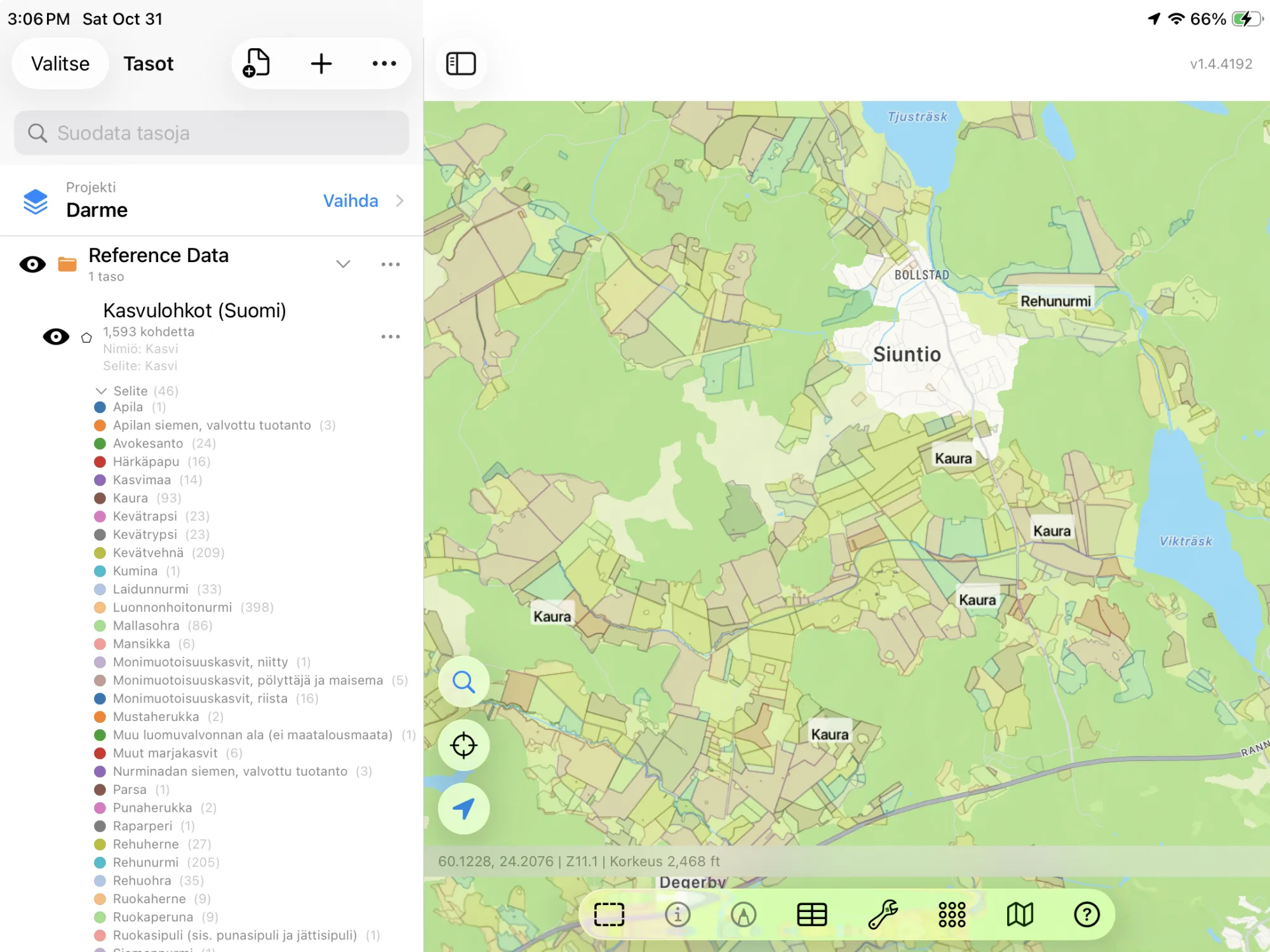
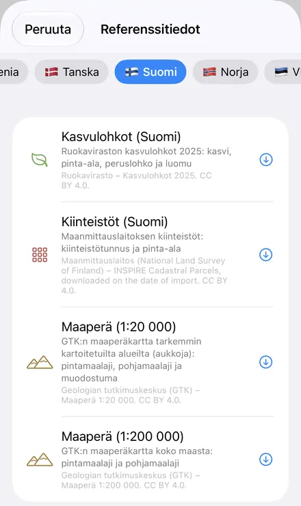
GoGIS now has a Finland section in Reference Data. Move the map to your area, pick a dataset, and it downloads as a layer on your iPhone or iPad, with areas in hectares: in Finnish when the app is in Finnish, in Swedish when it's in Swedish, with English column names otherwise.
What you can do with it in GoGIS
Download the data oncePick the layers you need from Reference Data. They stay on your phone and work with no signal.

Tap the map, even with no signalRead everything the publisher records about the parcel, field or area under your finger.

Photos, sketches and notesTake a picture where you stand, sketch on the map, and write down what you saw.

Your photos on the mapSee every photo where you took it, and share a PDF report of the place and your notes.
The Four Finnish Datasets
- Finland Crop Parcels — the crop parcels declared in 2025: each parcel's crop (Rehuohra, Kaura, Kevätvehnä, Rehunurmi), its crop code, its area in hectares, the ID of the field block (peruslohko) it lies in, whether it's farmed organically, and the year. No farmers' names. The layer arrives colored and labeled by crop. Ruokavirasto – Kasvulohkot 2025. CC BY 4.0.
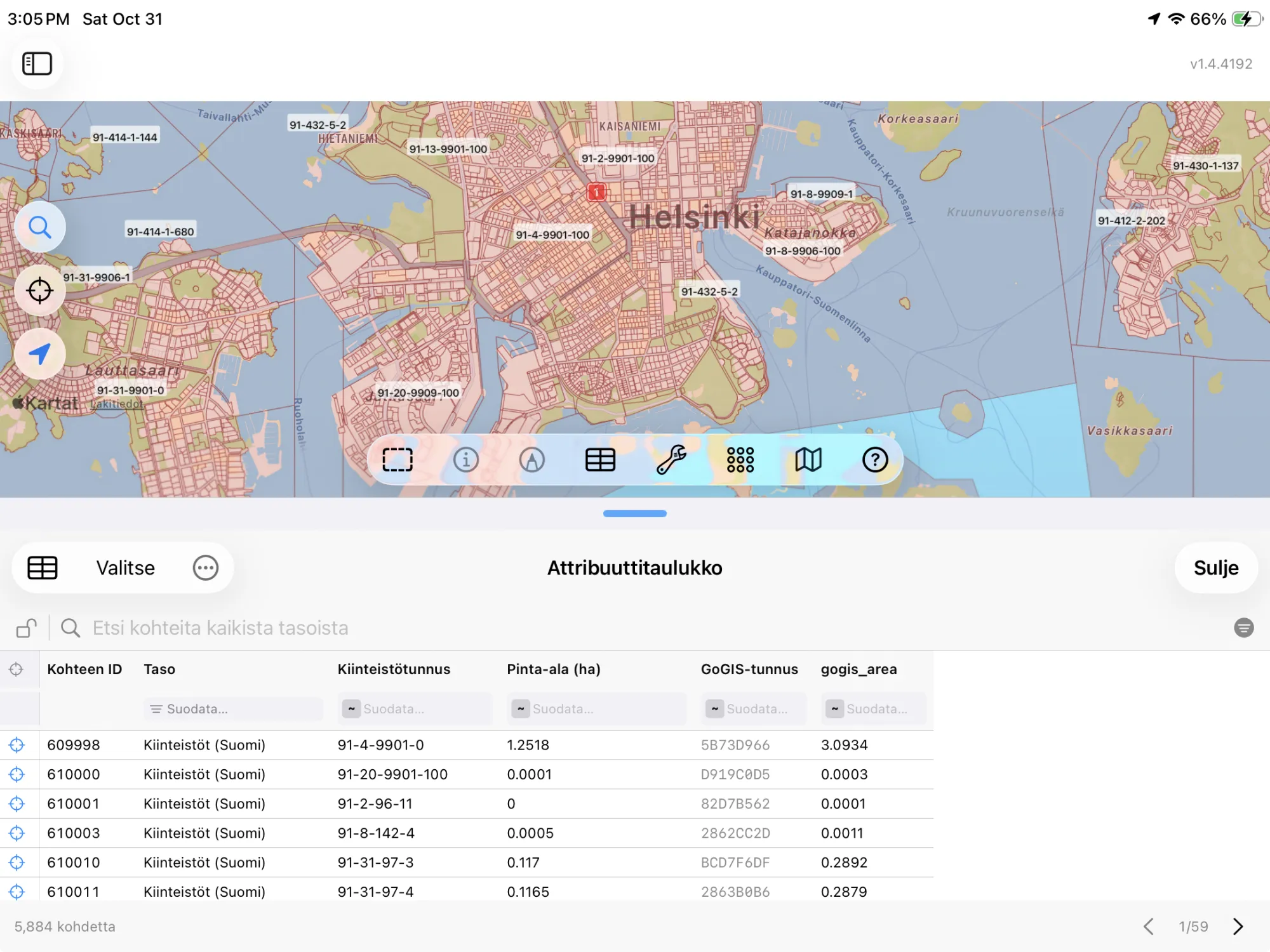
- Finland Cadastral Parcels — the National Land Survey's cadastral parcels, each with its property unit's ID (430-401-2-223: municipality, village, house and register number) and its area in hectares, measured from the outline. The layer arrives labeled by property ID. Maanmittauslaitos (National Land Survey of Finland) – INSPIRE Cadastral Parcels, downloaded on the date of import. CC BY 4.0.
- Finland Soils (1:20,000) — GTK's detailed soil map, where it has been made: each area's surface soil, the subsoil beneath it, the landform it belongs to (an esker or delta, an ice-marginal formation) and its map symbol, such as Ct/Sa for sedge peat over clay. The layer arrives colored by surface soil and labeled by map symbol. It has gaps: in a 15 by 17 km box over Helsinki it held 188 areas covering about 57 km², a quarter of them marked Not mapped. Geologian tutkimuskeskus (GTK) – Maaperä 1:20 000. CC BY 4.0.
- Finland Soils (1:200,000) — GTK's soil map of the whole country: each area's surface soil and subsoil, colored by surface soil. Geologian tutkimuskeskus (GTK) – Maaperä 1:200 000. CC BY 4.0.
Each soil comes with its name and GTK's symbol, in the Finnish geotechnical classes: Clay (Sa), Silt (Hs), Coarse silt (HHt), Fine sand (KHt), Sandy till (Mr), Sedge peat (Ct), Bedrock outcrop (KaPa), and the gyttja-bearing clays and silts of the coast. The colors follow the soil, from the blues of clay and silt to the browns of peat, so the pattern of a parish reads at a glance.
Finnish, Swedish or English
With GoGIS in Finnish, the columns are Kasvi, Kasvikoodi, Pinta-ala (ha), Peruslohko, Luomu and Vuosi, and the cadastre's Kiinteistötunnus. In Swedish they're Gröda, Grödkod, Areal (ha), Basskifte, Ekologisk, År and Fastighetsbeteckning, and every crop has its Swedish name from Ruokavirasto (Foderkorn, Havre, Vårvete). In any other language the columns are in English (Crop, Crop Code, Area (ha), Field Block, Organic, Year, Property ID) and the crops keep their Finnish names, with the crop code alongside.
The soil maps follow the same rule: Pintamaalaji, Pohjamaalaji, Muodostuma and Tunnus in Finnish (Savi (Sa)), Ytjordart, Underliggande jordart, Bildning and Symbol in Swedish (Lera (Sa)), and Surface Soil, Subsoil, Landform and Map Symbol in English and every other language (Clay (Sa)).
How to Download the Layers
- Move the map to your area. Search for a town or an address, or pan and zoom to the land you want. GoGIS downloads what's on the screen.
- Open Reference Data. Tap Import, then Reference Data. The row of countries along the top opens on the one the map is showing, so with the map in Finland, the Finland datasets are the ones listed.
- Choose a dataset. The download keeps going if you switch apps or the screen would otherwise lock, and progress shows on the map. When an area holds a great many features, GoGIS tells you how many and asks before it downloads them.
- Read the map. Crop parcels arrive colored and labeled by crop, the cadastre labeled by property ID, the soil maps colored by surface soil. Tap anything to see everything about it. A soil map comes in one request of up to 100,000 areas; if your area holds more, GoGIS asks you to zoom in.
Put the Layers to Work
- Add up the crops. In the crop parcels' attribute table, filter Crop to Kaura or show only the organic parcels, total their hectares with a column summary, and export the list as a CSV that Excel opens. Details in the attribute table on iPhone and iPad.
- See what's grown around you. The crop parcels show the 2025 cropping at a glance: feed barley, oats, spring wheat and grass, and which parcels are organic.
- Read the soil under a field. Lay a crop parcel over the soil map before you sample, drain or lime: clay, silt or peat, and what lies beneath it.
- Find a property's ID in the field. Stand on the land with your GPS position on the map and tap: the property ID is there, with or without a signal once the layer is downloaded.
- Combine them with your own data. Use Intersect to cut the crop parcels by property, or lay your own sample points over them.
- Export or print. Share any layer as a Shapefile, GeoPackage, KML, GeoJSON or CSV, or print a PDF map. Each source's credit goes on the print and with the export.
Elsewhere in the Nordics and Baltics? Reference Data also has Sweden's crop fields and soil map, Norway's property parcels, with five more countries' cadastres, Estonia's cadastre, field blocks and crop fields, Latvia's field blocks, crops and parcels, Iceland's parcels, soils and vegetation, and OpenStreetMap roads, rivers, buildings and land use anywhere.
Questions
Do the layers show the owners or the farmers?
No. The cadastral parcels carry the property ID and area, and the crop parcels the crop and area; neither names a person.
Why does a property have several parcels?
A Finnish property unit can be made of several separate pieces of land. Each piece is its own parcel on the map, and they share the property ID.
Why are the crops in Finnish when the app is in English?
Ruokavirasto's layer names each crop in Finnish and Swedish. GoGIS shows the Finnish name, or the Swedish one with the app in Swedish, and keeps the crop code in its own column so every parcel can be matched to the official list.
Why are there two soil maps?
Because they differ. The 1:20,000 map is the detailed one, with landforms, but it has been made only in parts of the country, so it has gaps. The 1:200,000 map covers all of Finland in less detail. GoGIS keeps them apart so you always know which one you're reading.
Do I need desktop GIS software, an account or an API key?
No. GoGIS downloads from Ruokavirasto's, the National Land Survey's and GTK's open services. There's no key, no account and nothing to unzip.
Finland's fields, properties and soils, in your pocket
Ruokavirasto's crop parcels, the National Land Survey's cadastre and GTK's soil maps, ready to download on your iPhone or iPad.
Get GoGIS on the App Store Get GoGIS on Google Play