Hungary's Protected Kurgans (Kunhalmok) on Your iPhone & iPad
Low earth mounds rise out of the fields of the Great Hungarian Plain. Hungarians call them kunhalmok, "Cuman mounds", though they're far older than the Cumans. Many are burial mounds, or kurgans, raised by peoples of the steppe, and some of those go back to the Yamnaya, who reached the plain around the turn of the Copper and Bronze Ages. Others served as lookouts or marked boundaries. On some farmland, the steep sides of the mounds hold the last remnants of the old grassland and its wildlife.
Hungarian law protects every kunhalom, and the Lechner Knowledge Center (Lechner Tudásközpont) publishes the national record of them as open data under CC BY 4.0. GoGIS now has a Hungary section in Reference Data with that record as Protected Kurgans (Kunhalmok): 1,563 mounds you can see on your iPhone or iPad, over your own fields and offline.
What you can do with it in GoGIS
Download the data oncePick the layers you need from Reference Data. They stay on your phone and work with no signal.

Tap the map, even with no signalRead everything the publisher records about the parcel, field or area under your finger.

Photos, sketches and notesTake a picture where you stand, sketch on the map, and write down what you saw.

Your photos on the mapSee every photo where you took it, and share a PDF report of the place and your notes.
Protected by Law
Hungary's nature conservation act, Act LIII of 1996 (1996. évi LIII. törvény a természet védelméről), protects every kunhalom by the force of the act itself, ex lege, with no decree needed for each mound. That's section 23 (2), which covers springs, bogs, caves, sinkholes, soda lakes and earthwork forts in the same way. All of these count as protected areas of national importance.
- What counts as a kunhalom. Section 23 (3) f) defines it as a convex earthwork that matters for its cultural history, cultural heritage, landscape or wildlife, and which stands out enough to shape the landscape around it.
- A natural monument. Under section 28 (5), a protected kunhalom is a természeti emlék, a natural monument.
- No changing it. Section 31 forbids changing a protected area's state or character against the aims of conservation.
- Permits. Section 38 (1) lists work on a protected area that needs the nature conservation authority's permit. The list includes breaking up or reseeding its grassland, changing its use or its cultivation, using pesticides or chemicals that affect the soil's fertility, and driving on it off the designated farm roads.
Farm payments add rules of their own. A leaflet for farmers on the ministry's nature conservation site, Értékőrző gazdálkodás – kunhalmok a tájban, says that about 1,000 kunhalmok are registered as protected landscape features. On those, farm payment conditions (HMKÁ, Hungary's good agricultural and environmental condition rules) forbid agricultural soil work, except to prepare for sowing grass. They also forbid disturbing the mound's soil when trees are felled. The leaflet adds that taking a mound out of cultivation doesn't reduce the area eligible for payment. The 2026 glossary of Hungary's agri-environment scheme still lists the kunhalom among the protected landscape features. Check the current farmer's handbook (Gazdálkodói Kézikönyv) for the rules that apply this year.
The Hungarian Dataset
- Protected Kurgans (Kunhalmok): called Ex lege védett kunhalmok when the app is in Hungarian. Hungary's ex lege protected kurgans, one point per mound, from the national nature conservation records kept by the Ministry for the Living Environment and published by the Lechner Knowledge Center for INSPIRE and the EU's high-value datasets. Ex lege védett kunhalmok – © Lechner Tudásközpont / EKFM, CC BY 4.0.
Each mound carries four columns:
| Column | In the file | What it holds |
|---|---|---|
| Name | KH_NEV | The mound's name, such as Zádor-halom or Csípő-halom. Paired mounds are told apart by number or direction (Kettős-halom I., Kettős-halom É). 35 mounds have no name and read anonym. |
| Settlement | telep | The settlement it belongs to. A mound on a boundary can name two or three. |
| National park directorate | NPI | The national park directorate that looks after it, by its abbreviation (below). |
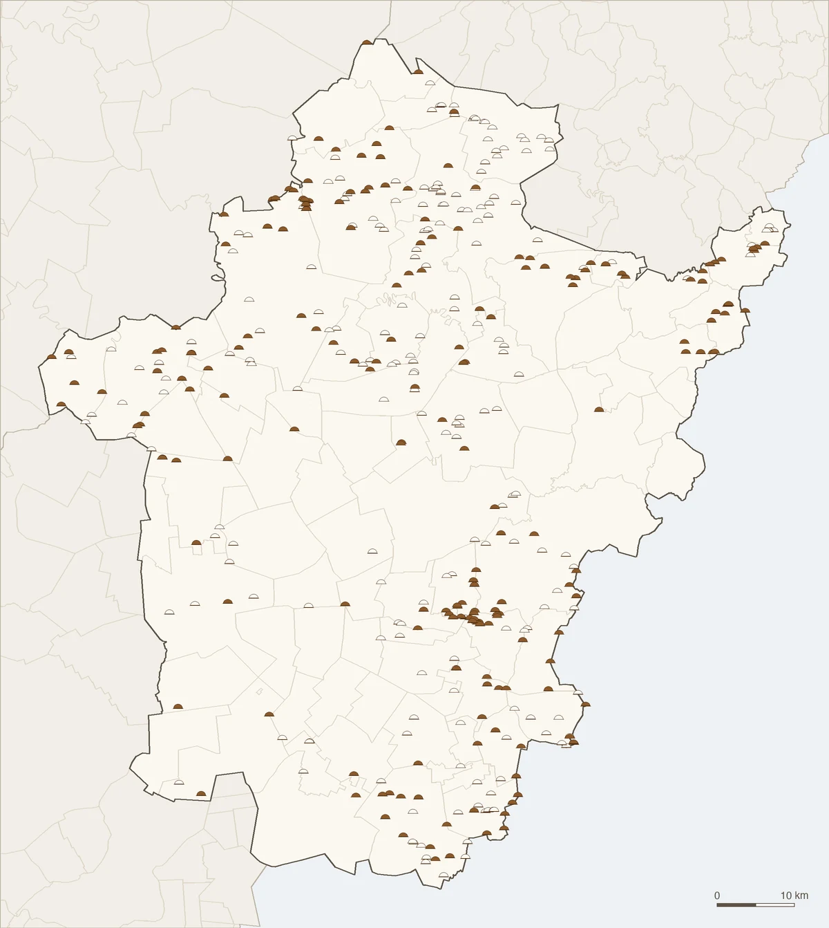
| In MePAR | mepar | Whether the mound is in MePAR, the land parcel identification system behind farm payments: I (igen, yes) for 987 mounds, N (nem, no) for 576. |
The Ten Directorates
| Code | National park directorate | Mounds |
|---|---|---|
| KMNPI | Körös–Maros | 589 |
| HNPI | Hortobágy | 549 |
| KNPI | Kiskunság | 171 |
| BNPI | Bükk | 118 |
| DINPI | Duna–Ipoly | 63 |
| BfNPI | Balaton-felvidék | 25 |
| FHNPI | Fertő–Hanság | 18 |
| DDNPI | Duna–Dráva | 16 |
| ANPI | Aggtelek | 11 |
| ŐNPI | Őrség | 3 |
Where the Mounds Are
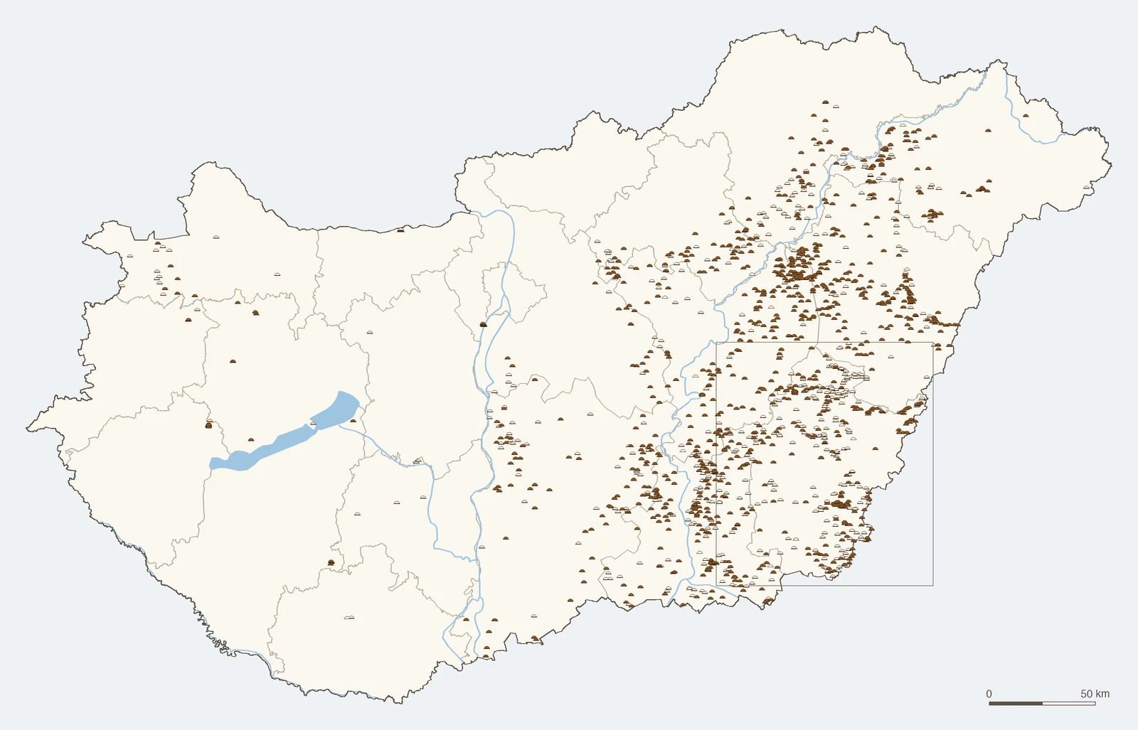
Almost all of them are on the plain east of the Danube. By county, measured against Lechner's 2025 county boundaries:
- Békés: 400
- Csongrád-Csanád: 248
- Hajdú-Bihar: 232
- Jász-Nagykun-Szolnok: 225
- Bács-Kiskun: 110
- Szabolcs-Szatmár-Bereg: 94
- Borsod-Abaúj-Zemplén: 70
- Heves: 60
- Pest: 58
- The other nine counties: 66 between them
The mounds belong to 379 settlements. Hódmezővásárhely has the most, 36, then Szentes with 35 and Tiszafüred with 33.
How to Download the Layer
- Move the map to Hungary. Search for a town or an address, or pan and zoom to the land you want.
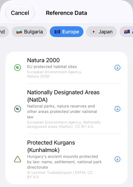
- Open Reference Data. Tap Import, then Reference Data. The row of countries along the top opens on the one the map is showing, so with the map in Hungary, the Hungary datasets are the ones listed.
- Choose Protected Kurgans (Kunhalmok). The download keeps going if you switch apps or the screen would otherwise lock, and progress shows on the map.
- Read the map. Tap a mound to see its name, settlement, directorate and whether it's in MePAR.
Put the Layer to Work
- List the mounds in a table. In the layer's attribute table, filter the mounds by settlement or directorate, show only the ones in MePAR, and export that list as a CSV that Excel opens. See the attribute table on iPhone and iPad.
- Know where the mounds are before you go out. Once downloaded, the layer works offline. Your GPS position shows on the same map, so you can see how close you are to a mound in the middle of a field, before you plough, spray or drive across it.
- Lay it over your fields. Open your own field boundaries as a Shapefile, KML or GeoPackage and see which of your fields hold a mound. Use Buffer to draw a margin around each one and keep it in view while you work.
- Add the other layers for Hungary. Reference Data's Europe section has Natura 2000, the EU's protected habitat sites. OpenStreetMap roads, rivers, buildings and land use work anywhere.
- Record what you find. Walk a mound and note its state, its grassland or any damage in a layer of your own, with forms and photos. See GPS field data collection.
- Export or print. Share the layer as a Shapefile, GeoPackage, KML, GeoJSON or CSV, or print a PDF map. The source credit goes on the print and with the export.
Elsewhere in Central Europe? Reference Data also has Austria's INVEKOS fields and soil map, the Czech cadastral map, Slovenia's land cadastre, and every other country in Reference Data by country.
Questions
Is a mound protected only if it's in the layer?
No. The protection comes from the 1996 nature conservation act itself, which covers every kunhalom. The layer is the official record of them. If you're unsure about a mound, ask the national park directorate it belongs to.
What does In MePAR mean?
Whether the mound is in MePAR, the land parcel identification system behind Hungary's farm payments: I (igen) for yes, N (nem) for no. 987 of the 1,563 mounds are marked I. The MePAR portal shows the mounds registered as protected landscape features on its own map.
Does the layer show how big each mound is?
No. Each mound is a single point, at the mound, with no outline, height or area.
Can I use the layer offline and export it?
Yes. Once downloaded, the layer is stored on your iPhone or iPad and works without a connection. It exports as a Shapefile, GeoPackage, KML, GeoJSON or CSV, with the source credit.
Do I need desktop GIS software, an account or an API key?
No. GoGIS takes the layer from the Lechner Knowledge Center's open data. There's no key, no account and nothing to unzip or convert.
Sources: Act LIII of 1996 on nature conservation, sections 23, 28, 31 and 38, as in force in November 2026; the leaflet Értékőrző gazdálkodás – kunhalmok a tájban (termeszetvedelem.hu); the 2026 agri-environment scheme glossary (kap.gov.hu); Lechner's metadata for Ex lege protected kurgans (kunhalmok) of Hungary; Gerling et al., "Immigration and transhumance in the Early Bronze Age Carpathian Basin: the occupants of a kurgan", Antiquity 86 (2012). This page explains the data. It isn't legal advice.
Hungary's kunhalmok, in your pocket
Every protected mound in the national record, ready to download on your iPhone or iPad.
Get GoGIS on the App Store Get GoGIS on Google Play