The Italian Cadastral Map on Your iPhone & iPad
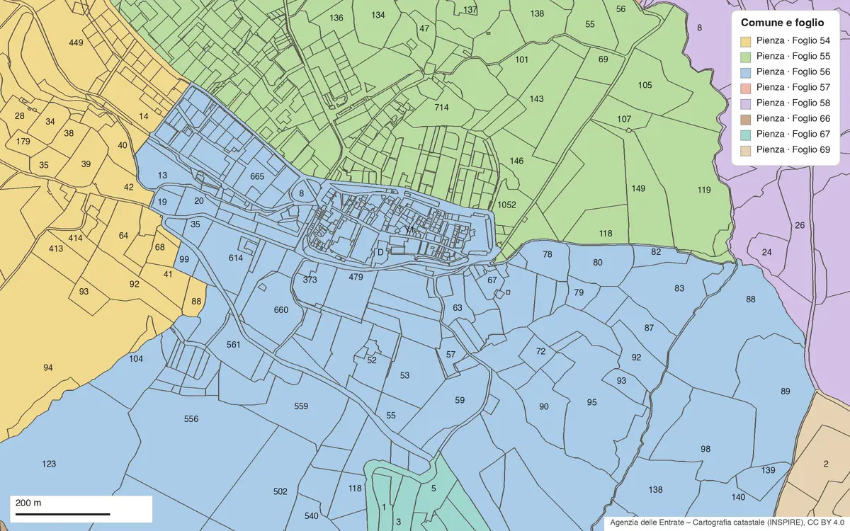
Every piece of land in Italy has a cadastral address: the comune, the foglio (the sheet of the comune's cadastral map) and the particella (the parcel's number on that sheet). It's how a parcel is named in a deed, a sale listing, a farm plan or an inheritance, and it's often all you're given. Finding that parcel on the ground is another matter.
The Agenzia delle Entrate publishes the cadastral map (mappa catastale) as open data. GoGIS has an Italy section in Reference Data that downloads it onto your iPhone or iPad. Move the map to the place, pick the dataset, and the parcels arrive as a layer, each with its comune, province, foglio, particella and area. Then walk to the parcel with your GPS position on the same map, with or without signal.
What you can do with it in GoGIS
Download the data oncePick the layers you need from Reference Data. They stay on your phone and work with no signal.

Tap the map, even with no signalRead everything the publisher records about the parcel, field or area under your finger.

Photos, sketches and notesTake a picture where you stand, sketch on the map, and write down what you saw.

Your photos on the mapSee every photo where you took it, and share a PDF report of the place and your notes.
The Two Italian Datasets
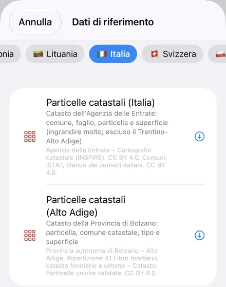
- Italy Cadastral Parcels — the Agenzia delle Entrate's cadastral map, everywhere in Italy except Trentino-Alto Adige. Each parcel has its Municipality (the comune, by name, from ISTAT's list), Province, Sheet (Foglio), Parcel (Particella), the full Cadastral Reference and its Area (ha). Parcels are labeled with their particella number. Roads and waters, which the cadastre numbers as
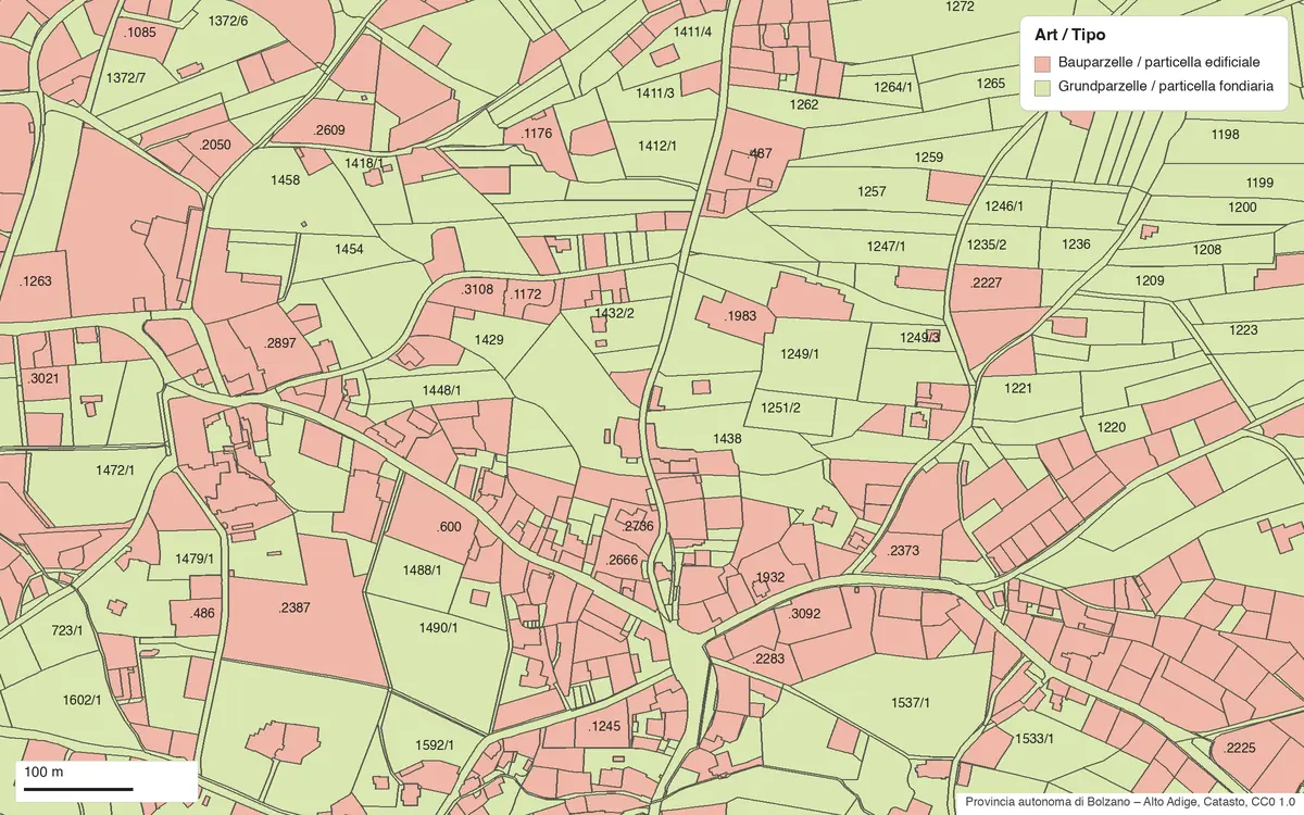
STRADA001orACQUA012, read as Road and Water. Where a sheet has an annex (allegato), a development (sviluppo) or a section (sezione), it's written the way a visura writes it: 12 Allegato A. Agenzia delle Entrate – Cartografia catastale (INSPIRE). CC BY 4.0. Comuni: ISTAT, Elenco dei comuni italiani. CC BY 4.0. - South Tyrol Cadastral Parcels — in the Province of Bolzano the cadastre is kept by the province, and GoGIS reads its validated parcels directly. Each has its Parcel number, Cadastral Municipality, Municipality, Type (land parcel or building parcel), Area (ha) and the date it was Updated. Names come in both languages, Italian and German, where they differ. Provincia autonoma di Bolzano – Alto Adige, Ripartizione 41 Libro fondiario, catasto fondiario e urbano – Catasto: Particelle uniche validate. CC0 1.0.
In English or in Italian
With the app set to Italian, the national cadastre's columns are Italian: Comune, Provincia, Foglio, Particella, Riferimento catastale, Superficie (ha), and the dataset is called Particelle catastali (Italia). In every other language they're in English, with the Italian word kept beside it where it matters: Sheet (Foglio), Parcel (Particella). The cadastre's own words for annexes, developments and sections stay Italian in any language, because that's what the documents say.
South Tyrol's parcels follow the province's two languages: German columns when the app is in German (Parzelle, Katastralgemeinde, Gemeinde, Art, Fläche (ha)), Italian in Italian, English otherwise. Place names show both forms, the app's language first: Eppan an der Weinstraße / Appiano sulla Strada del Vino.
South Tyrol: Land Parcels and Building Parcels
South Tyrol numbers its parcels the Austrian way. Land parcels (Grundparzellen, particelle fondiarie) have plain numbers, often with a sub-number: 1372/6. Building parcels (Bauparzellen, particelle edificiali) start with a dot: .2050. Both are numbered within a cadastral municipality, which isn't always the same as the municipality, so the layer gives you both.
How to Download the Parcels
- Move the map to the place. Search for a comune or an address, or pan and zoom to the fields you want. GoGIS downloads what's on the screen. Zoom in close: Italian parcels are small, and a village with its fields is a good size.
- Open Reference Data. Tap Import, then Reference Data. The list opens on the country the map is showing, so with the map in Italy, Italy is at the top, with Europe next to it. A dataset that doesn't cover the area on your map is greyed out and listed last. In South Tyrol, pick South Tyrol Cadastral Parcels: the national map doesn't cover it.
- Choose the dataset. Progress shows on the map as the parcels come in. If an area holds a very large number of parcels, GoGIS tells you how many and asks before it downloads them.
- Tap a parcel. You see its comune, foglio, particella and area. Search the attribute table for a particella number, or filter it to one foglio.
On the welcome screen, Maps of Where I Am opens Reference Data straight onto the area around you.
The Server's Quirks, Handled for You
The Agenzia's service is built for small requests. It answers only for a small box at a time, so GoGIS cuts the area on your screen into tiles of about a kilometer and asks for four at once, keeping a parcel that straddles two tiles only once. It also turns down a share of requests for no reason it gives ("Richiesta non valida"), and the same request then succeeds. GoGIS asks again after a short wait, then with a box a hair wider, then in quarters, and only reports an error if every way has failed. You don't need to do anything but wait.
The limit this sets is size: one download covers up to about 100 tiles, roughly 10 × 14 km in the north. For a larger area, GoGIS says the area is too large and asks you to zoom in.
What the Parcels Are For
- Finding a parcel on the ground. You have comune, foglio and particella from a deed, a listing or a relative. Download the area, find the parcel, and walk to it with your GPS position on the map. Once downloaded, the layer works with no signal, in the hills as well as the town.
- Listing and sorting. Open the layer's attribute table to search for a particella, filter by foglio or municipality, sort by area, and export the rows as a CSV that Excel opens. See the attribute table on iPhone and iPad.
- Measuring. The area in the layer is measured from the parcel's outline on the map. For part of a parcel, or a field across several, use Measure Area and tap the corners: GoGIS gives the area and perimeter as you go.
- Field work. Record points, photos and notes with your own forms over the parcels, for an olive grove, a vineyard, a wood or a soil survey. See GPS field data collection.
- Sharing. Export the parcels as a Shapefile, GeoPackage, KML, GeoJSON or CSV, or print a PDF map. The source credit the licence asks for goes with the export and on the print.
What They Are Not
- Not a boundary survey. The cadastral map is what everyone uses to find a parcel, but where a boundary legally lies is for a surveyor (geometra) and the title documents to settle. The lines on the map and the fences on the ground don't always agree.
- Not a visura. The map has no owners, no cadastral income (rendita) and no classification, and neither does GoGIS. Those are in the visura catastale, which comes from the Agenzia delle Entrate.
- Not the official surface. The service publishes no area, so the national layer's area is measured from the outline. The figure on the visura may differ. South Tyrol's layer gives the area the province publishes.
- Not Trentino. The Province of Trento publishes its cadastre only as one download per comune, so GoGIS doesn't have it yet.
More Italian Data in GoGIS
- Natura 2000, in the Europe section: the EU's protected habitat sites, from the European Environment Agency. Useful to know before you plan work near a site of community importance.
- OpenStreetMap roads, rivers, buildings and land use, anywhere in Italy, as layers you can edit. See OpenStreetMap data on iPhone and iPad.
- Your own data: shapefiles, GeoPackage, KML and CSV from a surveyor, an agronomist or a regional geoportal open on the same map. See getting started with your data.
Elsewhere in Europe? See Reference Data by country, with the French cadastre and crop parcels, the German cadastre, Austria's fields and soils, Slovenia's land cadastre and more European cadastres.
Questions
Is it the same map as the Agenzia delle Entrate's online viewer?
It's the same cadastral map. The Agenzia shows it online and publishes it as open data (its INSPIRE service), and that's what GoGIS downloads, as a layer you can take offline, search and export.
Why do I need the foglio as well as the particella?
Particella numbers start again on every sheet, so the same number turns up several times in one comune. Comune, foglio and particella together identify a parcel; the Cadastral Reference column holds all three in the cadastre's own code.
Do I need an account, a key or desktop GIS?
No. GoGIS downloads the parcels straight from the public services. There's no key, no account and nothing to unzip.
Can I see who owns a parcel?
No. Neither the cadastral map nor GoGIS has owners. For that you need a visura from the Agenzia delle Entrate.
Italy's cadastral map, in your pocket
Comune, foglio and particella on the map, in English or Italian, ready to download on your iPhone or iPad.
Get GoGIS on the App Store Get GoGIS on Google Play