GIS Software for iPad and iPhone
If you're looking for GIS software for an iPad or an iPhone, you probably want one of two things. A way to open the files someone sent you, out where the work is. Or a way to do the work itself out there: collect, edit, measure, analyze, and send the result back to the office.
GoGIS does both. It runs on iPhone and iPad, on Android phones and tablets, and on Macs with Apple silicon. This page names the formats and the tools, so you can check them against your job before you install anything.
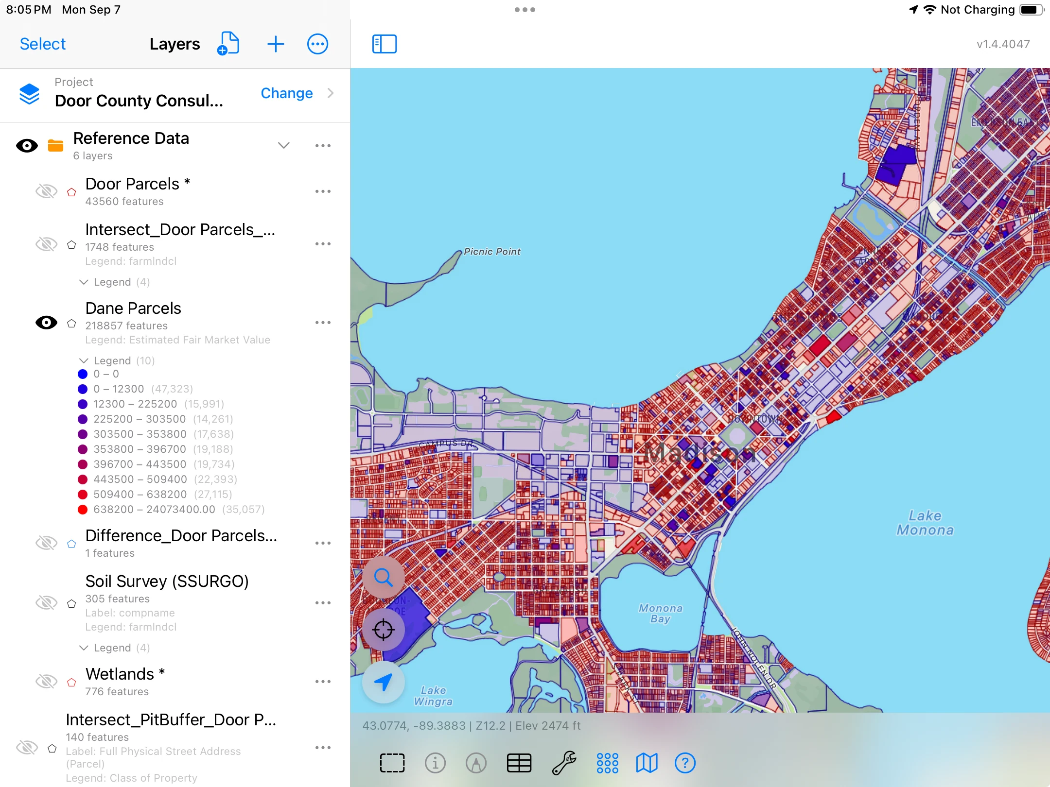
A GIS that fits in your pocket
GoGIS for iPhone, iPad and Android. Open your files, work on them in the field, and export the result.
Get GoGIS on the App Store Get GoGIS on Google PlayWhat to Look For in a GIS App for iPhone or iPad
A map app shows a map. A GIS app works with the data behind it: the shapes, and the table of facts about each one. Whatever app you try, these are the things worth checking.
- Real files in. It should open the files GIS people actually send, with every attribute, not just a picture of the shapes. In GoGIS: zipped shapefiles, GeoPackage, KML and KMZ, GeoJSON and CSV, plus GeoTIFF and MBTiles imagery. Files in and out
- Real files out. What you change in the field has to get back to the desktop in a format it reads. In GoGIS: Shapefile, GeoPackage, GeoJSON, KML and CSV, with photos in the same ZIP.
- Offline. Fieldwork happens where the signal doesn't. Check what still works in airplane mode: your layers, the GPS, collecting, the tools and the basemap. In GoGIS: everything but downloads and online services. What works offline
- Editing. Draw new points, lines and polygons, and change the attributes of the ones already there. In GoGIS: digitize all three, by GPS or by hand, and edit in a form or in the table.
- An attribute table. Every feature as a row and every attribute as a column. Sort, search, total, edit. In GoGIS: the Attribute Grid, with bulk edit and undo. The attribute table
- Analysis. Can it answer a question about where things are? What lies within a mile of a site? What's left of a field outside the wetland? In GoGIS: Buffer, Intersect, Difference and Dissolve, run on the device. Analysis
- Coordinate systems. County and state data is often projected. The app should read the projection, put the shapes in the right place, and write them back in the projection your office uses. In GoGIS: it reads a shapefile's .prj file and reprojects on the fly, and a shapefile export can be written in a coordinate system for your area, such as NAD83 / Wisconsin Central.
- Forms. Field records stay consistent when people pick from a list instead of typing. In GoGIS: custom forms with pick lists, photos, barcodes, signatures and formulas. Collecting
- Your data stays yours. It should live on your device and leave it when you decide, without an account. In GoGIS: no account, and nothing leaves the device until you export or sync it.
Files In and Out
GoGIS opens the common vector formats as layers you can tap, style, query and edit:
- Shapefile, as the usual ZIP of .shp, .shx, .dbf and .prj. GoGIS unzips it for you. How to open a shapefile
- GeoPackage (.gpkg). Each table in the file becomes its own layer. GeoPackage on iPhone and iPad
- KML and KMZ, keeping the colors, line widths and fills set in the file: they become the layer's legend, and the fields in each description table become columns. KML and KMZ viewer
- GeoJSON, and CSV with coordinate columns: GoGIS asks which columns hold them.
- Imagery: georeferenced GeoTIFF, such as a drone orthomosaic, and raster MBTiles, drawn in place over the basemap.
Files come in from the Files app, iCloud Drive, Google Drive, AirDrop or a mail attachment. Big ones are fine: GoGIS imports each layer into an indexed database on the device, so a county's parcels stay quick to pan and search. The Dane County layer above holds 218,857 parcels. See large shapefiles on iPhone and iPad.
Going back, GoGIS exports Shapefile, GeoPackage, GeoJSON, KML or CSV. Photos travel in the same ZIP. Repeat visits recorded in Related Forms export as CSV files that link back to their features by a shared ID; see linking Related Form CSVs. You can also make a PDF map with your layers, a legend and a scale.
The Map: Layers, Legends, Labels
Stack as many layers as the job needs: parcels at the bottom, flood zones over them, your own points on top. Turn each on and off, and change the order.
- Tap a feature to see every attribute it carries.
- Color by an attribute: one color per value, such as land use or soil type, or ranges for a number.
- Label by an attribute, such as parcel ID or sample number.
- Measure distances and areas.
- Add your own imagery and set its opacity to blend it with the basemap.
New to all this? New to GIS files? Start here explains features, attributes and the attribute table in plain words, and getting started with your data goes from a file in your inbox to a styled map.
The Attribute Table
Open a layer's menu and choose the Attribute Grid. Each row is a feature; each column is an attribute.
- Sort by tapping a column heading, and search across every column at once.
- Summarize a number column: sum, average, minimum and maximum of the rows you're looking at.
- Tap a row and the map goes to that feature.
- Edit a cell in place, without opening the form.
- Select several rows, choose a column and set one value for all of them. A selection can span layers. Undo is offered right after.
Three walkthroughs with free public data show it at work, from acres of almonds in Kern County to property tax in a Wisconsin town: what can you do with your GIS data? Every filter, the change to many rows at once and the CSV export for Excel are covered one task at a time in the attribute table on iPhone and iPad.
Analysis on the Device
Four geometry tools combine layers by where their shapes are. Each writes a new layer with its own table, which you can style, total and export like any other.
- Buffer: a zone at a set distance around points, lines or areas. Interactive Buffer lets you drag the distance and watch the ring change.
- Intersect: keep only where two layers overlap, with columns from both.
- Difference: take one layer out of another and keep what's left.
- Dissolve: merge shapes into one outline, or one per value of a column.
Run them on a whole layer from its menu, or on just the features you selected from the Tools menu. One example from a demonstration project: a one-mile buffer around a proposed pit, intersected with the county's parcels, gives 140 pieces of parcel, each still carrying its address, parcel ID and class. Another: a 39.97-acre parcel minus the mapped wetlands leaves 35.80 acres.
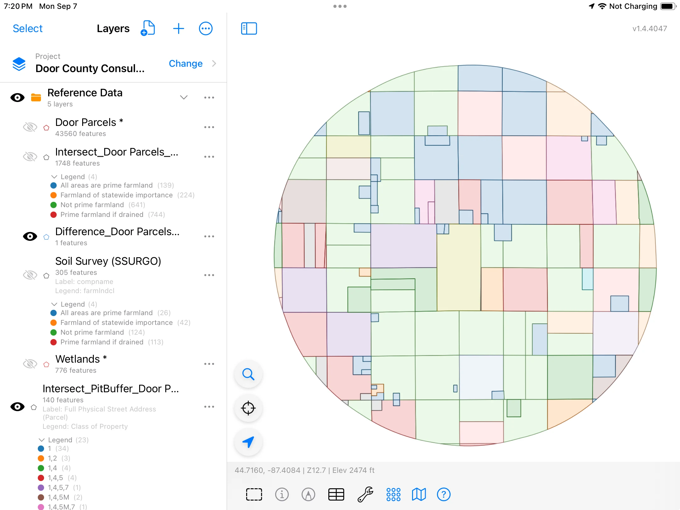
The tools run without a signal, so you can download soils or flood zones in the office and cut them in the field. Step by step: buffer, intersect, difference and dissolve.
Collecting in the Field
Collect a point at your GPS position, or place it by hand. GoGIS shows the reported accuracy before you save, and keeps it with the record. Lines and polygons can be digitized too.
Each layer gets its own form. Fields can be pick lists and multi-select lists, radio buttons, yes/no switches, dates, ratings, text, photos, sketches, signatures, or a barcode or QR code scanned with the camera. Calculated fields do the arithmetic: a total cost from acres and a rate, or the days since the last visit.
Related Forms keep a history: one culvert, many inspections; one meter, many readings. Each visit is its own dated record, linked to the feature, and rules can show follow-up questions only when an answer calls for them.
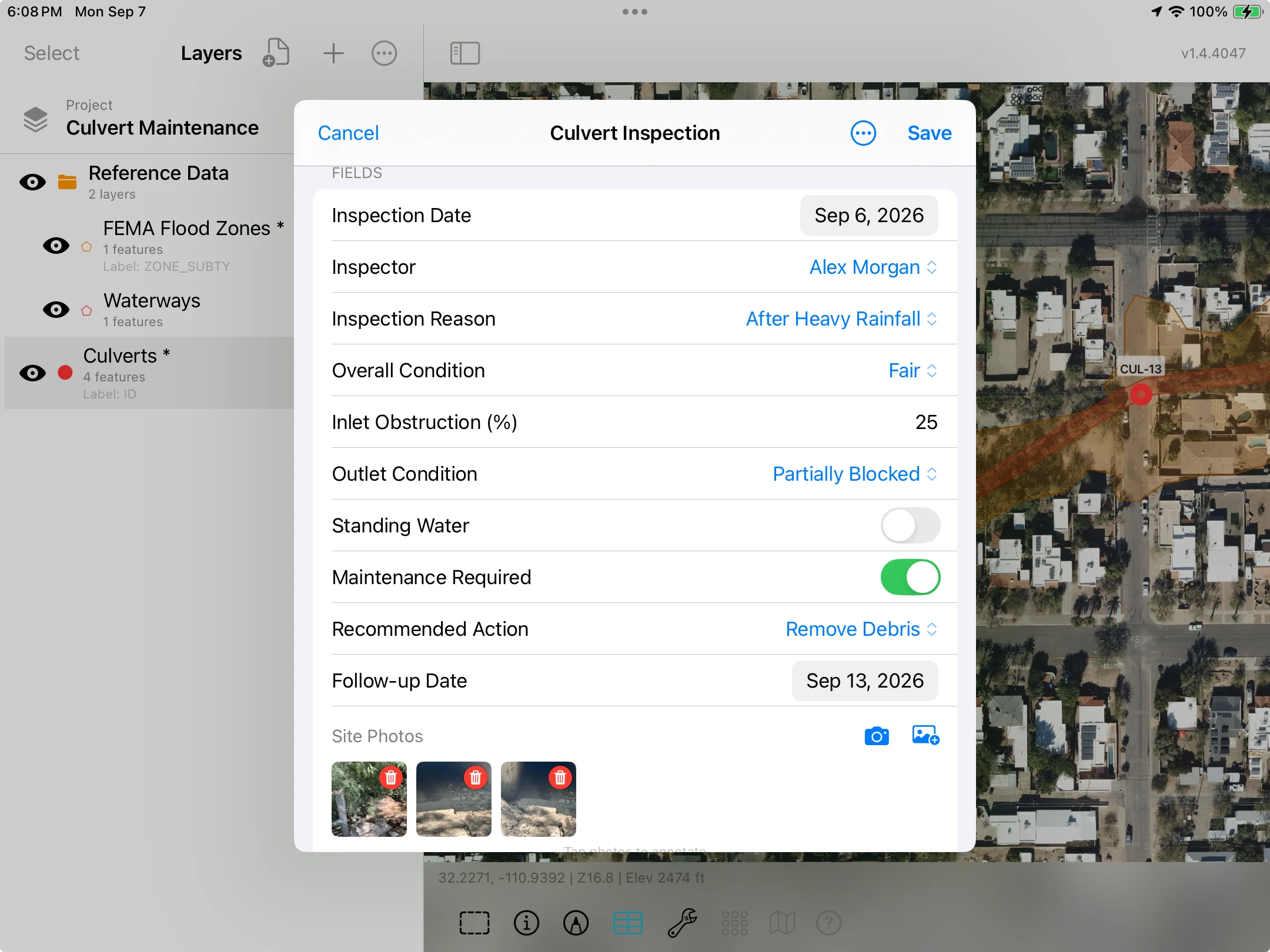
Guides: GPS field data collection, custom forms and Related Forms. For better accuracy than the built-in GPS, GoGIS supports Bad Elf receivers on iPhone and iPad.
Sampling, from Grid to Report
For soil and other grid sampling, GoGIS lays out numbered points inside a field boundary at the cell size you set, in acres or hectares, with rotation and offset. It prints QR or Code 128 bag labels on A4 or US Letter, routes you to the next point, and matches the lab's CSV back to each sample by Bag ID. Then it maps a result, such as pH, as an interpolated surface, and exports a PDF report.
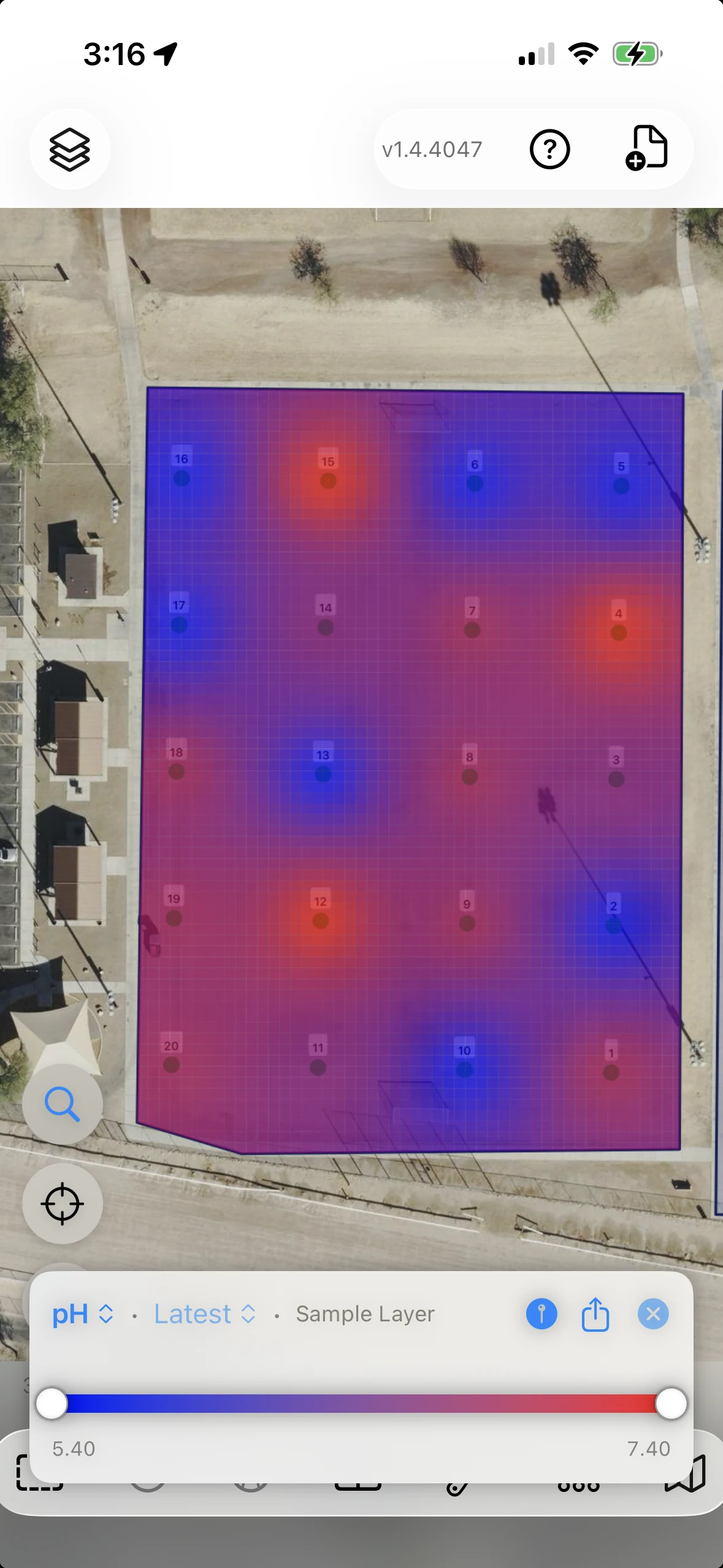
The whole workflow: soil sampling app for iPhone and iPad.
Reference Data, Ready to Download
Much of the public data a GIS job needs is a menu away. In the Layers panel, tap Import, then Reference Data. There's no key and no account, nothing to unzip, and each dataset arrives as a layer you can tap, edit, take offline and export.
- United States: SSURGO soils and FEMA flood zones, wetlands, rivers, the BLM's PLSS grid and mining claims, and tax parcels for 19 states and DC.
- Elsewhere: parcels for 23 European countries, Brazil, Colombia, Australia, New Zealand and Japan, France's PLU zoning, Canada's Crown land and protected areas, Europe's national parks and nature reserves, and soil maps from Canada to Córdoba. Reference Data by country
- Anywhere: OpenStreetMap roads, rivers, buildings and land use.
What Works Offline
Imported layers and collected records live on the device. With no signal you can still view and query your layers, use the GPS, collect and edit, fill forms, and run the geometry tools.
Basemaps need planning. GoGIS downloads basemaps for offline use from USGS sources in the United States and GSI sources in Japan, and from custom tile servers. Elsewhere, bring your own imagery as GeoTIFF or MBTiles, which is stored on the device once imported. Don't count on map imagery you happened to view earlier being there offline. See offline maps for fieldwork.
One Project, Several Devices
Field Sync exchanges project changes between nearby devices over a local connection, with no cloud account: iPhone to iPad, phone to tablet, or Apple to Android. New features, edits, deletions, photos and Related Form records go across. If two people edit the same record before syncing, the newer version wins, so a crew should agree who edits what. More in the FAQ.
GoGIS on Android uses the same formats, forms and tools. And on a Mac with Apple silicon, the iPad app runs at your desk: see GIS software for Mac.
What It Isn't
- Not a raster processing package. Imagery is for display. Use an 8-bit RGB GeoTIFF; raw multispectral or elevation rasters are for processing, not for an imagery layer.
- Not survey grade on its own. A phone's GPS is typically good to 3 to 5 meters in open sky. Work that needs better calls for an external receiver and a suitable procedure.
- Not a worldwide basemap downloader. Built-in basemap downloads cover the United States and Japan, as above.
Questions
Is there real GIS software for the iPad?
Yes. GoGIS opens shapefiles, GeoPackage, KML, GeoJSON and CSV with all their attributes, edits them in a map and an attribute table, runs buffer, intersect, difference and dissolve on the device, and exports Shapefile, GeoPackage, GeoJSON, KML or CSV. It runs on iPad and iPhone, and on Android.
What GIS files can I open on an iPhone?
In GoGIS: zipped shapefiles, GeoPackage, KML and KMZ, GeoJSON, and CSV with coordinate columns, plus GeoTIFF and MBTiles imagery. Shapefiles with a .prj file are placed in their own coordinate system.
Does a GIS app work without internet?
GoGIS does. Imported layers, GPS, collecting, forms and the geometry tools all work with no signal. Built-in basemap downloads cover USGS sources in the United States and GSI sources in Japan; elsewhere, bring your own imagery as GeoTIFF or MBTiles. Downloads and online services need a connection.
Can I edit an attribute table on an iPad?
Yes. The Attribute Grid shows every feature as a row. Sort it, search it, total a column, edit a cell, or select many rows and set one value for all of them. Undo is offered right after each edit.
Does an iPad have GPS?
Wi-Fi + Cellular iPads do. Wi-Fi-only iPads don't have built-in GPS, so their position isn't a satellite fix. GoGIS also supports Bad Elf receivers on iPhone and iPad.
Does GoGIS run on Android and Mac?
Yes. GoGIS runs on Android phones and tablets with the same formats, forms and tools, and Field Sync exchanges changes between nearby Apple and Android devices. On Macs with Apple silicon it runs as the iPad app.
Do I need an account?
No. Your layers and records are stored on your device, and you choose when to export or share them.
Try it on your own files
Open the shapefile or GeoPackage you already have, and see it on your iPhone or iPad in a minute.
Get GoGIS on the App Store Get GoGIS on Google Play